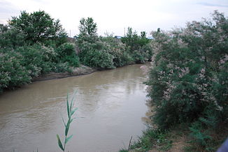
Kalaus
|
Kalaus Калаус |
||
|
The Kalaus in Swetlograd |
||
| Data | ||
| Water code | RU : 05010500212108200000711 | |
| location | Stavropol region ( Russia ) | |
| River system | Don | |
| Drain over | Manych → Don → Sea of Azov | |
| source | Kalau heights in the foothills of the Caucasus 44 ° 31 '42 " N , 42 ° 38' 49" E |
|
| Source height | approx. 490 m | |
| muzzle |
Manytsch coordinates: 45 ° 42 ′ 36 ″ N , 44 ° 6 ′ 0 ″ E 45 ° 42 ′ 36 ″ N , 44 ° 6 ′ 0 ″ E |
|
| Mouth height | 27 m | |
| Height difference | approx. 463 m | |
| Bottom slope | approx. 1.1 ‰ | |
| length | 436 km | |
| Catchment area | 9700 km² | |
| Discharge at the Vosdvishenskoye gauge Location: 60 km above the mouth |
MQ |
3.23 m³ / s |
| Left tributaries | Bolshoi Jankul , Gratschowka | |
| Right tributaries | Aigurka | |
| Medium-sized cities | Svetlograd , Ipatowo | |
The Kalaus ( Russian Кала́ус ) is a 436 km long tributary of the Manych in the foothills of the Caucasus . It flows through the Russian Stavropol region along its entire length . Formerly the right tributary of the Eastern Manych, thanks to hydraulic engineering measures it has actually been the source of the Western Manych since the 1970s.
The river has its source in the Kalaus heights (Prikalausskaja woswyschennost), the eastern part of the Stavropol ridge , on the southern flank of the 688 m high Bryk mountain. The source is a little southeast of the village of Verkhny Kalaus ("Upper Kalaus"), about 75 km as the crow flies southeast of the regional administrative center of Stavropol . A few kilometers below the source, water has been supplied to the Kalaus since 1967 via a branch of the Great Stavropol Irrigation Canal, which is taken from the Kuban near Nevinnomyssk . The Kalaus flows in a northerly direction past the town of Svetlograd , turns in an easterly direction at the town of Ipatowo and finally reaches the Kuma-Manych lowland about 40 km north of the district center of Arsgir , which is the border with the Republic of Kalmykia there and according to a common view marked the inner Eurasian border .
The river, which became a narrow trickle not least due to the intensive use for irrigation of agricultural land in its lower reaches, except during the snowmelt in February to April, originally flowed into the Eastern Manych, which, depending on the hydrological conditions in this section, usually flowed to the southeast. In the 1970s, the Manych was blocked off by a dam immediately south of the mouth of the Kalau, in connection with the creation of the Tschograi reservoir between 1969 and 1973, which is only fed by watercourses that flow further east, mainly the Tschograi and the Kuma -Manych irrigation canal . As a result of these measures, the Manych itself can only flow in a north-westerly direction from the confluence of the Kalau, to Lake Manych-Gudilo and on to the Don.
The most important tributaries of the Kalau are the Bolshoi Jankul and Gratschowka from the left and the Aigurka from the right. Its catchment area covers 9700 km². It is mainly fed by the snowmelt and rainfall. The mean discharge 60 km above the mouth is 3.23 m³ / s. The Kalaus usually freezes over from the first half of December to mid-March.
The Kalaus is the village Sergijewskoje from the regional road 07K-001 (formerly part of the R262) Stavropol - Aleksandrovskoe - Mineralnye Vody crossed. From Svetlograd to above Divnoye , the federal highway R216 Stavropol - Elista - Astrakhan and the railway line Mikhailovsk ( Palagiada station ) - Elista follow mostly some distance on the left side of the river. The railway line to Budyonnovsk - Georgievsk, which branches off from the latter, crosses it at Swetlograd .
Web links
Individual evidence
- ↑ Soviet General Staff Map 1: 100,000. Sheet L-38-122 (edition 1985)
- ↑ Soviet General Staff Map 1: 200,000. Sheet L-38-XXI (1994 edition)
- ↑ a b c d e f Article Kalaus in the Great Soviet Encyclopedia (BSE) , 3rd edition 1969–1978 (Russian)
- ↑ a b c d Kalaus in the State Water Directory of the Russian Federation (Russian)
