Kapellenberg (Ergoldsbach)
| Kapellenberg | ||
|---|---|---|
|
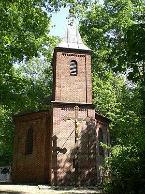
Lourdes Chapel on the Ergoldsbach Kapellenberg |
||
| height | 462 m above sea level NN | |
| location | Ergoldsbach , Bavaria | |
| Mountains | Lower Bavarian hill country | |
| Coordinates | 48 ° 41 ′ 27 " N , 12 ° 12 ′ 31" E | |
|
|
||
| Type | hill-like elevation | |
| rock | Sand, marl | |
| Age of the rock | 2–5 million years | |
The Kapellenberg (also called Schloßberg by the Bavarian State Surveying Office ) (464 m) is an elevation in the east of the Ergoldsbach market . It was formed 2 to 5 million years ago as part of the tertiary hill country through the deposition of sand and marl during the Miocene and formation during the Pliocene .
The Kapellenberg is mainly planted with deciduous forest , with the western part in particular being characterized by old maple , chestnut and beech trees. This part of the mountain is like a park applied, while the eastern part as coniferous forest forestry is operated. In the west and south the Kapellenberg is bounded by the center of Ergoldsbach, in the northeast it is bordered by a new building area , while the elevation slowly tapers to the southeast. The Kapellenberg plays a special role due to its diverse historical and current uses.
Park
The Kapellenberg serves as a park for the residents of the Ergoldsbach market. Three entrances and a multitude of paths open up the mountain. Park benches, vantage points and a number of monuments (including the Ergoldsbach Heimatlied by Josef Kropf and the market's deceased merit) can be found. In the north there is a festival meadow on which an oriental winter market takes place every year. Integrated into the park is a hill fort , a chapel , a Way of the Cross and a forest kindergarten .
The entire Kapellenberg was still bare in the 19th century. Cannons were set up on the ridge to announce special events or arriving celebrities with the thunder of guns. The recreational area described above was only created by planting the Ergoldsbach Citizens' Association in 1890. These were continued and intensified after the establishment of the Beautification Association in 1908. Today the park on the Kapellenberg forms a landscape protection area . A memorial stone was erected for the board members of both associations, Franz Xaver Steinherr and Georg Liedl, who were largely responsible for the creation of the park.
Wall fortress
At the western end of the ridge there is an early medieval hill fort , the so-called old hill . There are remains of ramparts and ditches from the double walling, which enclose a courtyard of almost 5000 m 2 on three sides. Towards the center of the village, the steep slope of the elevation did not require a fence. Possibly this side was secured with palisade work. The enclosed area is left unplanted as a meadow. In 1891, during a survey of the facility, the royal major general Carl Popp found that the outer trench was 13 m deep and 2.5 m wide. In addition, “(d) the distance between the crowns of the two walls, which are usually up to 2 m wide, was up to 22 m and the depth of the slightly broad-bottomed ditch or communication space between them was approx. 4 m. The old entrenchment at Ergoldsbach consists only of earth walls and ditches, the warping of which clings to the contour of the terrain and whose profiles, even if they have already been somewhat blurred, are still larger than would have been necessary for a simple field fortification. The high elevation of the ramparts, the depth of the trenches, the double rampart and the absence of building traces inside the plant indicate that we have a fortified castle in front of us, which claims only provisional value. "
Lourdes Chapel
In 1825 a newly built chapel already existed on the Kapellenberg. This was dismantled in 1895 and moved to Kläham . In the meantime this has been broken off - only a bell from the time from Ergoldsbach is there. In the same year, the pastor of Ergoldsbach at the time, Igl, had the new mountain chapel built on the northern outer wall of the fortress. It was completed in 1896 and is dedicated to Our Lady of Lourdes . Therefore, today it is usually referred to as the Lourdes Chapel for short . Church services are held here regularly and a rosary is prayed weekly .
Way of the Cross
In 1889 an additional way of the cross with fourteen stations was built as a staircase from the town center to the Lourdes Chapel. Stone columns with colored representations made of cast zinc were set up for this purpose. A fifteenth station was later added by the Ergoldsbacher Frauenbund .
Web links
Individual evidence
- ^ BayernAtlas of the Bavarian State Ministry of Finance and Home
- ↑ Landshuter Zeitung from June 20, 2019: Lively and religious landmark - The chapel is a historical local recreation and landscape protection area.
- ^ Castles and palaces in the Landshut district. ( Memento from April 22, 2009 in the Internet Archive ) In: burgeninventar.de.
- ^ Helmut Siegl: Ergoldsbach in Goldbachtal. Dr. Hanskarl Hornung Verlag, Munich 1984, pp. 12-13.
- ^ Helmut Siegl: Ergoldsbach in Goldbachtal. Dr. Hanskarl Hornung Verlag, Munich 1984, pp. 35, 52.
- ^ Helmut Siegl: Ergoldsbach in Goldbachtal. Dr. Hanskarl Hornung Verlag, Munich, 1984, p. 52.


