Karaman (city)
| Karaman | ||||
|
||||
 Karaman city center |
||||
| Basic data | ||||
|---|---|---|---|---|
| Province (il) : | Karaman | |||
| Coordinates : | 37 ° 11 ' N , 33 ° 13' E | |||
| Height : | 1039 m | |||
| Residents : | 165,858 (2019) | |||
| Telephone code : | (+90) 338 | |||
| Postal code : | 70 100 | |||
| License plate : | 70 | |||
| Structure and administration (as of 2019) | ||||
| Structure : | 56 Mahalle | |||
| Mayor : | Savaş Kalaycı ( MHP ) | |||
| Website: | ||||
| Karaman County | ||||
| Residents : | 197,276 (2019) | |||
| Surface: | 4,036 km² | |||
| Population density : | 49 inhabitants per km² | |||
Karaman , formerly Larende , ancient Greek Λάρανδα Laranda , Hittite perhaps Landa , is a Turkish city in Asia Minor and has 161,946 inhabitants (end of 2019). It is the provincial capital of the Karaman province of the same name , but was previously tied to Konya. The city is on the D715 between Konya and Silifke . The district of the same name is the largest in the province and, in addition to the district town ( Merkez ), consists of two other cities ( Belediye ): Sudurağı (2,260) and Akçaşehir (2,261 inhabitants) and 93 villages ( Köy ), four of which have over 1,000 inhabitants. The average population of the villages is 293 people.
history
During the Eastern Roman rule, the city was considered an important garrison town against the Islamic expansion trains. In 1165 the Seljuks conquered the city, which was wrested from them again by the Third Crusade and the accompanying short phase of the Kingdom of Lesser Armenia . In 1211 it was taken again. The city was given to the Karamanids by Kılıç Arslan IV as a thank you for their expansion moves. The city took the name Karaman in honor of this dynasty and was used as the capital of the principality from 1256 until the 14th century. In 1397 the Ottoman Sultan Bayezid I took the city, but was so weakened by Timur's forces that the Karamanids succeeded in recapturing it. In 1466 Larende was conquered by the Ottomans and after a few years the Karamaniden Beylik was finally smashed. After the Ottoman conquest, a phase of economic decline followed, which, however, ended with the conquest of Cyprus by the Ottomans, as Karaman was conveniently positioned near the Silk Road and near the port in Silifke .
In 1935 the city was connected to the power grid with the construction of a power station. On June 15, 1989, the city, which previously belonged to Konya Province, became the capital of the country's new province of the same name.
Population development
The following table shows the comparative population level at the end of the year for the province, the central district and the city of Karaman and the respective share at the higher administrative level. The figures are based on the address-based population register (ADNKS) introduced in 2007.
| year | province | district | city | ||
|---|---|---|---|---|---|
| real | percent | real | percent | real | |
| 2018 | 251.913 | 77.02 | 194.018 | 83.47 | 161,946 |
| 2017 | 246,672 | 77.17 | 190.366 | 83.30 | 158,566 |
| 2016 | 245.610 | 76.63 | 188.221 | 82.91 | 156.056 |
| 2015 | 242.196 | 76.18 | 184,493 | 82.53 | 152.256 |
| 2014 | 240,362 | 75.46 | 181.383 | 81.79 | 148,362 |
| 2013 | 237.939 | 74.68 | 177,685 | 81.14 | 144.178 |
| 2012 | 235.424 | 74.50 | 175.397 | 80.75 | 141,630 |
| 2011 | 234.005 | 73.87 | 172.854 | 79.91 | 138,135 |
| 2010 | 232,633 | 73.18 | 170.240 | 79.41 | 135.185 |
| 2009 | 231,872 | 72.47 | 168.048 | 78.59 | 132.064 |
| 2008 | 230.145 | 71.35 | 164.207 | 77.46 | 127.192 |
| 2007 | 226.049 | 70.86 | 160.179 | 76.67 | 122,809 |
Attractions
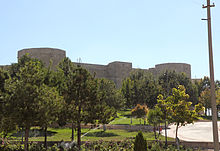
In the Yunus-Emre-Camii , the oldest building from the Karamanid period (1349), the grave of Yunus Emre (around 1280 to 1321) is said to be . To the west of the city is the Seljuk citadel of Karaman . Behind the Hatuniye Medresi in the city center is the Karaman Archaeological and Ethnographic Museum .
There are several caves within the borough that can be visited, including İncesu and Manazan caves. There is also a museum of archeology (from the Neolithic to modern times).
Climate table
| Karaman (1018 m) | ||||||||||||||||||||||||||||||||||||||||||||||||
|---|---|---|---|---|---|---|---|---|---|---|---|---|---|---|---|---|---|---|---|---|---|---|---|---|---|---|---|---|---|---|---|---|---|---|---|---|---|---|---|---|---|---|---|---|---|---|---|---|
| Climate diagram | ||||||||||||||||||||||||||||||||||||||||||||||||
| ||||||||||||||||||||||||||||||||||||||||||||||||
|
Average monthly temperatures and rainfall for Karaman (1018 m)
|
||||||||||||||||||||||||||||||||||||||||||||||||||||||||||||||||||||||||||||||||||||||||||||||||||||||||||||||||||||||||||||||||||||||||||||||||||||||
Others
The license plates of the city and province begin with the number 70.
Sons and daughters (selection)
- Ömer Dinçer (* 1956), Turkish politician
- Lütfi Elvan (* 1962), Turkish politician and Minister for Transport, Communication and Maritime Affairs.
- Fadime Örgü (* 1968), politician from the Netherlands
- Giray Kaçar (* 1985), football player
literature
- AH de Groot, HA Reed, JM Rogers: Lāranda. In: The Encyclopaedia of Islam. New Edition . Vol. 5, Brill, Leiden, pp. 676-682.
See also
Web links
- Official Tourism Site (Turkish)
Individual evidence
- ↑ a b Nufusune.com , accessed April 13, 2020
- ^ Wolfgang Dorn: Turkey, Central Anatolia: between Phrygia, Ankara and Cappadocia. DuMont Reiseverlag, 2006, p. 256.
- ↑ Central Dissemination System / Merkezi Dağıtım Sistemi (MEDAS) of the TÜIK , accessed on May 5, 2019
- ↑ Turkey City Guide: Karaman .


