Kennedy Highway
| Kennedy Highway Kennedy Developmental Road |
|||||||||||||||||||||||||||||||||||||||||||||||||||||||||||||||||||||||||||||||||||||||||||||||||||||||||||||||||||||||||||||||||||||||||||||||||||||||||||||||||||||||||||||||||||||||||||||||||||||||||||||
|---|---|---|---|---|---|---|---|---|---|---|---|---|---|---|---|---|---|---|---|---|---|---|---|---|---|---|---|---|---|---|---|---|---|---|---|---|---|---|---|---|---|---|---|---|---|---|---|---|---|---|---|---|---|---|---|---|---|---|---|---|---|---|---|---|---|---|---|---|---|---|---|---|---|---|---|---|---|---|---|---|---|---|---|---|---|---|---|---|---|---|---|---|---|---|---|---|---|---|---|---|---|---|---|---|---|---|---|---|---|---|---|---|---|---|---|---|---|---|---|---|---|---|---|---|---|---|---|---|---|---|---|---|---|---|---|---|---|---|---|---|---|---|---|---|---|---|---|---|---|---|---|---|---|---|---|---|---|---|---|---|---|---|---|---|---|---|---|---|---|---|---|---|---|---|---|---|---|---|---|---|---|---|---|---|---|---|---|---|---|---|---|---|---|---|---|---|---|---|---|---|---|---|---|---|---|
 
|
|||||||||||||||||||||||||||||||||||||||||||||||||||||||||||||||||||||||||||||||||||||||||||||||||||||||||||||||||||||||||||||||||||||||||||||||||||||||||||||||||||||||||||||||||||||||||||||||||||||||||||||
| Basic data | |||||||||||||||||||||||||||||||||||||||||||||||||||||||||||||||||||||||||||||||||||||||||||||||||||||||||||||||||||||||||||||||||||||||||||||||||||||||||||||||||||||||||||||||||||||||||||||||||||||||||||||
| Operator: | Dept. of Transport and Main Roads | ||||||||||||||||||||||||||||||||||||||||||||||||||||||||||||||||||||||||||||||||||||||||||||||||||||||||||||||||||||||||||||||||||||||||||||||||||||||||||||||||||||||||||||||||||||||||||||||||||||||||||||
| Start of the street: |
Smithfield ( QLD ) ( 16 ° 50 ′ S , 145 ° 42 ′ E ) |
||||||||||||||||||||||||||||||||||||||||||||||||||||||||||||||||||||||||||||||||||||||||||||||||||||||||||||||||||||||||||||||||||||||||||||||||||||||||||||||||||||||||||||||||||||||||||||||||||||||||||||
| End of street: |
D83 Diamantina Developmental Road 83 Donohue Highway Boulia ( QLD ) ( 22 ° 55 ′ S , 139 ° 56 ′ E ) |
||||||||||||||||||||||||||||||||||||||||||||||||||||||||||||||||||||||||||||||||||||||||||||||||||||||||||||||||||||||||||||||||||||||||||||||||||||||||||||||||||||||||||||||||||||||||||||||||||||||||||||
| Overall length: | 1163 km | ||||||||||||||||||||||||||||||||||||||||||||||||||||||||||||||||||||||||||||||||||||||||||||||||||||||||||||||||||||||||||||||||||||||||||||||||||||||||||||||||||||||||||||||||||||||||||||||||||||||||||||
|
States : |
|||||||||||||||||||||||||||||||||||||||||||||||||||||||||||||||||||||||||||||||||||||||||||||||||||||||||||||||||||||||||||||||||||||||||||||||||||||||||||||||||||||||||||||||||||||||||||||||||||||||||||||
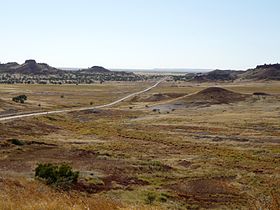
| Kennedy Development Road from Cornpore Lookout between Middleton and Boulia | |||||||||||||||||||||||||||||||||||||||||||||||||||||||||||||||||||||||||||||||||||||||||||||||||||||||||||||||||||||||||||||||||||||||||||||||||||||||||||||||||||||||||||||||||||||||||||||||||||||||||||||
|
Course of the road
|
|||||||||||||||||||||||||||||||||||||||||||||||||||||||||||||||||||||||||||||||||||||||||||||||||||||||||||||||||||||||||||||||||||||||||||||||||||||||||||||||||||||||||||||||||||||||||||||||||||||||||||||
The Kennedy Highway is a trunk road in Queensland , Australia . It runs over a length of 1163 km from Cairns in northeast Queensland in a south-westerly direction to Boulia in the mid-west of the country. The first section to the junction of the Gulf Developmental Road is part of the National Highway 1 , which circles the entire Australian continent.
course
Smithfield - Forty Mile Scrub National Park
The Kennedy Highway branches off from the Captain Cook Highway in Smithfield , a suburb about twelve kilometers north of central Cairns, and is marked there as Highway 1 . It meanders first into the mountains west of Cairns to Kuranda and on to Mareeba . From Mareeba it continues south through the Atherton Tablelands and passes the towns of Atherton , Ravenshoe and Mount Garnet.
After the Kennedy Highway has reached the Forty Mile Scrub National Park about 45 kilometers south of Mount Garnet, Highway 1 branches off to the west as the Gulf Developmental Road and leads to Normanton .
Forty Mile Scrub National Park - Hughenden
The Kennedy Highway continues in a southwesterly direction, but after this junction is referred to as Kennedy Developmental Road (State Route 62).
At Lynd Junction, the Gregory Highway from Charters Towers crosses the Kennedy Developmental Road, which continues to Hughenden in the south. The Flinders Highway , which runs from Townsville to Cloncurry , crosses in Hughenden .
Hughenden - Boulia
From Hughenden from the Kennedy Developmental Road continues in a south-westerly direction for 214 km to Winton , where it crosses the Landsborough Highway .
The last section of the Kennedy Developmental Road leads from Winton to the west over 362 km to Boulia, where the road continues into the Northern Territory as the Donohue Highway . This last section of the Kennedy Developmental Road - also known as the Min Min Way - is also the first section of the Outback Highway .
source
Steve Parish: Australian Touring Atlas . Steve Parish Publishing. Archerfield QLD 2007. ISBN 978-1-74193-232-4 . Pp. 13, 14, 16, 17
