Chopjor
|
Chopjor Хопёр, choper |
||
|
Chopjor near Slashchevskaya in Volgograd Oblast |
||
| Data | ||
| Water code | RU : 05010200112107000005186 | |
| location | Oblast Penza , Saratov , Voronezh Oblast , Volgograd Oblast ( Russia ) | |
| River system | Don | |
| Drain over | Don → Black Sea | |
| source |
Volga plate southwest of Penza 53 ° 3 ′ 53 ″ N , 44 ° 20 ′ 58 ″ E |
|
| Source height | approx. 215 m | |
| muzzle |
Don coordinates: 49 ° 36 ′ 23 " N , 42 ° 18 ′ 29" E 49 ° 36 ′ 23 " N , 42 ° 18 ′ 29" E |
|
| Mouth height | 49 m | |
| Height difference | approx. 166 m | |
| Bottom slope | approx. 0.17 ‰ | |
| length | 979 km | |
| Catchment area | 61,100 km² | |
| Outflow location: 45 km above the mouth |
MQ MHQ |
150 m³ / s 2720 m³ / s |
| Left tributaries | Busuluk , Serdoba , Kumylga | |
| Right tributaries | Worona , Sawala , Karai | |
| Medium-sized cities | Balashov , Borisoglebsk , Urjupinsk | |
| Small towns | Poworino , Arkadak , Novochopjorsk | |
| Navigable | 323 km | |
|
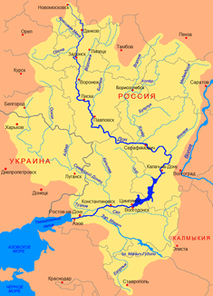
Course of the Chopjor (Хопёр) in the catchment area of the Don |
||
The 979 km long Chopjor ( Russian Хопёр , German also Choper ) is a left tributary of the Don in the European part of Russia .
The river rises on the western edge of the Volga plateau southwest of the city of Penza . From there it flows in a southerly direction to its confluence with the Don. Its catchment area is 61,100 km² and 323 km are navigable.
Web links
Commons : Chopjor - collection of images, videos and audio files


