Worona
|
Worona Воро́на |
||
|
|
||
| Data | ||
| Water code | RU : 05010200212107000006182 | |
| location | Oblaste Penza , Tambov Voronezh ( Russia ) | |
| River system | Don | |
| Drain over | Chopjor → Don → Black Sea | |
| source |
Volga plate west of Kamenka 53 ° 16 ′ 59 ″ N , 43 ° 34 ′ 45 ″ E |
|
| Source height | approx. 240 m | |
| muzzle |
Chopjor near Borissoglebsk Coordinates: 51 ° 21 ′ 3 " N , 42 ° 2 ′ 20" E 51 ° 21 ′ 3 " N , 42 ° 2 ′ 20" E |
|
| Mouth height | 85 m | |
| Height difference | approx. 155 m | |
| Bottom slope | approx. 0.34 ‰ | |
| length | 454 km | |
| Catchment area | 13,200 km² | |
| Drainage at the Borisoglebsk gauge |
MQ MHQ |
41.5 m³ / s 650 m³ / s |
| Left tributaries | Chembar , Karai | |
| Right tributaries | Ira | |
| Medium-sized cities | Kirsanov , Uvarowo , Borisoglebsk | |
| Small towns | Inschawino , Mutschkapski | |
|
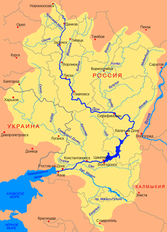
Location of the Worona in the Don basin |
||
The Worona ( Russian Воро́на ) is a 454 km long right tributary of the Chopjor in the European part of Russia .
course
The Worona rises at a height of about 240 m in the Kerensk-Chembar ridge , which extends in the western part of the Volga plateau and is named after the old names of the places Kerensk and Chembar in this area , today Vadinsk and Belinsky . Over its entire length it flows through the western part of the Volga plateau in southwest to southern directions in the area of its transition into the Oka-Don plain .
The forest steppe landscape through which it was initially flowed gradually changes into steppe on the lower reaches of the river , but has been changed to a considerable extent everywhere by agricultural use. The river valley itself, for which a steep and high right (western) and flat, terraced left (eastern) bank is characteristic for long stretches , is covered by deciduous forests in a width of a few kilometers in many places . On the lower reaches of the 15,000 hectare Tellermanowski Forest with up to 300 years old, artificially created pedunculate oak stands .
At the city of Borisoglebsk the Vorona finally flows into the Don tributary Chopjor. In the lower reaches their width reaches about 40 meters, the depth two meters. The flow velocity is 0.1 m / s.
The most important tributaries are the Chembar and Karai from the left and the Ira from the right.
Hydrology
The catchment area of the river covers 13,200 km².
The mean annual runoff near the mouth of Borissoglebsk is 41.5 m³ / s and increases on average to 650 m³ / s during the spring flood. The river freezes over from early December to early April.
The mineral content of the water varies between 150 and 350 mg / l in spring and 700–800 mg / l in winter. The average suspended matter content is between 100 and 250 g / m³.
Use and infrastructure
The Worona is not navigable. It serves the water supply of the places on the river as well as the irrigation of agricultural areas. The river is used for fishing and recreation.
Because of its mostly quiet course through undisturbed, dense deciduous forests, the Worona is a popular destination for technically relatively simple but extensive canoe tours , for example from Kirsanow to Borisoglebsk over 278 kilometers.
Areas totaling 11,206 hectares on the middle course of the river, between Kirsanow and Inschawino , were placed under nature protection in 1994 as a Worona nature reserve (Voroninski sapowednik ) .
The Ryashsk - Penza - Syzran railway runs in close proximity to the source of the Worona . Not far from the small town of Belinsky, which is a bit off the river, the R209 trunk road , which connects Penza with Kirsanov, crosses it and follows its course some distance away. At Kirsanow the railway line ( Moscow -) Michurinsk - Saratov and the following trunk road R209 from Tambov to Saratow cross the river, between Uvarowo and Mutschkapski the railway line Tambov - Balashov - Kamyshin . The railway line (Moscow -) Grjasi - Volgograd and the trunk road A144 , which as part of the European route 38 leads from Kursk via Voronezh to Saratov, cross it near the mouth near Borisoglebsk .
Individual evidence
- ↑ a b c d Article Worona in the Great Soviet Encyclopedia (BSE) , 3rd edition 1969–1978 (Russian)
- ↑ a b Worona in the State Water Directory of the Russian Federation (Russian)
- ↑ a b Slovar ʹ sovremennych geografičeskich nazvanij . U-Faktorija, Yekaterinburg 2006 (Russian, entry Worona ).
- ↑ Yuri Voronov: 100 izbrannych maršrutov dlja putešestvij na bajdarke . Mir, Moscow 1993 ( 100 selected routes for canoe tours ; Russian; chapter on Worona ).
- ↑ Voroninsky sapovednik in the information and information system Specially Protected Natural Areas of Russia of the Center for Nature Conservation (Russian)
