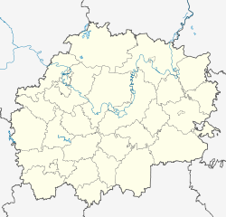
Ryashsk
| city
Ryashsk
Ряжск
|
||||||||||||||||||||||||||||||||||||||||
|
||||||||||||||||||||||||||||||||||||||||
|
||||||||||||||||||||||||||||||||||||||||
| List of cities in Russia | ||||||||||||||||||||||||||||||||||||||||
Rjaschsk ( Russian Ряжск ) is a city in the Ryazan Oblast ( Russia ) with 21,674 inhabitants (as of October 14, 2010).
geography
The city is located on the northwestern edge of the Oka-Don plain about 120 km southwest of the Oblast capital Ryazan on the Chupta , a right tributary of the Ranowa in the river system of the Volga .
Ryashsk is the administrative center of the raion of the same name .
history
The place was first mentioned in 1502 under the name Ryassk . It was a fortified settlement that controlled the land connection ( Wolok ) between the rivers Khupta (basin of the Oka ) and Stanovaya Ryassa (basin of the Don ). In the 16th and 17th centuries, the names Rjaskoi and Rjaskow were also found. During this time the place belonged to the fortifications along the then southeast border of the Russian Empire.
In 1778 the city charter was granted as the administrative center of a district ( Ujesds ) in Ryazan Governorate .
Around 1870 the city became an important railway junction. The settlement at the train station, about three kilometers east of the old city center, was spun off in 1927 as an urban-type settlement with the name Novorjaschski, later also Novo-Rjaschsk ("New Rjaschsk"), but was incorporated again in 1962.
Population development
| year | Residents | Remarks |
|---|---|---|
| 1897 | 14,835 | |
| 1926 | 16,200 | |
| 1939 | 10,566 | of which Ryashsk 5,505, Novo-Ryashsk 5,061 |
| 1959 | 14,768 | of which Ryashsk 7,414, Novo-Ryashsk 7,354 |
| 1970 | 25,425 | |
| 1979 | 25,250 | |
| 1989 | 27,217 | |
| 2002 | 22,850 | |
| 2010 | 21,647 |
Note: census data (1926 rounded)
Culture and sights
The city has a local museum.
In the village of Bolshaya Aleschnja in the Ryashsk district, nine kilometers away, is the former country residence of the Kikin- Yermolow family with the Church of the Mother of God ( Рождественская церковь / Roshdestwenskaja zerkow) from 1805.
In Saborowo (also Spasskoje ), 35 kilometers away , is the former country residence of General Mikhail Skobelew (1843–1882), hero of the Russo-Ottoman War 1877–1878 and the Russian conquest of Turkestan , which was held in the Church of the Savior there ( Спасская церковь / Spass ) from 1764 is buried.
Economy and Infrastructure
In Ryashsk there are companies in the food industry and a security printing plant.
The city is a major rail hub . Here the lines intersect Moscow ( Paveletskaya Station ) - or Smolensk - Tula -Rjaschsk- Penza (Station Ryazhsk I ) and Moscow ( Kazan station ) -Rjasan- Voronezh or - Tambov - Saratov (Station Ryazhsk II , kilometer 313).
The regional road R126 Ryazan - Dankow - Jefremow runs through Ryashsk .
Individual evidence
- ↑ a b Itogi Vserossijskoj perepisi naselenija 2010 goda. Tom 1. Čislennostʹ i razmeščenie naselenija (Results of the All-Russian Census 2010. Volume 1. Number and distribution of the population). Tables 5 , pp. 12-209; 11 , pp. 312–979 (download from the website of the Federal Service for State Statistics of the Russian Federation)
Web links
- City administration website (Russian)
- Ryashsk on mojgorod.ru (Russian)


