Skopin
| city
Skopin
Скопин
|
||||||||||||||||||||||||||||||||||||||||
|
||||||||||||||||||||||||||||||||||||||||
|
||||||||||||||||||||||||||||||||||||||||
| List of cities in Russia | ||||||||||||||||||||||||||||||||||||||||
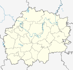
Skopin ( Russian Скопин ) is a Russian city with 30,376 inhabitants (as of October 14, 2010) in the central Russian Oblast of Ryazan . It is located 109 kilometers southwest of the regional capital Ryazan on the Wjorda River , in the plain through which the Oka flows. The closest city is Novomichurinsk , which is 27 km northeast of Skopin.
history
Skopin is one of the oldest cities in Ryazan Oblast. In the 12th century, under the name Licharewskoje Gorodishche (Russian: Лихаревское городище) a settlement was founded near what is now the urban area. In the 16th century, a sentry was established on the southern border of the Moscow area with the name Ostroschek (Russian: Острожек). At the end of the 16th century, the city was initially called Skopinskaja Sloboda , the name Skopin is then used for the first time from around 1595 to 1597. The tsar had a wooden citadel ( Kremlin ) built there in 1663 . In the 18th century the place lost its military importance.
Skopin was briefly occupied by the German Wehrmacht during the Battle of Moscow in the German-Soviet War (1941-45) .
In the 1960s, the urban-type Metallurgy settlement that was built in the 1940s was incorporated . In 2004 the urban-type settlement a good 10 km south, founded in 1927 as Pobedinski and renamed Saretschny in 1963, as well as the 6 km south-west, Oktjabrski settlement, which was also elevated to an urban-type settlement in 1934 (the coal mine is now closed), were incorporated into Skopin after they had previously been subordinate to the city administration.
Population development
| year | Residents | ||||
|---|---|---|---|---|---|
| Skopin | Oktyabrsky | Pobedinski, from 1963 Saretschny |
Metallurg | total | |
| 1897 | 13,247 | 13,247 | |||
| 1939 | 13,250 | 2,481 | 1,165 | 16,896 | |
| 1959 | 17,957 | 5,599 | 4,305 | 3,036 | 30,897 |
| 1970 | 24,429 | 5,563 | 4,837 | 34,829 | |
| 1979 | 26,608 | 5,227 | 4,302 | 36,137 | |
| 1989 | 28,912 | 5,599 | 3,798 | 38,309 | |
| 2002 | 25.092 | 4,936 | 3,147 | 33,175 | |
| 2010 | 30,376 | 30,376 | |||
Note: census data
economy
Since the second half of the 19th century, lignite was mined on the outskirts of Skopin , and mining was stopped in 1989. Today, the city's industries are engineering , light industry , building materials, and the food industry . Skopin is also known for its ceramic products and refractory clay minerals .
sons and daughters of the town
- Ioann Dobroljubow (1838–1905), local historian, priest
- Pawel Sytin (1870–1938), Russian and Soviet officer, major general in the tsarist army
- Anatoly Novikow (1896–1984), composer
- Vasily Orlow (1896–1974), Soviet theater and film actor, educator
- Pawel Makarow (1897–1970), Russian and Soviet military, during the civil war - saboteur and spy for the Red Army
- Ksenija Serbina (1903–1990), historian
- Alexander Afinogenow (1904–1941), playwright
- Sergei Birjusow (1904–1964), Marshal of the Soviet Union
- Ivan Lukinski (1906–1986), Soviet film director
- Vladimir Bunin (1908–1970), composer
- Anatoli Jegorow (1920–1997), philosopher
- Nina Tamarina (* 1926), entomologist
- Sergei Choruschi (* 1941), physicist, philosopher, translator of Joyce's works
Individual evidence
- ↑ a b Itogi Vserossijskoj perepisi naselenija 2010 goda. Tom 1. Čislennostʹ i razmeščenie naselenija (Results of the All-Russian Census 2010. Volume 1. Number and distribution of the population). Tables 5 , pp. 12-209; 11 , pp. 312–979 (download from the website of the Federal Service for State Statistics of the Russian Federation)
Web links
- City website (Russian)
- Skopin on mojgorod.ru (Russian)


