
Saposhok (Ryazan)
| Urban-type settlement
Saposhok
Сапожок
|
||||||||||||||||||||||||||||||||||
|
||||||||||||||||||||||||||||||||||
|
||||||||||||||||||||||||||||||||||
.png)
.png)
.svg)

Saposhok ( Russian Сапожо́к ) is an urban-type settlement and former city in the Ryazan Oblast in Russia with 3878 inhabitants (as of October 14, 2010).
geography
The place is about 100 km as the crow flies southeast of the administrative center of Ryazan on the river Moschka, a little above its confluence with the left Para tributary Poschwa.
Saposchok is the administrative center of the Rajons Saposchkowski and seat of the municipality Saposchkowskoje gorodskoje posselenije, are among the 14 other surrounding villages: the villages Obreski, Kupalskoje, Kurgan, Popova Loschtschina and Chernaya Rechka, the Sloboda Bolshaya Doroga, Fabritschnaja and Schazkaja and settlements Blagodatny, Gluschizy , Gribow Kust, Krasnyje Lipjagi, Maximowka and Possjolok Uchebnowo chosjaistwa SPTU No. 1 ("Settlement of the teaching industry of the vocational school No. 1").
history
The place was first mentioned in documents in 1605; This year is considered the founding year, although the original Ostrog in the course of the Russian Verhaulinien probably already in the 16th century under Ivan IV. was erected. In 1780 Saposhok received city rights as the administrative seat of a Ujesd of the governorship, from 1796 of the Ryazan governorate .
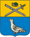
City coat of arms from 1779

Postage stamp from the Zemstvo -Post des Ujesds Saposchok (1909)
_(1779).png)
.jpg)
With the dissolution of the Ujesd in 1924 and the loss of its administrative function, Saposchok lost its town charter and from then on had the status of a village (selo) , but on July 12, 1929 it was again the administrative seat of a newly created Rajon named after him. Saposhok has had urban-type settlement status since 1940.
Population development
| year | Residents |
|---|---|
| 1859 | 4871 |
| 1897 | 8550 |
| 1939 | 3280 |
| 1959 | 4343 |
| 1970 | 4602 |
| 1979 | 5925 |
| 1989 | 5313 |
| 2002 | 4392 |
| 2010 | 3878 |
Note: from 1897 census data
traffic
On the eastern edge of the village, Saposhok is bypassed by the regional road 61K-009, which begins in Ryashsk, just under 50 km south-west, not far from the federal trunk road R22 Kaspi , leads through the neighboring district center of Ucholowo and continues via Schilowo (not far from the M5 ) and Kassimow to the border of the oblast Nizhny Novgorod runs. To the east, the 61K-015 branches off to the Rajon centers of Sarai and Schazk .
The nearest railway stations are in passenger the good 25 km away Kensino at Ucholowo, on the track ( Moscow -) Ryazhsk - Penza - Syzran , and a train yard in a few kilometers closer Ucholowo.
Web links
Individual evidence
- ↑ a b Itogi Vserossijskoj perepisi naselenija 2010 goda. Tom 1. Čislennostʹ i razmeščenie naselenija (Results of the All-Russian Census 2010. Volume 1. Number and distribution of the population). Tables 5 , pp. 12-209; 11 , pp. 312–979 (download from the website of the Federal Service for State Statistics of the Russian Federation)
| Cities |
Kassimov S / R | Korablino R | Mikhailov R | Novomichurinsk | Ryazan S / R | Ryashsk R | Rybnoye R | Sassowo S / R | Schazk R | Skopin S / R | Spas-Klepiki R | Spassk-Ryazansky R. |
|
| Urban-type settlements |
Alexandro-Nevsky R | Gus-Schelesny | Jelatma | Jermisch R | Kadom R | Lesnoi | Miloslavskoye R | Oktyabrsky | Pavelets | Pitelino R | Pobedinka | Pronsk R | Saposhok R | Sarai R | Schilowo R | Staroshilovo R | Syntul | Chuchkovo R | Tuma | Ucholowo R | Zentralny |
|
| Other Rajon centers |