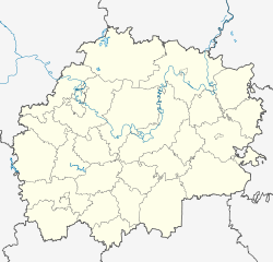
Kadom
| Urban-type settlement
Kadom
Кадом
|
||||||||||||||||||||||||||||||||||
|
||||||||||||||||||||||||||||||||||
|
||||||||||||||||||||||||||||||||||
Kadom ( Russian Ка́дом ) is an urban-type settlement and former city in the Ryazan Oblast in Russia with 5478 inhabitants (as of October 14, 2010).
geography
The village is located about 175 km as the crow flies east of the Ryazan Oblast Administrative Center on both sides of the right-hand Oka tributary, the Moksha , just under ten kilometers from the border with the Republic of Mordovia .
Kadom is the administrative center of Kadomski Rajon and the seat of the municipality of Kadomskoje gorodskoje posselenije, which also includes the villages of Bolshoye Lunino (7 km west-northwest), Krutez (9 km west), Maloje Lunino (6 km north-west), Preobrashenka (6 km north-north-west) (5 km west) and the settlement Ilyinovka (9 km west) belong.
history
The place was first mentioned in the Nikon Chronicle from the 16th century, in which 1209 is given as the year of foundation of the place. It was initially six kilometers upstream on the right bank, where today the village of Stary Kadom ("Old Kadom") is located. In the 15th century, due to frequent floods, Kadom was moved to the more favorable current location and a fortress was built there. From that time until the end of the 17th century, Kadom belonged to the Tatar Principality of Kassimow , a fief of the Grand Duchy of Moscow .
In 1779 Kadom received city rights as the administrative seat of a Ujesd of the governorship of Tambov (later Tambov governorate ). It lost its administrative function as early as 1787, but remained a town until 1926. However, the economic development stagnated, especially since the place was largely bypassed by the railway lines built in the 19th century.
On July 12, 1929, Kadom became the administrative seat of a newly created Rajons named after him. In 1958 it received urban-type settlement status.
Population development
| year | Residents |
|---|---|
| 1861 | 7365 |
| 1897 | 6314 |
| 1939 | 5748 |
| 1959 | 8744 |
| 1970 | 7598 |
| 1979 | 7484 |
| 1989 | 7250 |
| 2002 | 6181 |
| 2010 | 5478 |
Note: from 1897 census data
economy
Kadom has been known for its lace and embroidery products since the 18th century . These are known in Russian as Kadomski wenis ( Кадомский вениз ), from Venice for Venice , from where the technology was brought to various places in the region, including Kadom, before it was adapted there - influenced by Russian folk art.
traffic
The regional road 61K-030 leads to Kadom, which branches off about 40 km (54 km by road) southwest in Sassowo from the 61K-012 Schazk (on the M5 ) - Kassimow. Sassovo is also the nearest train station on the Moscow - Ryazan - Rusajewka - Syzran route .
A small airfield just south of Kadom has been out of service since the 1990s.
Personalities
- Vasily Shestakov (1891–1956), Soviet politician
- Nikolai Kharlamov (1892–1938), Soviet military, head of the Central Aero- and Hydrodynamic Institute (ZAGI)
- Sergei Batyshev (1915–2000), Soviet military, educator and scientist
- Nina Kinjapina (1920–2003), historian
- Dmitri Kaprin (* 1921), Soviet military
Web links
Individual evidence
- ↑ a b Itogi Vserossijskoj perepisi naselenija 2010 goda. Tom 1. Čislennostʹ i razmeščenie naselenija (Results of the All-Russian Census 2010. Volume 1. Number and distribution of the population). Tables 5 , pp. 12-209; 11 , pp. 312–979 (download from the website of the Federal Service for State Statistics of the Russian Federation)
- ↑ O. Kosaderowa: Kadomski wenis . In: Chudozhnik. Issue 2, 2008.


