Kija (Chulym)
|
Kija Кия |
||
|
Course of the Kija (Кия) in the catchment area of the Chulym |
||
| Data | ||
| Water code | RU : 13010400212115200018064 | |
| location | Kemerovo Oblast , Tomsk Oblast ( Russia ) | |
| River system | If | |
| Drain over | Tschulym → Ob → Arctic Ocean | |
| source |
Kuznetsk Alatau 54 ° 37 ′ 23 ″ N , 88 ° 25 ′ 54 ″ E |
|
| Source height | approx. 1250 m | |
| muzzle |
Tschulym coordinates: 56 ° 51 '11 " N , 86 ° 39' 54" E 56 ° 51 '11 " N , 86 ° 39' 54" E |
|
| Mouth height | 99 m | |
| Height difference | approx. 1151 m | |
| Bottom slope | approx. 2.1 ‰ | |
| length | 548 km | |
| Catchment area | 32,200 km² | |
| Discharge at the gauge Ojunjewo A Eo : 14,900 km² Location: 34 km above the mouth |
MQ 1936/1999 Mq 1936/1999 |
167 m³ / s 11.2 l / (s km²) |
| Left tributaries | Kundat , Koschuch , Chebula , Antibes | |
| Right tributaries | Tyashin , Cheet | |
| Medium-sized cities | Mariinsk | |
| Navigable | 13 km | |
|
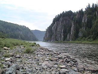
The Kija in Kuznetsk Alatau (near Moskowka, Tissul Rajon , Kemerovo Oblast ) |
||
The 548 km long Kija ( Russian Кия ) is a left tributary of the Chulym in central Siberia ( Russia , Asia ).
geography
The Kija flows from a small lake at an altitude of about 1250 m on the northern flank of the 1,489 m high Medweschja ("Bear Mountain") in Kuznetsk Alatau , in the east of Kemerovo Oblast, not far from the border with the Krasnoyarsk region . The river flows through the eastern part of the mountains in a narrow, rocky valley until it reaches the plain near the village of Tschumai. Here it continues its course in a north to north-westerly direction in a wide valley, now in sections strongly meandering . In its lower reaches, the river reaches Tomsk Oblast and finally flows into the Ob tributary Chulym above the village and district administrative center Syrjanskoje at an altitude of 99 m .
The main tributaries are the Tyashin ( Тяжин ) and Cheet ( Четь ) from the right and Kundat ( Кундат ), Koschuch ( Кожух ), Tschebula ( Чебула ) and Antibes ( Антибес ) from the left.
Hydrology
The catchment area of the Kija covers 32,200 km². The mean water flow in the village of Okuneevo, 34 kilometers above the mouth (and still above the confluence of the Cheet) is 167 m³ / s with a minimum monthly mean of 29.3 m³ / s in March and a maximum monthly mean of 773 m³ / s in May . Near the mouth, the kija is about 250 meters wide and 1.5 meters deep. The flow velocity here is 0.7 m / s.
The river freezes from November to April.
Economy and Infrastructure
The Kija was still considered navigable for smaller vessels from Mariinsk on the middle reaches in the 1980s ; Today only the lower reaches of 13 kilometers from Krasnoyarsky Reid is inland waterway, where the Cheet flows into it and a road crosses the river.
From the 1820s the region of the tributaries of the upper Kija (including Kundat, Mokry Berikul, Sukhoi Berikul) was an important gold mining area . Gold mining was scaled back from the beginning of the 20th century with relocation to the East Siberian extraction areas, but only came to a complete standstill in the 1990s (mine in the Berikulski settlement ). In operation, a is RUSAL's belonging nepheline tagebau (aluminum raw material) in Belogorsk on (Kijski) Schaltyr , a small tributary of the upper Kija (with station Kiya-Schaltyr , end point of a 1968 opened, 168 km long branch line of the railway Atschinsk - Abakan ).
There are only a few places on the mountain range of the Kija; the flat land section is more densely populated. The largest place here is the city of Mariinsk, where the Trans-Siberian Railway (on a 250 m long bridge) and the M53 highway from Novosibirsk to Irkutsk cross the river.
Individual evidence
- ↑ a b Article Kija in the Great Soviet Encyclopedia (BSE) , 3rd edition 1969–1978 (Russian)
- ↑ a b Kija in the State Water Register of the Russian Federation (Russian)
- ↑ a b Kija at the Okunejewo gauge - hydrographic data at R-ArcticNET
- ↑ Topographic map 1: 200,000 O-45-34 (1982, 1988 edition)
- ↑ List of Inland Waterways of the Russian Federation (confirmed by Order No. 1800 of the Government of the Russian Federation of December 19, 2002)
- ↑ G. Afonina: Kratkie svedenija o razvitii otečestvennych železnych dorog s 1838 po 1990 g. MPS, Moscow 1995 ( Brief information on the development of the national railways from 1838 to 1990 ; Russian).

