Kingston-Rhinecliff Bridge
Coordinates: 41 ° 58 ′ 39 " N , 73 ° 56 ′ 47" W.
| Kingston-Rhinecliff Bridge | ||
|---|---|---|
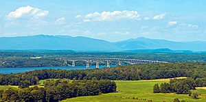
| View to northwest 2015, in the background the eastern foothills of the Catskill Mountains (Great Wall of Manitou) | ||
| Official name | George Clinton Memorial Bridge | |
| use |
|
|
| Crossing of | Hudson River | |
| place | Kingston and Rhinebeck | |
| Entertained by | New York State Bridge Authority | |
| construction | Truss bridge | |
| overall length | 2375 m | |
| Longest span | 244 m | |
| Clear height | 46 m ( HQ ) | |
| vehicles per day | 22,460 (2017) | |
| building-costs | US $ 17.5 million | |
| opening | 1957 | |
| planner |
David B. Steinman (superstructure) Carl H. Gronquist (substructure) |
|
| toll | 1.50 US $ (eastbound only) | |
| location | ||
|
|
||
The Kingston – Rhinecliff Bridge , officially the George Clinton Memorial Bridge , is a two-lane road bridge over the Hudson River between Kingston and Rhinebeck in New York State . It runs along New York State Route 199 and is operated by the New York State Bridge Authority ; the daily traffic volume averaged 22,460 vehicles in 2017.
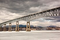
Opened in 1957, the bridge was originally planned as a suspension bridge between Kingston and Rhinecliff in the late 1940s based on a design by David B. Steinman . However, favoring a newly emerging IBM plant in the north of Kingston led to the delay in construction and ultimately to the relocation of the location six kilometers upstream. The further northerly location necessitated a modified design as a 1.6 kilometer long steel truss bridge . This is supplemented by girder bridges , making the structure almost 2.4 kilometers long. The largest spans of 244 meters each are located above the two outer fairways, which are separated here by a shoal in the middle of the river bed.
history
| ||||
Railway bridges |
With the construction of the Erie Canal , which from 1825 connected Lake Erie near Buffalo with the Hudson River near Troy , a trade route was created from New York City to the Great Lakes . This promoted the development of cities along the course of the river in the Hudson Valley and increasingly created the need for river crossings, which until the beginning of the 20th century were mostly only realized by ferry connections. The first bridges over the Lower Hudson were built between 1835 and 1888, largely by the expanding railroad companies in Troy, Albany and Poughkeepsie . The Poughkeepsie Bridge from 1888 is the only one still standing and has been a pedestrian bridge since 2009. With the expansion of the road network in the USA and the emergence of motorized individual transport, the need for road bridges increased from the 1920s. By 1935, the Bear Mountain Bridge (1924), Mid-Hudson Bridge (1930), George Washington Bridge (1931) and Rip Van Winkle Bridge (1935) were four major river crossings for road traffic, which are due to the width of The heavily trafficked Lower Hudson was mostly designed as a suspension bridge .
After World War II, the entrepreneur put Arthur H. Wicks from Kingston , who from 1927 to 1956 a member of the Senate from New York , was to build a bridge to Rhinecliff , which should replace the existing ferry service here. The next bridge over the Hudson was only about 30 kilometers away from Kingston to the south in Poughkeepsie (Mid-Hudson Bridge) or to the north in Catskill (Rip Van Winkle Bridge). In addition, the operator of the ferry connection ceased operations in the early 1940s, which in 1946 led to the takeover by the New York State Bridge Authority (NYSBA). In the following year, the bridge construction engineer David B. Steinman was commissioned to design a bridge, who worked out plans for a suspension bridge for the authority until October 1948. There was no official clearance for the next two years, and in 1950 the NYSBA requested a route further north, relocating the location six kilometers upriver. The reason was IBM's plans to build a new plant in the north of Kingston, which served as a production and development site from 1955 and employed up to 7,100 people in the coming decades. Steinman's engineering office then had to fundamentally revise the plans. The new location did not allow the construction of a suspension bridge with two pylons , as the Hudson forms two outer fairways here, which are separated by a shoal in the middle of the river bed. Finally, a truss bridge with several pillars was chosen as a design, which offered two large openings of over 200 meters for shipping. The first earthworks for the access roads began in July 1954 and the construction of the superstructure was completed at the end of 1956. Although it was opened to traffic at the beginning of February 1957, the official opening did not take place until May 11, 1957.
The reinforced concrete roadway already had cracks and potholes in the first year, which in 1958 led to the application of an additional asphalt surface . However, this had to be completely renewed in 1974 and 1984 and between 1997 and 2002 the entire reinforced concrete roadway was replaced and widened as part of an overhaul of the bridge. In 2000, in honor of the first Governor of New York and former Vice President of the USA George Clinton (1739-1812), the name was changed to George Clinton Memorial Bridge . The bridge is to become part of the hiking trail as part of the expansion of the 1200-kilometer Empire State Trail between Manhattan and Lake Champlain , for which a separate footpath will be installed on the south side of the roadway by the end of 2019.
description
The structure is divided into a central 1585 m long steel truss bridge, which is supplemented by entrances from girder bridges of around 340 m on the east side and 450 m on the west side. The total length between the abutments is 2375 m. The main bridge is divided into five trusses , which are supported by eleven reinforced concrete pillars up to 60 m high. It is constructed symmetrically to the central pillar and has a 91 m long single span girder on each outer side , followed by a 549 m long continuous girder over three bridge spans with spans of 152 m, 244 m and 152 m. In the middle, the bridge is closed by a continuous beam over two bridge fields with spans of 152 m. All girders are designed as strut frameworks with posts and lead the roadway on the top. The middle continuous beam and the two outer single-span beams have parallel upper and lower chords and a construction height of around 15 m. For the two outer continuous girders, curved lower chords were necessary to realize the large openings above the fairways, which almost doubled the construction height on four pillars.
The girder bridges of the access roads consist of 21 solid wall girders up to 46 m long and 3 m high , which rest on 19 further pillars and the abutments. After the widening, the reinforced concrete roadway now has a width of 12 m between the outer boundaries. It offers space for two 3.7 m wide lanes with hard shoulder, of which the southern one will be converted into a footpath 1.2 m wide for the Empire State Trail, separated by a concrete protective wall.
Web links
- The “George Clinton” Kingston-Rhinecliff Bridge. New York State Bridge Authority
Individual evidence
- ↑ Jack Howland: Backed up: As vehicles on local bridges increase, no relief in sight. Poughkeepsie Journal, October 22, 2018; accessed on September 8, 2019.
- ^ Donald E. Wolf: Crossing the Hudson: Historic Bridges and Tunnels of the River. Rutgers Univ. Press, 2010, ISBN 978-0-8135-4708-4 , pp. 3-6.
- ↑ Melissa Esposito: Kingston: The IBM Years Gives a Peek Into Tech Giant's History. Hudson Valley Magazine, June 4, 2014; accessed on September 8, 2019.
- ^ A b c Donald E. Wolf: Crossing the Hudson: Historic Bridges and Tunnels of the River. Rutgers Univ. Press, 2010, ISBN 978-0-8135-4708-4 , pp. 196-209.
- ^ A b c W. J. Moreau: Understanding the limitations of exodermic bridge decks: A case study on the Kingston-Rhinecliff Bridge. In: Khaled M. Mahmoud (Ed.): Safety and Reliability of Bridge Structures. CRC Press, 2009, ISBN 978-0-203-86158-5 , pp. 383-395.
- ↑ a b Katelyn Cordero: Pedestrian path on Kingston-Rhinecliff Bridge eyes early fall completion. Poughkeepsie Journal, Aug. 30, 2019; accessed on September 8, 2019.
- ^ Kingston-Rhinecliff Bridge (NY 199). NYCRoads; accessed on September 8, 2019.


