Kintyre (peninsula)
| Kintyre / Cinn Tire | |
 Mountains near the south coast of Kintyre in heather bloom |
|
| Geographical location | |
| Coordinates | 55 ° 30 ′ N , 5 ° 35 ′ W |
| Waters 1 | Atlantic Ocean |
| Waters 2 | Firth of Clyde |
| length | 77 km |
| width | 18 km |
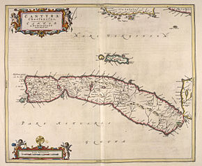
 Historical map from 1654 (east is below) |
|
The Kintyre Peninsula ( Scottish Gaelic Cinn Tìre , [kʲʰiɲˈtʲʰiːɾʲə] ) is an elongated peninsula in western Scotland in the Council Area Argyll and Bute or the traditional county of Argyll . This peninsula has the shortest connection to Northern Ireland , with a distance of 21 kilometers over the sea, Northern Ireland is within sight.
geography
The north of the peninsula is not part of the Kintyre Peninsula and is called Knapdale . There lies the port of Tarbert on the isthmus between West and East Loch Tarbert . To the west are the inhabited islands of Gigha and Islay and to the east the island of Arran . There are ferry connections to the three islands at least in summer.
Mull of Kintyre (Mull = cape, promontory) is the southern tip of the peninsula, where a lighthouse stands on the cliff. The place Southend on the southern tip is 77 kilometers by road from the north end in Tarbert.
history
It is believed that the Irish island was settled by hunters and gatherers , and later also by farmers via Kintyre.
On the barren peninsula are the prehistoric duns and forts Carradale, Dun Skeig, Dun Kildonan and Ranachan Hillfort , the stone row of Ballochroy and the Clyde Tomb of Blasthill near Southend. Campbeltown was a center of whiskey production in the late 19th century. Today there are only three distilleries left - Springbank , Glen Scotia and Glengyle .
traffic
Bus transport
A private company operates a bus route on the Kintyre Peninsula.
Air traffic
Flights operate between Glasgow and Campbeltown Airport .
Ferries
The following routes are served:
- Tarbert - Lochranza (Arran)
- Kennacraig - Port Ellen (Islay)
- Tayinloan - Gigha
- Tarbert - Portavadie
- Campbeltown - Ballycastle, Northern Ireland, summer only
- Campbeltown– Ardrossan , summer only
- Claonaig –Lochranza, only in summer
trail
The Kintyre Way long-distance hiking trail, opened in 2006, stretches for 141 kilometers from Tarbert at the northern end of the peninsula to Southend in the south. The marked path criss-crosses the peninsula.
Others
The song Mull of Kintyre by Paul McCartney and his band Wings describes the feeling of home when looking at the Mull of Kintyre.
The Mull of Kintyre Test was an unofficial rule of thumb for British film censors until 2003. After that, an erection in which a penis formed a higher angle to the vertical than the Kintyre Peninsula (which looks like a penis on a map) to the Scottish mainland could not be shown in any film .
