Koné (New Caledonia)
| Cone | |
|---|---|

|
|
| province | Northern Province |
| Aire coutumière | Paici-Camuki |
| Coordinates | 21 ° 4 ′ S , 164 ° 51 ′ E |
| height | 0-1,014 m |
| surface | 373.60 km 2 |
| Residents | 7,340 (August 26, 2014) |
| Population density | 20 inhabitants / km 2 |
| Post Code | 98860 |
| INSEE code | 98811 |
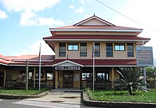
 Main street of Koné |
|
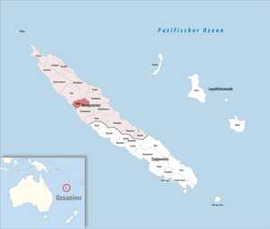
Koné is a commune in the Province of Nord in New Caledonia, France .
geography
Koné is located on the humid west coast of the largest New Caledonian island of Grande Terre and also includes the Île Pingiane off the coast. Inland, the community is characterized by mountains that rise to 1041 m. The highest point of the municipality is at 1014 m near the summit of Atheu.
Koné has a small airport, which is located around 2 km from the city center.
Districts
In addition to Koné as the largest district, Koniambo and Tiaoué as the smallest settlements belong to the municipality. A total of ten different tribes live in the Konés area.
history
The Lapita site (probably 21 ° 6 ′ 0 ″ S , 164 ° 48 ′ 30 ″ E ) of the first arable and ceramic producing Lapita culture (from 1500 BC) in Melanesia is located on the Foué peninsula not far from Koné . The oldest traces of a settlement on New Caledonia were discovered here in 1917. It consisted of round and oval houses and was built around 1400–1200 BC. Inhabited.
Koné was founded as a military base in 1879 and received city rights in 1887. For several years now, the city has been expanding into an industrial and school center as planned, which is to form a counterpoint to the capital Nouméa in northern New Caledonia. The Usine du Nord factory for nickel processing was recently built in neighboring Voh , and by 2015 the three towns of Koné, Voh and Pouembout in the south are to form an agglomeration of 16,000 inhabitants.
population
| Population development in Koné (2009 estimated) | |||||||||
|---|---|---|---|---|---|---|---|---|---|
| Residents | 2037 | 2340 | 2557 | 2479 | 2919 | 2919 | 4088 | 4500 | 4845 |
| year | 1956 | 1963 | 1969 | 1976 | 1983 | 1989 | 1996 | 2004 | 2009 |
Attractions
The town hall was inaugurated at the end of 2006. Inside, frescoes and sculptures by local artist Kiki Poma are noteworthy. Not far from there, a memorial commemorates the New Caledonians from Koné and the surrounding area, who lost their lives for France in the First and Second World Wars.
The catholic church, visible from afar, with its distinctive triangular shape and a gable turret in place of a church tower was inaugurated in 1954, it goes back to a mission station founded in 1891.
The open-air museum and cultural center Center culturel provincial de Koohnée , which consists of a manorial country house built around 1880 and several traditional huts from various tribes, is located about 3 km southeast of the city center not far from the Koné River. Plays, films and concerts are also performed here.
Individual evidence
- ↑ Christophe Sand: Archeology in New Caledonia , p. 29. Nouméa 1993
- ↑ a b Pierre Grundmann: Nouvelle Calédonie , p. 128. Paris 2012
- ↑ a b Pierre Grundmann: Nouvelle Calédonie , p. 127. Paris 2012
- ↑ Population development in Koné 1956–2009 ( page no longer available , search in web archives ) Info: The link was automatically marked as defective. Please check the link according to the instructions and then remove this notice.


