Le Mont-Dore
| Le Mont-Dore | |
|---|---|

|
|
| province | Southern province |
| Aire coutumière | Djubéa caponé |
| Coordinates | 22 ° 13 ′ S , 166 ° 28 ′ E |
| height | 0-825 m |
| surface | 643.0 km 2 |
| Residents | 27,155 (August 26, 2014) |
| Population density | 42 inhabitants / km 2 |
| Post Code | 98809, 98810 |
| INSEE code | 98817 |
Le Mont-Dore is a municipality in the southern province in New Caledonia .
Le Mont-Dore is the second largest city of New Caledonia and focus of a joint community ( commune ). It is very extensive in terms of area and is mostly located on the main island of Grande Terre , but also other small islands off the coast, such as the Île Ouen , are part of it. Mont-Dore is a young city. It was created in 1970 by merging the towns of La Capture, La Conception (?), La Coulée, Mont-Dore (main town), Ouara (Nouvelle-Calédonie), Plum (Nouvelle-Calédonie), Prony (Nouvelle-Calédonie) and Saint-Louis (Nouvelle-Calédonie). It borders directly on the capital Nouméa and thus belongs in part to the greater Nouméa area.
population
| 1956 | 1963 | 1969 | 1976 | 1983 | 1989 | 1996 | 2004 |
|---|---|---|---|---|---|---|---|
| 1,288 | 2,640 | 4,809 | 10,659 | 14,614 | 16,370 | 20,780 | 24,195 |
Attractions
- The most important sight of the city is the pilgrimage church Eglise de la Conception , built in 1874 , which rises on the site of a mission station founded in 1855. Every year there is a pilgrimage here on the Assumption of Mary. On the dome of the square bell tower is a statue of the Virgin Mary, 2.80 m high, visible from afar and modeled on the Notre-Dame de Fourvière church in Lyon . The facade of the much-visited church was redesigned in 1893.
- Another church worth visiting was built in 1860 in Saint-Louis, a district of Le Mont-Dore 6 km to the east. A mission station was founded here in 1856, which was moved to the location of the current church in 1859. The church with its red corrugated iron roof can also be seen from afar, around it the buildings of the former mission station are well preserved.
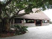
- In the center of Le Mont-Dore, which is being built in the Boulari district, is the town hall ( Mairie ), whose architectural style is largely based on the colonial style. An outbuilding was built in the traditional Melanesian style, with a roof made of palm leaves and an oval floor plan, with carved totem poles.
- The Place des Accords was laid out next to the town hall - a large, free square open to the sea with a memorial to the victims of the two world wars. The marina adjoins the square and a city park is planned next to it.
- Also in the center of LeMont-Dore is the modern cultural center ( Center Culturel ), next to which there are extensive sports facilities. A small park has been created around the cultural center with carved totem poles in the traditional style, but also with sculptures in a more modern style based on the traditional art of the Melanesians.
Surroundings
In the east of the city rises the 772 m high Mont Dore, from which there is a beautiful view of the small, offshore islands of Bailly and Charron. The district of Plum is located on the picturesque bay of Baie de Monéa .
Web links
Individual evidence
- ↑ World Gazetteer ( page no longer available , search in web archives ) Info: The link was automatically marked as defective. Please check the link according to the instructions and then remove this notice.
- ↑ Pierre Grundmann: Nouvelle Calédonie , p. 88. Paris 2012
- ↑ Pierre Grundmann: Nouvelle Calédonie , p. 89. Paris 2012


