
Kostrzyn
| Kostrzyn | |||
|---|---|---|---|

|
|
||
| Basic data | |||
| State : | Poland | ||
| Voivodeship : | Greater Poland | ||
| Powiat : | Poznański | ||
| Gmina : | Kostrzyn | ||
| Area : | 8.03 km² | ||
| Geographic location : | 52 ° 24 ' N , 17 ° 13' E | ||
| Residents : | 9674 (June 30, 2019) | ||
| Postal code : | 62-025 | ||
| Telephone code : | (+48) 61 | ||
| License plate : | PZ (formerly also POZ) | ||
| Economy and Transport | |||
| Street : | Poznan - Września | ||
| Rail route : | Warsaw – Poznan | ||
| Next international airport : | Poznan-Ławica | ||

Kostrzyn ( German Kostschin ) is a city in the Powiat Poznański of the Greater Poland Voivodeship in Poland . It is the seat of the town-and-country municipality of the same name with 18,353 inhabitants (as of June 30, 2019).
Geographical location
Kostrzyn is located 21 kilometers east of the city of Poznan . The village is on the state road 92 and on the Berlin - Warsaw railway line .
history


In a document from the year 1251 is that the Grand Duke Przemysl I. the city Kostrzyn city rights analogous to the City Rogoźno (Rogasen) issued.
In 1331 the city, which was not surrounded by walls, was ravaged and ravaged by the Teutonic Knights . In the 15th century the city was the seat of the Starosts ; In 1441 Lukas Gorka is called capitaneus Costrzenensis .
In 1793 the city fell to Prussia. After the First World War , the city had to be ceded to the Second Polish Republic due to the provisions of the Versailles Treaty . With the attack on Poland in 1939, the city was annexed by the German Reich in violation of international law. The city was incorporated into the Schroda district in the Reichsgau Wartheland .

Catholic Church
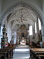
Interior of the church

Altar of the church


Towards the end of the Second World War , Kostschin was occupied by the Red Army in the spring of 1945 . The German part of the population was expelled in the period that followed .
A memorial was erected on the market square in honor of the 28 inhabitants of Kostrzyn who were executed on October 20, 1939 as part of the Tannenberg company . The murders took place with the active support of the local German minority (see also Volksdeutscher Selbstschutz ).
Population figures before 1945
- 1800: 660 (Poland), including 14 Jews
- 1837: 1178
- 1861: 1700
- 1875: 2050
- 1880: 2090
- 1890: 2117, including 192 Protestants and 41 Jews (1700 Poles)
local community
The town itself and 20 villages with school administration offices belong to the town-and-country community (gmina miejsko-wiejska) Kostrzyn.
Culture and sights
The architectural monuments include the late Gothic church of the Holy Apostles Peter and Paul from the 16th century and the town houses along Średzka Street from the 18th century (house numbers 30 and 35) and from the 19th century (house numbers 2 and 4).
Personalities
- Bogdan Frankiewicz (1923–2003), Polish archivist and historian.
literature
- Heinrich Wuttke : City book of the country Posen. Codex diplomaticus: General history of the cities in the region of Poznan. Historical news from 149 individual cities . Leipzig 1864, p. 341.
Web links
Footnotes
- ^ A b c d e Heinrich Wuttke : City book of the country of Posen. Codex diplomaticus: General history of the cities in the region of Poznan. Historical news from 149 individual cities . Leipzig 1864, p. 341.
- ^ A b c Michael Rademacher: German administrative history from the unification of the empire in 1871 to the reunification in 1990. pos_schroda.html. (Online material for the dissertation, Osnabrück 2006).