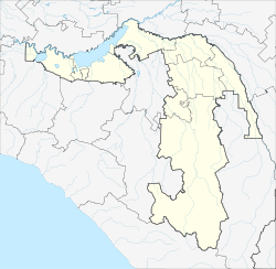
Krasnogwardeiskoje (Adygeja)
Village
|
||||||||||||||||||||||||||||||
|
||||||||||||||||||||||||||||||
|
||||||||||||||||||||||||||||||
Krasnogvardeyskoye ( Russian Красногвардейское ; Adyghe Красногвардейскэ ) is a village (selo) in the Republic of Adygea ( Russia ) with 9459 inhabitants (as of October 14, 2010).
geography
The place stretches for more than 8 km along the southeast bank of the Krasnodar reservoir of the Kuban , about 70 km as the crow flies northwest of the republic capital Maikop .
Krasnogvardeyskoye is the administrative center of the Rajons Krasnogwardeiski and seat of the rural community Krasnogvardeyskoye selskoje posselenije, to which apart from the village nor the Aul Adami and the hamlet (Khutor) Chumakov belong.
history
The place was founded under the name Nikolajewskoje in 1884. In the 1930s the village of Solovyovskoye was annexed. On November 11, 1961, Nikolayevskoye was united with the village of Ivanovskoye and, like the Rajon, received its current name, from Krasnaya Gwardija, Russian for Red Guard .
Population development
| year | Residents |
|---|---|
| 1939 | 1693 |
| 1959 | 3591 |
| 1970 | 7499 |
| 1979 | 8406 |
| 1989 | 8798 |
| 2002 | 9065 |
| 2010 | 9459 |
Note: census data
traffic
The regional road R253 runs past the town to the east and connects the city of Ust-Labinsk , located just under 10 km to the northeast, in the neighboring Krasnodar region with Belorechensk and Maikop. Ust-Labinsk also has the nearest rail connection on the Kawkasskaya ( Kropotkin ) - Krasnodar line .
Individual evidence
- ↑ a b Itogi Vserossijskoj perepisi naselenija 2010 goda. Tom 1. Čislennostʹ i razmeščenie naselenija (Results of the All-Russian Census 2010. Volume 1. Number and distribution of the population). Tables 5 , pp. 12-209; 11 , pp. 312–979 (download from the website of the Federal Service for State Statistics of the Russian Federation)

