Tachtamukai
Aul
|
||||||||||||||||||||||||||||||
|
||||||||||||||||||||||||||||||
|
||||||||||||||||||||||||||||||
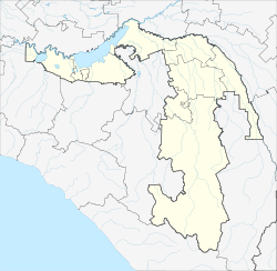
Tachtamukai ( Russian Тахтамукай ; Adygeic Тэхъутэмыкъуай ) is an Aul in the Republic of Adygeja ( Russia ) with 5214 inhabitants (as of October 14, 2010).
geography
The place is about 100 km as the crow flies northwest of the republic capital Maikop and about 15 km south of the center of Krasnodar , the center of the neighboring Krasnodar region , on the eastern bank of the small Oktyabrskoye reservoir of the Sup, a left tributary of the Kuban, which flows a few kilometers to the north .
Takhtamukay is the administrative center of the Rajons Tachtamukaiski and seat of the rural community Tachtamukaiskoje selskoje posselenije, to the non Takhtamukay nor the Aul Natuchai, the settlements Otradny, Prikubanski and Sups and the hamlet (Khutor) include Apostolidi.
history
The Aul was founded in 1860 and was initially called Enemski or Enem-Tachtamukai until 1870 . In the 1930s he was briefly called (1936–1938) Chakurate, after the Adygeic revolutionary and Soviet functionary Schachan -Girei Chakurate (1883–1935). On August 5, 1957, it was renamed Oktjabrski, after Russian oktjabr for October, with reference to the October Revolution . The Adygeic name was restored in the 1990s.
Population development
| year | Residents |
|---|---|
| 1939 | 3223 |
| 1959 | 3165 |
| 1970 | 4419 |
| 1979 | 4907 |
| 1989 | 5212 |
| 2002 | 5117 |
| 2010 | 5214 |
Note: census data
traffic
From Tachtamukai there is a road connection to the significantly larger settlements in Rajon, Enem and Jablonowski, a few kilometers to the west and north-west . The railway line Krasnodar - Novorossiysk and the following trunk road A146, which is also part of the European route 115, run through this . To the east there is a connection to the city of Adygeisk at the southwest end of the Krasnodar reservoir , on the M4 highway .
Individual evidence
- ↑ a b Itogi Vserossijskoj perepisi naselenija 2010 goda. Tom 1. Čislennostʹ i razmeščenie naselenija (Results of the All-Russian Census 2010. Volume 1. Number and distribution of the population). Tables 5 , pp. 12-209; 11 , pp. 312–979 (download from the website of the Federal Service for State Statistics of the Russian Federation)

