Koschechabl
Aul
|
||||||||||||||||||||||||||||||||||||||
|
||||||||||||||||||||||||||||||||||||||
|
||||||||||||||||||||||||||||||||||||||
Koshekhabl ( Russian Кошехабль , Adyghe Кощхьабл ) is Aul in the Republic of Adygea ( Russia ) with 7239 inhabitants (as of October 14, 2010).
geography
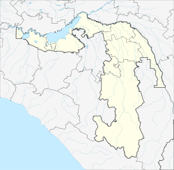
The place is located in the foothills of the western Great Caucasus about 45 kilometers as the crow flies northeast of the republic capital Maikop on the left bank of the Kuban tributary Laba . Across the river that marks the border with the Krasnodar Territory , the city of Kurganinsk is just five kilometers away (center) .
Koshekhabl is the administrative center of the Rajons Koschechablski . 84% of the population are Adyge , 13% Russian .
history
The place was founded by Kabardians who fled from the Caucasus War of 1817–1864 , who had previously stayed in different parts of the area, but had to change them several times due to the floods of the Laba. In 1868 they were assigned the current location. The current name of the place originally called Ansauri , which in the Adygeic language means a settlement that changes place, refers to the history of the establishment.
During the Soviet period, on December 28, 1934, the Aul became the administrative seat of a newly founded Rajon. During the Second World War , Koschechabl was occupied by the German Wehrmacht from August 1942 to January 1943 .
Population development
| year | Residents |
|---|---|
| 1939 | 3624 |
| 1959 | 5391 |
| 1970 | 6529 |
| 1979 | 6601 |
| 1989 | 6935 |
| 2002 | 7309 |
| 2010 | 7239 |
Note : census data
Economy and Infrastructure
Koschechabl is the center of an agricultural area in which wheat, corn, sunflowers, tobacco, tea, fruit and vegetables are grown and cattle, sheep and horses are raised.
The settlement is located on the single-track, electrified railway line Armavir - Tuapse of the North Caucasian Railway (route km 1700 from Moscow ; km 48 from Armavir). The regional road R 256 runs through the village, which , starting from Maikop via Giaginskaya and Schowgenowski , opens up the central part of the republic to the left of the Laba and continues past the city of Labinsk through the neighboring Krasnodar region to the republic of Karachay-Cherkessia , where it leads south of Ust-Dscheguta ends on the A155 trunk road .
Sons and daughters of the place
- Tembot Keraschew (1902–1988), Adygean writer
- Mucharbi Kirschinow (* 1949), weightlifter, Olympic champion 1972
Individual evidence
- ↑ a b Itogi Vserossijskoj perepisi naselenija 2010 goda. Tom 1. Čislennostʹ i razmeščenie naselenija (Results of the All-Russian Census 2010. Volume 1. Number and distribution of the population). Tables 5 , pp. 12-209; 11 , pp. 312–979 (download from the website of the Federal Service for State Statistics of the Russian Federation)
- ↑ History of the Rajons ( page no longer available , search in web archives ) Info: The link was automatically marked as defective. Please check the link according to the instructions and then remove this notice. on the website of the place (Russian)
- ↑ Giaginskaja on the website of the Geographical Institute of the RAN (Russian)
Web links
- Official website of the local government (Russian)

