Kropotkin (Krasnodar)
| city
Kropotkin
Кропоткин
|
||||||||||||||||||||||||||||||||||||||||
|
||||||||||||||||||||||||||||||||||||||||
|
||||||||||||||||||||||||||||||||||||||||
| List of cities in Russia | ||||||||||||||||||||||||||||||||||||||||
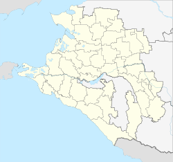
Kropotkin ( Russian Кропо́ткин ) is a city with 80,765 inhabitants (as of October 14, 2010) in Russia . It is located in the Krasnodar region on the Kuban River , about 1,200 km as the crow flies south-southeast of Moscow and 136 km northeast of the subject capital Krasnodar .
history
Since the end of the 18th century there was a military outpost of the Russian Empire on the site of today's city of Kropotkin . A workers' settlement called Romanowski was built during the construction of a railway line towards the Caucasus . The railway line was opened on June 18, 1874; this date is considered by some city historians to be the founding date of today's city of Kropotkin.
In 1921 the place received city rights and was named after the anarchist Prince Pyotr Kropotkin, who had died shortly before . At the same time, Kropotkin became the administrative center of a raion within the Krasnodar region. In the 1920s and 1930s, the city was expanded: a number of factories, three power plants and various public facilities were built. From 1924 to 1933 the agricultural test area of the German-Russian Saatbau AG ( DRUSAG ) was located near Kropotkin .
During World War II , Kropotkin was occupied by the German Wehrmacht from August 1942 to January 1943 . The city suffered considerable damage, and around 2000 residents were killed.
In the post-war years, the city's most important industrial plants were rebuilt and new ones built. In the 1970s and 1980s, a new industrial area was built on the outskirts.
Population development
| year | Residents |
|---|---|
| 1926 | 31,000 |
| 1939 | 41,538 |
| 1959 | 53,997 |
| 1970 | 68,339 |
| 1979 | 70,218 |
| 1989 | 75,929 |
| 2002 | 79.185 |
| 2010 | 80,765 |
Note: census data (1926 rounded)
Economy and Transport
Kropotkin is considered an important center of the food industry in the Krasnodar Territory. There are also processing companies in the chemical industry, mechanical engineering and the building materials industry in the city.
The city plays an important role as a railway junction: the Rostov-on-Don - Baku and Stavropol - Krasnodar routes intersect in the Kropotkins area . There is also a campus of the Rostov Transport University in the city. The main road connection to Kropotkins is via the trunk road R217 .
Culture and sights
- Barrows from the Bronze Age
- Historic city center from the 19th and early 20th centuries:
- Cathedral of the Mother of God Protection and Intercession
- Station building (1903)
- Victory Park and War Memorials
sons and daughters of the town
- German Lupekin (1919–2016), theater and film actor and director
- Gennady Kovalyov (born 1983), boxer
Individual evidence
- ↑ a b Itogi Vserossijskoj perepisi naselenija 2010 goda. Tom 1. Čislennostʹ i razmeščenie naselenija (Results of the All-Russian Census 2010. Volume 1. Number and distribution of the population). Tables 5 , pp. 12-209; 11 , pp. 312–979 (download from the website of the Federal Service for State Statistics of the Russian Federation)
Web links
- City Council website (Russian)
- Website of the Kawkasski district administration (with Kropotkin) (Russian)
- Kropotkin on mojgorod.ru (Russian)


