
Eastern knot tip
| Eastern knot tip | ||
|---|---|---|
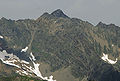
 Kreuzspitze (left) and Ostliche Knotenspitze (right) from the southeast |
||
| height | 3101 m above sea level A. | |
| location | Between the Falbeson Valley and the Oberbergtal | |
| Mountains | Stubai Alps | |
| Dominance | 0.57 km → Falbesoner Knotenspitze | |
| Notch height | 68 m ↓ notch to the Falbesonder knot tip | |
| Coordinates | 47 ° 3 '52 " N , 11 ° 10' 57" E | |
|
||
| Type | Rock peaks | |
| rock | Granite gneiss | |

The eastern node tip is a 3101 m above sea level. A. high mountain in the Stubai Alps in the Austrian state of Tyrol . The Kreuzspitze ( 3,084 m ) is more important for tourism than the main summit , a secondary summit about 100 meters to the southwest, which also bears the summit cross .
topography
The Eastern Knotenspitze is part of a long ridge between the Falbeson Valley in the southeast and the Oberbergtal in the northwest, two side valleys of the Stubai Valley . Neighboring peaks are the Falbesoner Knotenspitze ( 3118 m ) in the southwest and the Uelasgratspitze 3038 m in the northeast. In addition to the main ridge, which runs from the Falbesoner Knotenspitze over the Kreuzspitze and the eastern Knotenspitze to the Uelasgratspitze, the Östliche Knotenspitze sends out a pronounced ridge towards the northwest, the Gschwezgrat , which separates the Kare Stiergschwez in the west and Kuhgschwez in the east. Another ridge runs from the Kreuzspitze towards the southeast.
The mountain has mostly rocky character, the southern flank is characterized by steep grass and craggy terrain. In the northwest there is a small glacier , the Knotenspitzferner , and two other small ice fields extend in the southwest ( Jedlasgrüblferner ) and northeast ( Gugeliger Ferner ).
ways
The normal route leads on a partially insured, marked trail from the Neue Regensburger Hütte in the Falbesoner Tal through the Jedlasgrübl and the southern flank to the summit of the Kreuzspitze. The main summit can be reached from there via a small notch and a narrow block ridge without a path in the II. Degree of difficulty (UIAA) .
Further climbs are possible via the southeast ridge (UIAA I-II), the Gschwezgrat (UIAA II, first ascended in 1890 by Ludwig Purtscheller ), the ridge from the Uelasgratspitze (UIAA IV) and from the Falbesoner Knotenspitze (UIAA I). In winter, the Kreuzspitze can be climbed as a ski tour . For this purpose, the ascent from the north from the Franz-Senn-Hütte is usually chosen, which leads through the Stiergschwez and over the Knotenspitzferner through a steep gully to the notch between the Kreuzspitze and the main summit. From the Neue Regensburger Hütte, you can ski up the Gugeligen Ferner.
literature
- Heinrich and Walter Klier : Alpine Club Guide Stubai Alps . Bergverlag Rother , Munich 1980, ISBN 3-7633-1212-9 , p. 311-312 .
photos
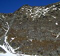
The rugged southern flank of the Kreuzspitze
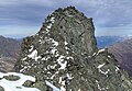
The main peak of the Eastern Knot Tip as seen from the Kreuzspitze

Eastern node point (left) and cross point (right) from the north
From the south-east ( Inner Wetterspitze ): Left Kreuzspitze, right Eastern Knotspitze


Individual evidence
- ↑ Alpine Club Card 31/1 Stubai Alps, Hochstubai
- ↑ Compass hiking, bike and ski tour map No. 83 (Stubai Alps)