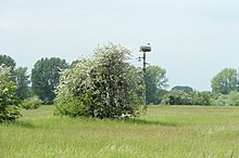
Landscape protection area Obere Leine

The conservation area Upper leash is about 1200 ha large landscape conservation area in the cities of Hemmingen , Laatzen and Pattensen within the Hanover region . It bears the official identification LSG H 21. To the north borders a landscape protection area of the same name in Hanover with the identification LSG HS 04.
location
The landscape protection area is located in the valley of the Leine between the natural areas of the Calenberg and the Hildesheimer Börde . In the north it extends to the regional border with the city of Hanover near Hemmingen and in the south to the border with the district of Hildesheim near Koldingen . The area is about 9 km long and up to 3 km wide. The 317 hectare Alte Leine nature reserve is enclosed by the Obere Leine nature reserve .
description
The landscape protection area is characterized by the numerous river loops of the Leine and its roughly parallel old arm, the Alte Leine . Typical for the landscape are riparian trees with pollarded willows and alders along the rivers. The numerous ponds created by gravel extraction within the protected area, which are often used as fish ponds, are characteristic. The Leine masch , located in the floodplain area of the rivers, is used for water extraction and is used extensively as grassland . The few remaining forest remnants have lost their floodplain and quarry forest character . The landscape protection area is a habitat for typical animal and plant species.
The area is divided into two protection zones with different degrees of protection. In protection zone I there are flowing waters and their floodplains with still waters, riparian zones, grassland areas, trees and bushes, fallow areas and the terrace edges of the Leine. Protection zone II comprises the areas in which arable and recreational uses predominate.
It was placed under protection in 2000.
Gravel mining
In the valley of the Leine between Hanover and Nordstemmen , numerous ponds have emerged over the course of time through gravel extraction. There are a number of as yet undeveloped raw material deposits of gravel and sand within the landscape protection area Obere Leine. Their exploitation is fundamentally prohibited according to the Landscape Protection Area Ordinance. In some defined " priority areas of raw material extraction", soil extraction is still possible to secure the raw material supply. There the concerns of landscape protection take precedence over the concerns of raw material extraction.
Roman camp in the gravel mining area
In 2015, artefacts were identified in the Obere Leine landscape protection area between Arnum and Wilkenburg as remains of the 2000 year old and 30 hectare Roman marshal from Wilkenburg , after there was evidence of such a facility in the 1990s. On the part of the Lower Saxony State Office for Monument Preservation , the marching camp is rated as a ground monument of European importance.
The site is located on two 16 and 17 hectare areas, for which Holcim submitted applications for mining gravel and sand in 2014. These are areas in "priority areas of raw material extraction", which are referred to as "1st order deposit" in the regional spatial planning program Region Hannover (RROP). A plan approval procedure for gravel mining has been running in the Hanover region since 2015 . As of September 2016, there were 28 statements from municipalities, associations and public bodies as well as around 250 objections from private individuals. In addition to the monument protection for the Roman camp, it deals with the issues of nature , species , noise and flood protection , taking into account a flood of the century . A decision by the Hanover region on the approval or refusal of the dismantling is expected in summer 2017.
See also
Web links
- Landscape protection area ordinance of the city of Laatzen (LSG-H 21) from 1992
Individual evidence
- ↑ Answer of the Hanover region of August 16, 2016 to the request of the Bündnis 90 / Die Grünen parliamentary group in the Hemmingen City Council on the planning approval procedure for the planned gravel mining in the Müggenwinkel / Wilkenburg area (pdf)
Coordinates: 52 ° 18 ′ 21 ″ N , 9 ° 45 ′ 13 ″ E

