
Lauca National Park
| Lauca National Park | |||
|---|---|---|---|
 |
|||
|
|||
| Location: | Arica y Parinacota , Chile | ||
| Surface: | 1,370 km² | ||
| Founding: | 1965 | ||

The Lauca National Park (span. Parque Nacional Lauca ) is the northernmost national park in Chile and biosphere reserve of UNESCO .
location
It begins about 12 km east of the town of Putre in the Región de Arica y Parinacota , Provincia de Arica , close to the border with Bolivia and covers around 1300 square kilometers. The administrative headquarters are in Parinacota .
climate
During the day it is relatively pleasant at 5–20 ° C, whereas the nights are often very cold (down to −15 ° C). In the highlands there is dry grassland, but also more humid areas. The extreme altitude of the park and the thin mountain air can cause physical complaints for park visitors.
topography
The national park is shaped by the Andes mountain range. Huge mountains and volcanoes with up to 6300 m surround the park. The many volcanoes, mostly six-thousanders, are striking.
- Volcán Parinacota with 6342 m height
- Volcán Pomerape at 6286 m altitude
- Volcán Guallatire with 6071 m height
- Cerro Acotango with 6052 m height
Lake Chungará is located near the volcanoes at an altitude of 4520 m. The approximately 21 km² lake is one of the highest lakes in the world. In Jurasi you can visit the hot springs and learn about the culture of the indigenous people in the village of Parinacota . Other attractions include climbing and fishing tours. The park is managed by CONAF , the Chilean forest authority. From the Laguna Parinacota, water is discharged through a channel towards the dry coastal region. The main rivers are the Río Lauca and the Río Lluta .
Wildlife
The national park offers a rich fauna, including z. B. also guanacos , vicuñas and fork deer . In addition, around 140 different bird species live in the park, which is located at altitudes between 4000 and over 6000 m. Andean condors , pumas, and vizcachas are other residents of the park.
In the south of the adjacent protected area Reserva nacional Las Vicuñas (another 2000 square kilometers) lies the large salt lake Salar de Surire at 4245 m with its thermal springs . Here you can watch flamingos , vicuñas and llamas . The Monumento Natural Salar de Surire was established in 1983 and covers around 175 km².
photos

Vicuñas
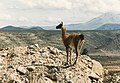
Guanaco in Lauca National Park

View over Lake Chungará at sunrise

Alpacas with hoarfrost on their backs
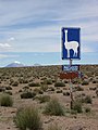
Road sign


swell
- ↑ Philip W. Rundel, Beatriz Palma: Preserving the Unique Puna Ecosystems of the Andean Altiplano: A Descriptive Account of Lauca National Park, Chile . In: Mountain Research and Development . 20, No. 3, August 2000, pp. 262-271. doi : 10.1659 / 0276-4741 (2000) 020 [0262: PTUPEO] 2.0.CO; 2 . Retrieved September 24, 2007.
Web links
Alberto de Agostini | Alerce Andino | Alerce Costero | Bernardo O'Higgins | Bosque de Fray Jorge | Chiloe | Conguillío | Corcovado | Hornopirén | Huerquehue | Isla Guamblin | Isla Magdalena | Juan Fernández Archipelago | Cape Horn | La Campana | Laguna del Laja | Laguna San Rafael | Las Palmas de Cocalán | Lauca | Llanos de Challe | Llullaillaco | Morro Moreno | Nahuelbuta | Nevado Tres Cruces | Pali Aike | Pan de Azúcar | Puyehue | Queulat | Radal Siete Tazas | Rapa Nui | Salar del Huasco | Tolhuaca | Torres del Paine | Vicente Pérez Rosales | Villarrica | Volcán Isluga