Lauenhain (Mittweida)
|
Lauenhain
City of Mittweida
Coordinates: 51 ° 0 ′ 9 ″ N , 12 ° 58 ′ 1 ″ E
|
||
|---|---|---|
| Residents : | 844 (2014) | |
| Incorporation : | January 1, 1994 | |
| Incorporated into: | Lauenhain-Tanneberg | |
| Postal code : | 09648 | |
| Area code : | 03727 | |
|
Location of Lauenhain in Saxony |
||
Lauenhain is a district of the large district town of Mittweida in the Saxon district of Central Saxony . In 1994 it was merged with Tanneberg to form the municipality of Lauenhain-Tanneberg, and in 1999 it was incorporated into the city of Mittweida.
geography
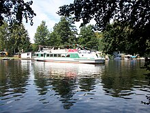
Lauenhain is located north of Mittweida in the central Saxon hill country west of the Zschopau dammed up to the Kriebstein dam . Towards Zschopau, the terrain drops off quite steeply. There is the landing stage for excursion boats on the Kriebstein Dam, as well as several facilities for gastronomy and water sports.
Neighboring places
| Erlau | Tanneberg | Falcon Grove |
| Erlau |

|
Ringethal |
| Mittweida | Rößgen |
history
In a document from May 18, 1293, the Lewinhayn mill and "dy Lewinheynische Bach" were mentioned. This is the first documentary mention of the Waldhufendorf Lauenhain. At that time, the place was already an exclave of the Altzella monastery . This only changed after the secularization and dissolution of the monastery in 1540. Four years later, Lauenhain came as an exclave to the newly formed electoral-Saxon office of Nossen . Lauenhain was surrounded by the Rochlitz office and exclaves of other offices. In 1836 the place was subordinated to the Office of Frankenberg-Sachsenburg . The offices were dissolved during the administrative reforms carried out in the Kingdom of Saxony in the 19th century . As a result, Lauenhain came under the administration of the Mittweida court office in 1856 . In 1875 the place was subordinated to the administration of the administrative authority Rochlitz . With the construction of the Kriebstein dam between 1927 and 1929, the Lauenhainer mill in the Zschopau valley was demolished. Today, there are several restaurants and water sports facilities on the Lauenhain bank of the dam next to the ship pier.
As a result of the second district reform in the GDR in 1952, Lauenhain became part of the Hainichen district in the Chemnitz district (renamed the Karl-Marx-Stadt district in 1953 ), which was continued as the Saxon district of Hainichen from 1990 onwards . ei the administrative reform that took place in 1994, the place was merged with the neighboring Tanneberg to form the municipality of Lauenhain-Tanneberg and assigned to the newly formed Mittweida district . On January 1, 1999, the municipality Lauenhain-Tanneberg was voluntarily incorporated into the city of Mittweida. Due to the main statute of the city of Mittweida from 1994, the current districts of Lauenhain and Tanneberg received a joint local constitution and a joint local council. Since 2008, the city of Mittweida and its districts have been part of the newly formed Central Saxony district .
Development of the population
|
|
|
religion
Lauenhain already belonged to Mittweida around 1555. Today the Protestant church members belong to the Evangelical Lutheran parish Mittweida.
Economy and Transport
Lauenhain was an agricultural farming village until the beginning of the 20th century. In the course of industrialization, several single and multi-family houses for workers in the nearby town of Mittweida were built between 1924 and 1927.
There is a connection to the Riesa – Chemnitz railway in Mittweida and in the neighboring town of Erlau .
Attractions
- Kriebstein dam : between 1927 and 1929, the Kriebstein dam was built near the village by damming the Zschopau. Lauenhain, which borders the upper end of the dam, has several landing stages for motor boats and, during the season, a boat ferry connection to Ringethal. Furthermore, during the season there is the possibility of taking motorboat trips to Kriebstein and the Mittweidaer Aue or tours across the Zschopau.
- Nature trail over the heraldic rock, past the Tanneberg rock fall to the reservoir
- Zschopautal area hiking and cycling path through the landscape protection area "Kriebstein Dam"
Web links
- Lauenhain in the Digital Historical Directory of Saxony
- History of Lauenhain on the homepage of the city of Mittweida
- Homepage of the Kriebstein dam with the ferry connections to Lauenhain and tips for excursions around Lauenhain
- History & pictures of the Lauenhainer mill
Individual evidence
- ↑ Mittweida in figures , accessed on July 31, 2014
- ^ Karlheinz Blaschke , Uwe Ulrich Jäschke : Kursächsischer Ämteratlas. Leipzig 2009, ISBN 978-3-937386-14-0 ; P. 70bsp; f.
- ^ History of the town of Lauenhain on www.suender.org
- ↑ The locations of the Frankenberg-Sachsenburg office in the 19th century in the "Handbuch der Geographie", p. 63
- ^ The Rochlitz district administration in the municipal register 1900
- ↑ Website of the Kriebstein dam
- ↑ Lauenhain on gov.genealogy.net
- ↑ Timetable of the passenger ships on the Kriebstein dam
- ↑ Hiking trails at the Kriebstein dam on the reservoir's homepage


