Lauragais
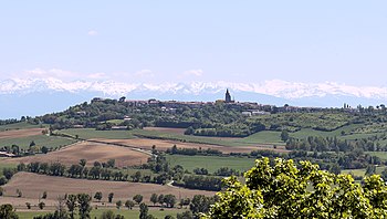
The Lauragais or Lauraguais ( Occitan : Lauragués ) is the name of a landscape in southwest France , southeast of Toulouse . The area is also known in France as the Pays de Cocagne (" Land of plenty "). The geographic center and capital of the Lauragais is the city of Castelnaudary .
geography
location
The Lauragais extends over an area of about 2,400 square kilometers between the suburbs of Toulouse and Fanjeaux west of Carcassonne along the former Via Aquitania , the Canal du Midi , the Autoroute A61 and the Route nationale 113, and thus consists of parts of the Ariège departments , Aude , Haute-Garonne and Tarn .
landscape
The Lauragais is a wide plain, interspersed with small elevations, which is bordered by the La Piège , Montagne Noire and Cabardès mountain ranges . In the west, the Lauragais ends at the watershed between the Mediterranean and the Atlantic at the Seuil de Naurouze . The landscape profile is mostly slightly wavy with a maximum elevation of about 300 meters above sea level. d. M .; only in the extreme north, on the border with the Montagne Noire (cf. Arfons ), does the landscape become more mountainous and reach heights of over 800 meters above sea level. d. M.
Rivers
There are no larger rivers in the Lauragais. However, the landscape is interspersed with smaller canals ( rigoles ) that supply the Canal du Midi with water.
climate
The climate is Mediterranean . The maximum daily temperatures in summer often reach 30 ° C and more. In winter, snowfalls or night frosts are major exceptions.
history
The name comes from the Laurac castle near the town of the same name, southeast of Castelnaudary. Mentioned for the first time in 1070, the area was acquired after the Albigensian Crusade (1209-1229) by Raimund VII , Count of Toulouse , and was - like the rest of the county - integrated into the crown domain ( Domaine royal ) in 1271 . After King Ludwig XI. which Lauragais had raised to a county in 1477 in favor of the La Tour d'Auvergne family , it returned to the Domaine royal in October 1533 through the marriage of Countess Catherine de Medici to the later King Henry II . In 1553 the Queen managed to create a Sénéchaussée by splitting off from Toulouse, making Castelnaudary the seat of a regional administration.
In the period from about 1450 to 1550 the Lauragais was next Thuringia one of the two main growing areas of the Pastel ( isatis tinctoria ) in Europe and in this time Toulouse , where the pastel-wholesalers had their seat, the Pastel over Bordeaux in many countries exported to immeasurable wealth. From 1550 onwards, the pastel was gradually replaced by the plants of the genus indigofera imported from Asia , in particular by indigofera tinctoria , as these have a much higher content of the dye indigo . This led to the temporary economic decline of Toulouse, especially in the 17th century.
The territory of the Lauragais is precisely described by the elections to the Estates General of 1789. The administrative reforms of the revolution divided the area into the two arrondissements Castelnaudary and Villefranche-de-Lauragais , which were later dissolved.
economy
The soils in Lauragais are fertile and easy to work, so that mainly wheat was grown; About 100 to 150 years ago the cultivation of maize was added and viticulture also has its place. In addition, woad ( pastel ) was grown extensively in the Middle Ages and in the early modern period , with which one could dye fabrics blue. The trade with it brought the area marked prosperity until the gradual emergence of the indigo plant in the American colonies in the 17th and 18th centuries - hence the name Pays de Cocagne .
Attractions
The Lauragais has no interest of paramount importance if one of the - as a World Heritage Site excellent - Canal du Midi apart. Interesting and full of history and stories about the Albigensian movement , however, are the places - mostly built on natural elevations:
- Avignonet-Lauragais
- Bram (Aude)
- Castelnaudary
- Fanjeaux
- Laurac
- Montréal (Aude)
- Mas-Saintes-Puelles
- Saint-Félix-Lauragais
- Saint-Papoul
- Villasavary
- Villefranche-de-Lauragais
Web links
- Tourist portal des Lauragais (French)
- Website of the Pays Lauragais (French)
- Fanjeaux + landscape - photos
- Discoidal grave steles in Lauragais - photos + information (French)
Individual evidence
- ↑ Francis Brumont: La commercialization du pastel toulousain (1350 to 1600). Annales du Midi 106 (1994), pp. 25-40. (French)
- ↑ UNESCO World Heritage Site Canal du Midi (French + English)
Coordinates: 43 ° 18 ′ 0 ″ N , 1 ° 55 ′ 0 ″ E


