
Lengen Sea
| Lengen Sea | ||
|---|---|---|

|
||
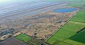
| West bank of the Lengen Sea from the observation tower on Zollweg in August 2003 | ||
| Geographical location | District of Leer , Lower Saxony | |
| Location close to the shore | Zetel , Westerstede , Uplengen | |
| Data | ||
| Coordinates | 53 ° 22 '0 " N , 7 ° 51' 24" E | |
|
||
| surface | 22 ha | |
| Maximum depth | 0.8 m | |
|
particularities |
Hochmoorsee |
|

|
||
| Overview map of the nature reserves around the Lengener Meer in the FFH area "Lengener Meer, Stapeler Moor, Baasenmeers-Moor" | ||

The Lengener Meer is a raised bog lake in the municipality of Uplengen in the district of Leer in East Friesland , Lower Saxony .
It is one of the few remaining raised bog lakes in Germany . The almost circular Flachsee, also called Moorauge or Kolk , is only 0.80 meters deep and covers 22 hectares . It is located in the middle of the former nature reserve (NSG) "Lengener Meer", a residual raised bog that has more or less degenerated through drainage, but is still growing in some cases . The former nature reserve has a size of 240 hectares and was part of the 1414 hectare FFH area "Lengener Meer, Stapeler Moor, Baasenmeers-Moor" . As of September 1, 2016, the newly designated nature reserve “ Stapeler Moor und Umgebung ” has risen.
location
The former “Lengener Meer” nature reserve and the former “ Stapeler Moor ” nature reserve ( Leer district ) form a coherent complex with the former “ Spolsener Moor ” nature reserve ( Friesland district ), which has been completely integrated into the “Stapeler Meer und Umgebung” nature reserve. This is located in northwestern Lower Saxony about twelve kilometers northwest of the city of Westerstede in the municipality of Uplengen. It belongs to the natural spatial unit of the "East Frisian Central High Moors " and with the now isolated, former Herrenmoor nature reserve and the Neudorfer Moor nature reserve to the northern part of the Lengener Moor sub-unit. The remains of the moor are in the apex of the "Oldenburg-East Frisian Geestrücken " on the watershed between the Jade Bay and the Ems . The series of raised bogs that formed here after the last ice age largely follows old meltwater channels . Its course can still be clearly seen in the area to the south and is at its widest in the Lengener Moor.
description
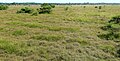
A few downy birches ( Betula pubescens ) and various grasses, especially the pipe grass ( Molinia caerulea ), form the vegetation of the water's edge. The moor still bears clear traces of the former moor fire culture . These can be seen in aerial photographs through the linear structures of former shallow trenches and former buckwheat fields . In the terrain, they can be recognized by the alternation of very wet and drier areas. The vegetation of the central areas is characterized by flat Bult-Schlenken complexes of the Oxycocco-Sphagnetea class (wet heather and raised bog societies) and raised bog degeneration stages in the form of pipe grass and gale shrub stands and is largely tree-free. Typical species are peat moss ( Sphagnum spp.), Rosemary heather ( Andromeda polifolia ) and sundew species ( Drosera rotundifolia, Drosera intermedia ), scabbard cottongrass ( Eriophorum vaginatum ), moor lily ( Narthecium ossifragum common ), white beaked reed ( Rhynchos common ) ( Trichophorum cespitosum ) and the common cranberry ( Vaccinium oxycoccos ). The edge zones are drier and are characterized by pipe grass and loose woody stands, comparable to the edge slopes of a natural raised bog. In the north-east and north-west of the plateau, a denser woody population of birch and pine has developed ( Betula pubescens, Pinus sylvestris ).
Hazard and protection
The former “Lengener Meer” nature reserve surrounding the Moorkolk was designated as early as 1940 in its core area of around 140 hectares. Subsequently, the connected NSG area north of the Zollweg was significantly expanded and further protected areas were designated in the Stapeler and Spolsener Moor. Despite being placed under protection, the many drainage ditches caused severe degeneration of the edge areas, which led to woody growth and the spread of pipe grass. In addition, most of the numerous smaller pools silted up in the area. Repeated sealing of the trenches has not yet been able to stop this trend, only the central part of the area has remained relatively natural. Since the spring of 2006, various fortification measures have been carried out in the area in order to stabilize the water balance in the area.
From the observation tower on Zollweg you can see the strong growth of wood to the north and west of the sea, to the east of the sea the more natural central area opens up a little further in the distance. Here the open expanse of the original natural landscape of the once around 70 km² large Stapeler-Moor-Complex can be seen.
Picture gallery
Aerial photo of the NSG from NE to SW in April 2006. In the background the Lengen Sea.
View from the high stand south of Kolk II to the southwest, August 2005.

Viewing platform on Zollweg

View from the viewing platform to the Lengen Sea, 2011

The open raised bog area in the middle of the area with a relatively natural Bult-Schlenken complex and some cripple pines typical of high bogs.


_-_01.jpg)


literature
- Thomas Huntke: Vegetation-ecological studies on the development of the Lengener Meer nature reserve (district of Leer) - a case study on the efficiency of nature conservation in raised bogs . - Dissertation, University of Oldenburg, 2008.
- K. Müller: Ecological and vegetation studies in East Frisian raised bogs . - Reports of the German Botanical Society 81: pp. 221–237, 1968.
- E. Pille: Today's potential natural vegetation and the real vegetation in the "Lengener Meer" nature reserve . In: Two East Frisian Inland Seas . - Works on the natural and regional studies of East Frisia, East Frisian Landscape, Aurich 1976.
- P. tom Diek: In the wide border moor . - Sunday supplement to Ammerländer 37, September 12, 1931.
- G. Wiegleb, W. Herr, D. Todeskino: Investigations into the need for protection and regenerability of the Neudorfer and Stapeler Moores (district of Leer, Reg.-Bez. Weser-Ems) . - Oldenburger Jahrbuch 1978/79: pp. 453–492, 1978.
See also
Web links
- Nature reserve "Lengener Meer" in the database of the Lower Saxony State Office for Water Management, Coastal and Nature Conservation (NLWKN)