List of architectural monuments in Dorsten
The list of architectural monuments in Dorsten contains the listed buildings in the area of the city of Dorsten in the Recklinghausen district in North Rhine-Westphalia (status: August 2009). These architectural monuments are entered in the list of monuments of the city of Dorsten; The basis for the admission is the Monument Protection Act North Rhine-Westphalia (DSchG NRW).
Architectural monuments are "monuments that consist of structures or parts of structures". The list of monuments of the city of Dorsten includes 99 monuments, including 35 residential buildings, 17 small monuments, 16 churches, chapels or monasteries, eleven courtyards or agricultural buildings, eight public buildings, four industrial or infrastructure structures, three aristocratic residences or fortifications, two residential and commercial buildings each and cemeteries as well as a commercial building. Of the total of 99 architectural monuments, 24 are in the old town , 15 in Holsterhausen , 14 in Hervest , eleven in Lembeck , nine in Rhade , seven in Wulfen , six in Feldmark , five each in Deuten and Hardt and three in Altendorf-Ulfkotte . There is no architectural monument in Östrich .
In addition, eleven ground monuments are listed in Part B and the miners' settlement from 1913 to 1929 in Hervest as a monument area in Part D of the list of monuments of the city of Dorsten. In addition, the Habiflex at Jägerstrasse 1-40 in Wulfen was proposed for the list of monuments.
Architectural monuments
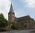
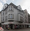
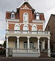
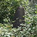
The list includes, if available, a photograph of the monument, the name if available, otherwise the type of building and the address or location in italics. The name corresponds to the name given by the city of Dorsten. Abbreviations have been resolved for better understanding, the typography has been adapted to that used in Wikipedia and typos have been corrected.
| image | designation | location | description | construction time | Registered since |
Monument number |
|---|---|---|---|---|---|---|

|
District Court | Old town Alter Postweg 36 map |
June 28, 1985 | 1 |
||
 more pictures |
catholic parish church | Old town Recklinghäuser Strasse 1 map |
St. Agatha | October 18, 1986 | 2 |
|

|
Residential building | Altstadt Alleestraße 30 map |
October 18, 1986 | 3 |
||
 more pictures |
Residential building | Old town An der Vehme 5 map |
Spiker house | October 18, 1986 | 4th |
|

|
Residential building | Holsterhausen Borkener Strasse 76 map |
October 18, 1986 | 5 |
||
 more pictures |
Stone cross | Old town Westwall / city wall map |
On the remains of the west wall | October 18, 1986 | 6th |
|

|
former watermill | Old town Gladbecker Strasse 88 map |
October 18, 1986 | 7th |
||
 more pictures |
former Boniface School | Holsterhausen Martin-Luther-Strasse 1 map |
Today's Maria Montessori School | October 18, 1986 | 8th |
|

|
Half-timbered house | Old town Kirchhellener Allee 60 map |
October 18, 1986 | 9 |
||
 more pictures |
former city scales | Old town market 1 card |
In the old town hall on the market square | October 18, 1986 | 10 |
|
 more pictures |
Remnants of the city wall | Altstadt Westgraben Südgraben map |
October 18, 1986 | 11 |
||

|
War memorial | Altendorf-Ulfkotte Altendorfer Strasse map |
October 18, 1986 | 12 |
||

|
Rogge farm | Hardt Bestener Strasse 70 map |
October 18, 1986 | 13 |
||

|
Vennemannhof | Hardt Bestener Strasse 65 map |
October 18, 1986 | 14th |
||
 more pictures |
Residential building | Hervest Dorfstrasse 4 map |
October 18, 1986 | 15th |
||
 more pictures |
Jägerhof restaurant | Hervest Dorfstrasse 3 map |
October 18, 1986 | 16 |
||
 more pictures |
Station chapel | Hervest Halterner Strasse 546 map |
at court May | October 18, 1986 | 17th |
|
 more pictures |
catholic parish church | Hervest Josefstrasse 1 map |
St. Joseph | October 18, 1986 | 18th |
|
 more pictures |
Station chapel | Hervest Kapellenweg / Orthöve map |
October 18, 1986 | 19th |
||
 more pictures |
Station chapel | Hervest Orthöve / Hof Kemna map |
October 18, 1986 | 20th |
||

|
Residential building | Hervest Paulusstrasse 9 map |
October 18, 1986 | 21st |
||

|
Schulte-Tendrich farm | Hervest Tenderichstrasse 1 map |
October 18, 1986 | 23 |
||

|
Station chapel | Holsterhausen Emmelkämper Weg / Am Steinwerk map |
October 18, 1986 | 24 |
||

|
Old Antonius Church (today the parish hall) | Holsterhausen Hauptstrasse 26 map |
1443 (extension to a church) | October 18, 1986 | 25th |
|

|
New Antoniuskirche (Catholic parish church) | Holsterhausen Hauptstrasse 34 map |
1912/13 | October 18, 1986 | 26th |
|

|
Hof Rasche | Holsterhausen Luisenstrasse 42 map |
October 18, 1986 | 27 |
||

|
Chapel of St. Anna | Holsterhausen Schermbecker Strasse / Emmelkämper Weg map |
October 18, 1986 | 28 |
||

|
Station chapel | Holsterhausen Stiller Weg / Hof Keller map |
October 18, 1986 | 29 |
||
|
Catholic Church | Lembeck Schulstrasse 1 map |
October 18, 1986 | 30th |
||

|
Wayside shrine (Pörtnerskrüz) | Lembeck Speckinger Weg map |
October 18, 1986 | 31 |
||

|
Wienbecker Mühlenhof | Suggest Weseler Straße 78- 82 (straight) Map |
October 18, 1986 | 32 |
||

|
Stone cross | Lembeck Speckinger Weg 91 map |
October 18, 1986 | 33 |
||
 more pictures |
catholic parish church | Rhade Urbanusring 12 card |
October 18, 1986 | 34 |
||

|
War memorial | Wulfen Hervester Strasse / Orthöver Weg map |
October 18, 1986 | 35 |
||

|
Residential building | Wulfen Burgring 24 card |
October 18, 1986 | 36 |
||
 more pictures |
catholic parish church | Wulfen Matthäusplatz 1 card |
October 18, 1986 | 37 |
||
 more pictures |
Residential building (former farmhouse) | Wulfen Matthäusplatz 5 card |
1854 | October 18, 1986 | 38 |
|

|
Rectory | Old town An der Vehme 1 map |
October 18, 1986 | 39 |
||
 more pictures |
Residential building | Old town Kappusstiege 19 card |
Seidemann's house | October 18, 1986 | 40 |
|

|
Ursuline Monastery | Altstadt Ursulastraße 8–12 (even) map |
October 18, 1986 | 41 |
||
|
Residential and commercial building | Altstadt Essener Strasse 24 map |
October 18, 1986 | 42 |
||
|
Residential building | Altstadt Alleestraße 9 map |
October 18, 1986 | 43 |
||

|
Residential building | Altstadt Alleestraße 7 map |
October 18, 1986 | 44 |
||

|
Residential building | Old town Gahlener Strasse 6 map |
October 18, 1986 | 45 |
||

|
Residential building | Old town Kirchhellener Allee 46 map |
October 18, 1986 | 46 |
||

|
Residential building | Old town Kirchhellener Allee 66 map |
October 18, 1986 | 47 |
||

|
Residential building | Altstadt Alter Postweg 12 map |
October 18, 1986 | 48 |
||

|
Residential building | Old town Alter Postweg 10 map |
October 18, 1986 | 49 |
||

|
Bell of the infirmary chapel | Hardt Birkenhahnweg / Haselhuhnweg map |
October 18, 1986 | 50 |
||

|
villa | Hardt Hafenstrasse 56 map |
October 18, 1986 | 51 |
||
 more pictures |
Residential building | Feldmark Marler Strasse 1 map |
October 18, 1986 | 52 |
||
 more pictures |
Residential building | Feldmark Bochumer Strasse 21 map |
October 18, 1986 | 53 |
||

|
villa | Feldmark Im Ovelgünne 14 card |
October 18, 1986 | 54 |
||

|
Residential and farm buildings | Holsterhausen Hauptstrasse 38 map |
October 18, 1986 | 55 |
||

|
Miners residence | Holsterhausen Koldenfeld 2, 4 Hauptstraße 1 map |
June 18, 1986 | 56 |
||

|
Apartment building | Holsterhausen Hauptstrasse 2 map |
October 18, 1986 | 57 |
||
 more pictures |
school-building | Hervest Bismarckstrasse 72 map |
Former Marienschule | October 18, 1986 | 58 |
|
 more pictures |
Half-timbered house (Pütter) | Hervest Hellweg 204 map |
Former post horse changing station, today there is a craft business | October 18, 1986 | 59 |
|

|
Residential building | Rhade Urbanusring 11 map |
October 18, 1986 | 60 |
||

|
Stable building | Rhade Debbingstrasse 10 map |
October 18, 1986 | 61 |
||

|
Residential house with stable building | Rhade Lembecker Strasse 38 map |
October 18, 1986 | 62 |
||

|
Wayside shrine (Pörtnerskrüz) | Wulfen Burgring 9 card |
October 18, 1986 | 63 |
||

|
Wayside shrine (Pörtnerskrüz) | Lembeck Rekener Strasse 2 map |
October 18, 1986 | 64 |
||

|
Stone cross | Holsterhausen Hauptstrasse / Pliesterbeckerstrasse map |
October 18, 1986 | 65 |
||

|
Stone cross | Wulfen Hervester Strasse / Im Wauert Map |
October 18, 1986 | 66 |
||

|
Crucifixion group | Hardt Philosopher's Path map |
October 18, 1986 | 67 |
||

|
Residential building | Altendorf-Ulfkotte Im Schlatt 43a map |
October 18, 1986 | 68 |
||

|
catholic parish church | Deut Kirchweg 11 map |
December 16, 1994 | 69 |
||
 more pictures |
catholic parish church | Hervest Dorfstrasse 2 map |
St. Paul | December 16, 1994 | 70 |
|

|
Courtyard | Hervest An der Wienbecke 171 map |
December 16, 1988 | 71 |
||
 more pictures |
Entrance building at Dorsten station | Old town On the Bovenhorst 21 map |
January 17, 1989 | 72 |
||

|
Water tower | Feldmark Am Wasserturm 20 card |
December 11, 1991 | 73 |
||

|
House and mill | Deuten Weseler Strasse 433 map |
Tüshaus mill | April 24, 1992 | 74 |
|
 more pictures |
Gas station system | Feldmark Bochumer Strasse 56 map |
old petrol station, then vacant for a long time, today there is “delicatessen currywurst” in cooperation with the Dorsten chef Björn Freitag | March 22, 1996 | 75 |
|

|
Residential, commercial, warehouse | Altstadt Alleestraße 15 map |
May 14, 1993 | 76 |
||

|
Rhader mill | Rhade Lembecker Strasse 140 map |
May 14, 1993 | 77 |
||

|
distillery | Deuten Weseler Strasse 433 map |
May 14, 1993 | 78 |
||

|
Kötterhaus | Altendorf-Ulfkotte Achterfeld 39a map |
19th century | December 29, 1993 | 79 |
|
|
milestone | Holsterhausen Freudenberg street map |
December 29, 1993 | 80 |
||

|
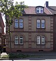
Midlicher mill | Lembeck Midlicher Bach 5 card |
December 29, 1993 | 81 |
||
|
Colliery house | Holsterhausen Hauptstrasse 5 map |
June 18, 1986 | 82 |
||
 more pictures |
Post office | Hervest Am Holzplatz 17 card |
Former post office, now Fatih Camii mosque | March 4, 1994 | 83 |
|
|
more pictures |
Lembeck Castle | Lembeck Wulfener Strasse map |
September 9, 1994 | 84 |
||

|
St. Michaelis Chapel | Lembeck Rhader Strasse 132 map |
1727 | December 16, 1994 | 85 |
|

|
Residential building | Rhade Debbingstrasse 13 map |
December 16, 1994 | 86 |
||

|
Half-timbered house | Rhade Urbanusring 10 card |
December 16, 1994 | 87 |
||
 more pictures |
House Hagenbeck | Holsterhausen Hagenbecker Strasse 111 map |
December 16, 1994 | 88 |
||
| historical road network | Altstadt old town center map |
December 16, 1994 | 89 |
|||

|
Jewish Cemetery | Feldmark Hasselbecke map |
December 16, 1994 | 90 |
||

|
abandoned cemetery | Altstadt Feldhausener Strasse map |
December 16, 1994 | 91 |
||

|
Two-column construction | Lembeck Endelner Weg / Im Zitter map |
December 22, 1995 | 92 |
||

|
Wayside shrine (Pörtnerskrüz) | Lembeck Michaelisweg 12 map |
December 22, 1995 | 93 |
||

|
Forester's house | Rhade Hakenweg 95 map |
October 24, 1997 | 94 |
||

|
Kötterhaus | Interpret Deutener Weg 9 map |
18th century | October 24, 1997 | 96 |
|

|
Cemetery portal | Rhade Höfer Weg map |
October 24, 1997 | 97 |
||

|
Wayside shrine (Pörtnerskrüz) | Lembeck Kaisersweg map |
October 24, 1997 | 98 |
||

|
double-sided wayside shrine | Lembeck Mergelkuhle 38 map |
October 24, 1997 | 99 |
||

|
Mine Fürst Leopold 1/2 | Hervest Halterner Strasse map |
Former colliery site, currently being converted into an industrial area. In the restored colliery buildings is the "Creativquartier Fürst Leopold" with gastronomy and art | May 25, 2004 | 100 |
|
 more pictures |
Wulfen station reception building | Wulfen Kleiner Ring 41 card |
August 24, 2007 | 101 |
||
|
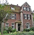
Residential building | Map Wulfen Weseler Straße 81 |
17th March 2014 | 102 |
literature
- Johannes Körner: District of Recklinghausen and urban districts of Recklinghausen, Bottrop, Buer, Gladbeck and Osterfeld . Sterndorf, Münster 1929, DNB 362509093 (The architectural and art monuments of Westphalia, Volume 39).
Web links
- Monument database of the Recklinghausen district
- Reason. (PDF; 3.5 MB) Part 1: General part. In: Land use plan of the city of Dorsten. Planning and Environment Office of the City of Dorsten, June 26, 2009, pp. 141–145 , accessed on October 3, 2011 .
Individual evidence
- ↑ § 2 (2) DSchG NRW
- ↑ a b List of monuments of the city of Dorsten
- ↑ Monument database of the Recklinghausen district ( Memento of the original from January 7, 2016 in the Internet Archive ) Info: The archive link has been inserted automatically and has not yet been checked. Please check the original and archive link according to the instructions and then remove this notice.
