
List of architectural monuments in Herrieden
The monuments of the Middle Franconian community of Herrieden are compiled on this page . This table is a partial list of the list of architectural monuments in Bavaria . The basis is the Bavarian Monument List , which was first drawn up on the basis of the Bavarian Monument Protection Act of October 1, 1973 and has since been managed by the Bavarian State Office for Monument Preservation . The following information does not replace the legally binding information from the monument protection authority. This list reflects the update status from November 21, 2014 and contains 177 architectural monuments.

Ensembles
Ensemble old town Herrieden
The ensemble ( location ) encompasses the entire city enclosed by the city fortifications, including the former city moats and the Altmühlbrücke. The ensemble is visually related to the Martinskirche (cf. Am Martinsberg 22) and is characterized by the grouping of a church on a hill with a fortified town center on the river, which is characteristic of Franconian city foundations. The beginnings of the city of Herrieden lie in a former Benedictine monastery on the one hand and the Martinskirche on the other. The Benedictine monastery, which was founded in the last quarter of the 8th century by the Franconian nobleman Cadolt and mentioned for the first time in 797, was donated by King Arnulf to Bishop Erchanbold von Eichstätt in 888 and converted into a collegiate monastery. It remained in the possession of Eichstätt until secularization; In 1807 a parish was established there. Today's Catholic side church St. Martin can be opened as a parish church for the time before 780 and remained so until the secularization. Its effective location on a fortified hill northeast of the city, within a walled cemetery, is at the same time an expression of the historical context; a Stationsweg (stone path) also connects the church and town. Another historical and urban focal point of the place, first mentioned as a city in 1298, is the castle, mentioned in 1122, in the northeast corner of the complex. This brewery, which was rebuilt many times until the 19th century, was also re-fortified and incorporated into the city when the city wall was rebuilt under the Archbishop of Eichstätt Heinrich V. 1340/44 . The city's interior, which is sometimes quite extensive, is divided into four structurally clearly differentiated quarters that surround the wide market square. This, dominated by the two-tower front of the collegiate church, essentially a building from the first half of the 16th century, is surrounded by the eaves-side Gasthaus zum Hirschen (Marktplatz 13) and stately gabled houses on the west side of the Frauenkirche. The former quarter of the monastery and collegiate church (Herrnhof), around the two churches, is loosely built up, with partly detached former collegiate courts and administrative buildings from the 16th to 19th centuries. The bourgeois quarter of the craftsmen and traders on both sides of the former Vorderen Gasse (today the Ringstrasse) has some stately, two-story, gable-roof houses from the 16th to the 18th century that face the street. To the north is an arable district with smaller single-storey houses accompanied by farm buildings. In the area of the Vogteiplatz in front of the former castle, there is a district mainly characterized by barns. The market-like square in front of the former Ansbacher Tor, dominated by the Gasthaus zum Torwirt (Neunstetter Str. 14), is part of the ensemble. In the south and south-west, in the area of the Altmühl river valley, the original open space in front of the city wall has been preserved. In the east, via the undeveloped parcel No. 1050, there is also an unobstructed view of the city. File number: E-5-71-166-1.
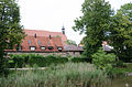
Ensemble town center Roth
The rounded green, in the center of which is the local chapel of St. Barbara from 1702, surrounded by four linden trees, is delimited by the gable ends of the farmhouses oriented towards the green. These single-storey residential buildings with partially diverse gable roof outbuildings go back essentially to the 17th century, but were mainly developed in the 19th century. File number: E-5-71-166-2.
City fortifications
The city wall made of stone and quarry stone masonry is almost completely preserved, without its original cover. It was rebuilt in 1340/44 and reinforced again in the late 15th century. The area of the Zwinger and Graben is recognizable throughout and has been preserved in some places. File number: D-5-71-166-1. Pictures . Counter- clockwise starting at the Storchenturm , the city wall runs along Deocarplatz and the Herrenhof with a breakthrough between Herrenhof 13 and 12, then north to the former castle and from there to the breakthrough at the Fronveste . To the west of the Fronveste, the city wall along the street An der Stadtmauer has been preserved until the breakthrough at Neunstetter Straße. The southwest section runs along Vorderen Gasse and Turmstrasse to the Storchenturm.

Stork tower, field side

City wall Marktplatz 5

City wall and moat Deocarplatz 9, 7, 5
City wall and moat Deocarplatz 9, 7, 5

City wall Herrnhof 14

Herrnhof city wall 13
City wall Herrnhof 12

City wall at the castle, field side

City wall Vogteiplatz 6
Fronveste

City wall At the city wall 5

City wall At the city wall 5

City wall Vordere Gasse 25


| location | object | description | File no. | image |
|---|---|---|---|---|
| Deocarplatz 3 ( location ) |
City fortifications | Belonging | D-5-71-166-9 | |
| Fronveststrasse 12 ( location ) |
Former city tower with prison, later residential building | Four-storey hipped roof building with a semicircular end, partly 15th century; associated city fortifications | D-5-71-166-13 |
 more pictures |
| Herrnhof 9 ( location ) |
City fortifications | Belonging | D-5-71-166-20 | |
| Herrnhof 10 ( location ) |
City fortifications | Belonging | D-5-71-166-21 | |
| Marktplatz 6 ( location ) |
Gate tower, so-called stork tower | Humped ashlar masonry with a hipped roof and an ogival passage, around 1340 | D-5-71-166-29 |
 more pictures |
| Vogteiplatz 8; Vogteiplatz 10; Near Münchener Strasse ( location ) |
City fortifications | Belonging | D-5-71-166-57 | |
| Vordere Gasse 19 ( location ) |
City fortifications | Belonging | D-5-71-166-48 | |
| Vordere Gasse 21 ( location ) |
City fortifications | Belonging | D-5-71-166-49 |
Architectural monuments according to districts
Herrieden
| location | object | description | File no. | image |
|---|---|---|---|---|
| Altmühl ( location ) |
Bridge over the Altmühl | Three-arched stone bridge, 18th century, inscribed "1770", with two Nepomuk figures, 19th / 20th century. century | D-5-71-166-61 |
 more pictures |
| At Martinsberg 22; Steinweg; Near Steinweg; At Martinsberg 22; At Martinsberg 40; Ball fault field; Steinweg; Steinweg 8 ( location ) |
Catholic minor church St. Martin | Hall church, new building inaugurated in 1688 after the fire of the previous building, extensive renovations by Gabriel de Gabrieli in 1721, tower in 1732/33; with equipment
Cemetery, first half of the 18th century 30 epitaphs from canons and monastery officials, 16th to 18th centuries 4 figures of a popular Mount of Olives group, probably late 17th century, in an open hall Tombs, especially 19th and 20th centuries; 19th century cast iron crucifix Walling, first half of the 18th century 7 station shrines in housings, 18th century, on the footpath from the city to St. Martin |
D-5-71-166-2 |
 more pictures |
| At the city wall 3 ( location ) |
Residential building | Narrow eaves building with mansard roof, partly timber-framed, 18th / 19th century Century; partly sitting on the city wall | D-5-71-166-3 |
 more pictures |
| At the city wall 14 ( location ) |
Residential building, so-called Jungfernhäusl | Two-storey hipped roof building, partly half-timbered, 18th century | D-5-71-166-188 |
 more pictures |
| Ansbacher Straße 2 ( location ) |
Residential building | Two-storey gable-independent gable roof building, plastered half-timbering, in the core 17th / 18th century. century | D-5-71-166-5 | |
| Ansbacher Straße 4 ( location ) |
Residential buildings | Two-storey, gable-independent saddle roof construction, mainly half-timbered, in the core 17th / 18th. century | D-5-71-166-6 | |
| Brühlwiesen, 500 m outside on the road towards Mühlbruck ( location ) |
Wayside cross, wayside shrine | Cast iron on a sandstone base, late 19th century | D-5-71-166-66 | |
| Deocarplatz 1 ( me ) |
Former primary school building, now a special school | Two-storey three-wing building with a high base, hipped and half-hipped roof, with a dwelling, rusticated pilaster strips and plastered structure, in neo-baroque forms of the Munich school, 1914/16 | D-5-71-166-8 |
 more pictures |
| Deocarplatz 2; Deocarplatz 3 ( location ) |
Former canon house | Two-storey building with half-hipped roof, baroque facade structure with central projection, gate pillars, second half of the 18th century; Expanded in 2000 as an extension of the Wolfhard School (see Deocarplatz 1)
With gate pillars, probably 19th century |
D-5-71-166-9 |
 more pictures |
| Deocarplatz 10 ( location ) |
Former tithe barn | Two-storey eaves gable roof construction, massive, quarry stone and sandstone masonry, in the core around 1800 using older structural parts | D-5-71-166-193 | |
| Fronveststrasse 2 ( location ) |
Residential buildings | Two-storey saddle roof building in corner position, core 16th century, with house Madonna, wood framed, around 1500 | D-5-71-166-11 |
 more pictures |
| Fronveststrasse 3 ( location ) |
Gabled house | Single storey, plastered half-timbering, 17th to 19th centuries
Outbuildings, partly half-timbered, at the same time |
D-5-71-166-12 | |
| Herrnhof 1 ( location ) |
Catholic minor church of Our Lady | Flat-roofed hall building with reticulated late Gothic choir, new building, 1474 and after fire in 1493, roof turret 1703, change 17th / 18th. Century and 19th century; with equipment | D-5-71-166-15 |
 more pictures |
| Herrnhof 2 ( location ) |
Former old provost house | Two-storey building with a crooked roof, corner position, half-timbered, cantilevered upper floor, 1490 ( dendrochronologically dated), second half of the 17th century | D-5-71-166-16 |
 more pictures |
| Herrnhof 3 ( location ) |
Inn | Two-storey saddle roof construction, half-hip on one side, plastered half-timbering, partially cantilevered upper floor, 18th / 19th century Century, in the core before 1600
With outbuildings, massive, gable and hipped roof, partly half-timbered, 18th / 19th century. century Parts of the enclosure that have been preserved, 19th century |
D-5-71-166-17 |
 more pictures |
| Herrnhof 4; Herrnhof 5 ( location ) |
Former stable house | Free-standing, two-storey saddle roof construction, plastered half-timbering, in the core before 1500 | D-5-71-166-18 |
 more pictures |
| Herrnhof 9 ( location ) |
Former prison | Two-storey hipped roof structure, structured in natural stone, rusticated corner pilaster strips, around 1900 | D-5-71-166-20 |
 more pictures |
| Herrnhof 10 ( location ) |
Former district court building, town hall | Two-storey hipped roof building, with natural stone structures, central projection with gable top, neo-baroque, around 1900 | D-5-71-166-21 |
 more pictures |
| Herrnhof 20, 21, 22; Deocarplatz; Herrnhof ( location ) |
Former collegiate dean, today the rectory | Two-story hipped roof building with a dwelling, rusticated pilaster strips and plaster structure, wooden figures, second half of the 18th century; with equipment
Southern part of the enclosure, 18./19. century |
D-5-71-166-23 |
 more pictures |
| Marketplace 1 ( location ) |
Former collegiate church, now the Catholic parish church of St. Veit | Relay hall, three-aisled nave with double tower facade, three-bay choir, Blasius chapel, sacristy, Nicholas chapel, Peter and Paul chapel, lower storeys of the towers probably around 1300, choir built in 1447 by Edress Embhart the Elder in 1340. Ä. replaced, 1502–1522 new building of the nave, arching of the nave in 1740, Baroque modification around 1748, changes in the 19th century, with ridge turrets; with equipment | D-5-71-166-24 |
 more pictures |
| Marketplace 2 ( location ) |
Former caste office and former schoolhouse | Two-storey building with a pitched roof, partially preserved, reconstruction from "1523" (inscribed), changed in the 19th century | D-5-71-166-25 |
 more pictures |
| Marketplace 3 ( location ) |
Former town hall, also a bread house | Two-storey building with a pitched roof, plastered structure, 1548, with changes from the 18th / 19th centuries. Century, marked "1752" | D-5-71-166-26 |
 more pictures |
| Marketplace 4 ( location ) |
Inn | Two-storey saddle roof construction in corner position, with rusticated corner pilasters, plaster structure, core around 1600 | D-5-71-166-27 |
 more pictures |
| Marktplatz 8 ( location ) |
Residential and commercial building | Two-storey gable roof building, with a half-hip at the back, plastered half-timbering, probably 18th century, with an older core | D-5-71-166-30 |
 more pictures |
| Marketplace 10 ( location ) |
Town house, later residential and commercial building | Two-storey building with a pitched roof, half-hipped at the back, in corner position, half-timbered plastered, the core around 1600 | D-5-71-166-31 |
 more pictures |
| Marktplatz 11, 12 ( location ) |
Residential buildings | Two-storey building with a mansard hipped roof, in a corner position, solid, around 1800
Barn, two-story, with a mansard roof, half-timbered upper floor, probably 17th century |
D-5-71-166-32 |
 more pictures |
| Marktplatz 18 ( location ) |
Allegedly the former town hall | Two-storey building with a mansard hipped roof, late 18th century, attached to the western front of the Frauenkirche
Associated free-standing barn, single-storey building with pitched roof, half-timbered gable, 18th century |
D-5-71-166-35 |
 more pictures |
| Near Hintere Gasse ( location ) |
barn | Single-storey building with a pitched roof, half-timbered, 17th century | D-5-71-166-45 | |
| Near Münchener Strasse; north of the Fronveste on Münchener Strasse ( location ) |
Trinity Chapel | Massive small saddle roof building with ornamental gable, rear with hip, 18th century | D-5-71-166-64 |

|
| Near Münchener Strasse; north of the Fronveste on Münchener Strasse ( location ) |
Stone cross | Medieval | D-5-71-166-65 |

|
| Near Neunstetterstraße, on the outskirts ( location ) |
crossroads | Cast iron, mid 19th century | D-5-71-166-42 | |
| Near Vogteiplatz ( location ) |
barn | One-storey building with a pitched roof, with a half-timbered gable, with a beveled corner, second half of the 16th century | D-5-71-166-54 | |
| Neunstetterstraße 1 ( location ) |
Residential buildings | Narrow two-storey saddle roof building, in corner position, half-timbering plastered, in the core 16./17. Century, bordering the city wall at the back, see city fortifications | D-5-71-166-36 |
 more pictures |
| Neunstetterstrasse 11; Neunstetterstraße 13 ( location ) |
Former shepherd's house | Single-storey semi-detached house with mansard hipped roof, around 1800 | D-5-71-166-38 |
 more pictures |
| Neunstetterstraße 12 ( location ) |
Residential buildings | Two-storey gable roof building, half-timbered, 17th century | D-5-71-166-39 |
 more pictures |
| Neunstetterstraße 14 ( location ) |
Inn | Two-storey saddle roof building, in corner position, with half-timbered gable, 17th / 18th centuries century | D-5-71-166-40 |
 more pictures |
| Neunstetterstrasse 15; Neunstetterstraße 17 ( location ) |
Former shepherd's house | Semi-detached house, one-story building with a mansard hipped roof, around 1800 | D-5-71-166-41 |
 more pictures |
| Gunwases; State road 2248, on the state road to Leibelbach, 20 m after the bridge ( location ) |
crossroads | Gilded cast iron, sandstone base, second half of the 19th century | D-5-71-166-67 | |
| Siechwiesen, about 300 m west of the infirmary chapel in the Flur an der Altmühl ( location ) |
Chapel shrine | Small massive building with a gable roof, with a picture niche, 18th century | D-5-71-166-63 | |
| Siechwiesen ( location ) |
Catholic Infirmary Chapel of Mary Help | Brick building, with natural stone integration, neo-Gothic, 1886/87; with equipment | D-5-71-166-62 | |
| Turmstrasse 1 ( location ) |
Residential buildings | Two-storey, gable-independent building with a mansard roof, half-hipped at the rear, with ornamental gable, plastered structure, around 1700 | D-5-71-166-53 |
 more pictures |
| Vogteiplatz 7 ( location ) |
Barn, part of the former brewery | Single-storey saddle roof building with half-timbered gable, first half of the 18th century | D-5-71-166-56 |
 more pictures |
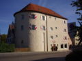
| Vogteiplatz 8, 10; Near Münchener Strasse ( location ) |
Former castle | Built before 1122, rebuilt after razing in 1316 in 1340/44, burned down in 1490 and rebuilt in 1508-10, structural changes in 1686 and 1717 | D-5-71-166-57 |
 more pictures |
| Vogteiplatz 8, 10; Near Münchener Strasse ( location ) |
Former castle, residential building | Three-storey saddle roof building, rebuilt after a fire in 1877–1878 | D-5-71-166-57 |
 more pictures |
| Vogteiplatz 8, 10; Near Münchener Strasse ( location ) |
Former castle, brewery building | 1717 | D-5-71-166-57 |
 more pictures |
| Vogteiplatz 8, 10; Near Münchener Strasse ( location ) |
Former castle, former gate building | Rectangular stone building with a mansard hipped roof, heraldic panel inscribed "1510" | D-5-71-166-57 |
 more pictures |
| Vogteiplatz 8, 10; Near Münchener Strasse ( location ) |
Former castle, pavilion | Eight-sided stone building with a mansard tent roof, around 1800
Garden shed, one-storey rectangular building with a gable roof, around 1800 |
D-5-71-166-57 |
 more pictures |
| Vogteiplatz 8, 10; Near Münchener Strasse ( location ) |
Former castle, stone bridge | Rebuilt after 1490 | D-5-71-166-57 | |
| Vogteiplatz 8, 10; Near Münchener Strasse ( location ) |
Former castle, fortification walls | Renewed in 1412 and 1508–1510, the core probably older | D-5-71-166-57 | |
| Vogteiplatz 11 ( location ) |
Former tax office | Three-storey building with a pitched roof, with plaster structure, 17th century, changes in the first third of the 18th century by Gabriel de Gabrieli and in the 19th century | D-5-71-166-58 |
 more pictures |
| Vordere Gasse 1 ( location ) |
Residential building | Two-storey hipped roof building, partly half-timbered, dwarf house, 17th / 18th Century, change around 1910 | D-5-71-166-43 |
 more pictures |
| Vordere Gasse 13 ( location ) |
Residential building | Two-storey building with a pitched roof, hip to the rear, in a corner position, plastered half-timbering, 18th century | D-5-71-166-46 |
 more pictures |
| Vordere Gasse 19 ( location ) |
Gabled house | Recessed, plastered half-timbering, 18th century | D-5-71-166-48 |
 more pictures |
| Vordere Gasse 21 ( location ) |
Residential building | Two-storey saddle roof building in corner position, tail gable with figure attachments, core at the beginning of the 15th century, rebuilt and renewed around 1630 and beginning of the 18th century | D-5-71-166-49 |
 more pictures |
| Front Lane 33; Vordere Gasse 35 ( location ) |
Gabled house with volute gable | 18th century, altered in 1910 | D-5-71-166-51 |
 more pictures |
| Wolfhardstrasse 5 ( location ) |
Residential buildings | Two-storey gable-independent gable roof building, upper floor and gable half-timbered, with projecting gable, 18th / 19th century century | D-5-71-166-59 |
 more pictures |
| Wolfhardstrasse 7 ( location ) |
Residential buildings | Narrow two-storey saddle roof construction, in parts half-timbered, in the core 17th / 18th century. century | D-5-71-166-60 |
 more pictures |
Heat
| location | object | description | File no. | image |
|---|---|---|---|---|
| Oberbichl; at the exit to Herrieden ( location ) |
crossroads | Second half of the 19th century, flanked by two linden trees | D-5-71-166-68 |

|
| From Heuberg to the district road AN 37, at the end of town on the road to Heuberg ( location ) |
Catholic Lady Chapel | Small massive gable roof building, with plaster structure, 1727 | D-5-71-166-69 |

|
Elbersroth
| location | object | description | File no. | image |
|---|---|---|---|---|
| At the Wieseth; on the road to Leukersdorf ( location ) |
crossroads | Cast iron on a sandstone base, second third of the 19th century | D-5-71-166-79 | |
| Near Pfarrer-Heumann-Straße ( location ) |
War memorial | Gotizing in wayside shrine, 1914/18 | D-5-71-166-75 | |
| Near Pfarrer-Heumann-Straße ( location ) |
graveyard | Plant around 1910
Cemetery house, small single-storey building with hipped roof, probably at the same time With numerous matching grave monuments from the same period, mostly in the form of steles, Jechnerer tombstone, late 18th century Enclosure, around 1910, with vase-shaped gate pillar crowns, late 18th century |
D-5-71-166-74 | |
| Near Wiesethstraße, on the road to Sickersdorf ( location ) |
Wayside chapel | Small, massive gable roof building, neo-Gothic, with Madonna figure, around 1850 | D-5-71-166-77 | |
| Pfarrer-Heumann-Strasse, north of the church at the bridge ( location ) |
Wayside shrine | Solid, with a gable roof, with a brick niche, 18th / 19th century century | D-5-71-166-76 | |
| Pfarrer-Heumann-Straße 1 ( location ) |
Rectory, residential building | Two-storey hipped roof building, early 18th century, later extended
Property wall, probably 18th century |
D-5-71-166-73 | |
| Pfarrer-Heumann-Straße 5 ( location ) |
Catholic Parish Church of St. James the Elder | Hall church, new building by Carl Jäger , 1925, with neo-baroque elements, former choir from around 1750 included as a chapel, tower with onion dome; with equipment | D-5-71-166-70 |
 more pictures |
| Pfarrer-Heumann-Straße 6 ( location ) |
Massive farmhouse | Dormitory extension, 1851
oven |
D-5-71-166-72 | |
| Pfarrer-Heumann-Straße 13 ( location ) |
Former granulator | Single-storey massive saddle roof construction, marked "1809"
Outbuildings, barn, two-storey pitched roof buildings, partly half-timbered, probably early 19th century |
D-5-71-166-71 | |
| On the old Herrieder Weg in the forest, 300 m outside ( ) |
crossroads | Wooden crucifix, gilded, 19th century; not re-qualified, not mapped in the Bavarian Monument Atlas | D-5-71-166-80 | |
| Weinberger Straße 7, at the junction to Weinberg ( location ) |
Wegkapelle Herz Jesu | Small massive gable roof building, 1909 | D-5-71-166-78 |
Gimpertshausen
| location | object | description | File no. | image |
|---|---|---|---|---|
| Early measuring wood, west at the edge of the forest ( location ) |
Field chapel | Small solid building with a gable roof, with a cast iron crucifix, second half of the 19th century | D-5-71-166-82 | |
| Gimpertshausen 2 ( location ) |
Residential stable house | Single-storey building with a pitched roof, 1777, partly older core | D-5-71-166-81 | |
| Mill field; From Leuckersdorf to Gimpertshausen ( location ) |
crossroads | Crucifix with figure of Mary, cast iron on red sandstone base, second third of the 19th century | D-5-71-166-83 |
Heuberg
| location | object | description | File no. | image |
|---|---|---|---|---|
| Heuberg 13 ( location ) |
Residential stable house | Single-storey gable roof construction, massive, 1858 | D-5-71-166-85 | |
| In Heuberg ( location ) |
Holy Trinity Catholic Chapel | Single-storey saddle roof structure, one side with hip, with tail gable, roof turret, around 1700; with equipment | D-5-71-166-84 | |
| Strutfeld, about 150 m northeast in the corridor ( location ) |
Field cross | Cast iron on stone base, 19th century | D-5-71-166-86 |
Hohenberg
| location | object | description | File no. | image |
|---|---|---|---|---|
| At the exit to Herrieden ( location ) |
crossroads | Crucifix on a sandstone base, with memorial inscription for members of the founder, First and Second World War | D-5-71-166-87 | |
| At the exit to Herrieden ( location ) |
Fraischstein | Sandstone, with a Hohenzollern eagle or crook, 1555 | D-5-71-166-88 |
Lammelbach
| location | object | description | File no. | image |
|---|---|---|---|---|
| Gründlesfeld, at the exit to Leibelbach ( location ) |
War memorial | Wayside cross, cast iron on sandstone base, probably second quarter of the 20th century | D-5-71-166-91 |

|
| Hartfeld; From district road AN 54 (Lammelbach) to state road 2248, 200 m outside the village on the road to Leibelbach ( location ) |
crossroads | Cast iron crucifix on sandstone base, second half of the 19th century, with inscription | D-5-71-166-92 |

|
| In Lammelbach, at the exit to Leibelbach ( location ) |
Former flax breaker house | Single-storey saddle roof structure, converted into a fire station in the early 20th century | D-5-71-166-90 | |
| Lammelbach 5 ( location ) |
Farmhouse | Two-storey saddle roof structure, with plaster structure, verge tiles with ornamental decor and mask, around 1912 | D-5-71-166-89 |
Slatted book
| location | object | description | File no. | image |
|---|---|---|---|---|
| Berglesfeld, on the road to Oberschönbronn ( location ) |
Votive cross, wayside cross | Cast iron crucifix on a sandstone plinth, with an inscription for a happy homecoming from the First World War, probably second quarter of the 20th century | D-5-71-166-98 | |
| In Lattenbuch ( location ) |
Single-storey day laborer's house | Partly plastered half-timbering, late 18th century | D-5-71-166-96 | |
| In Lattenbuch, on Dorfstrasse ( location ) |
crossroads | Cast iron, mid 19th century | D-5-71-166-97 | |
| In Lattenbuch ( location ) |
Catholic branch church Mater dolorosa | Hall church, west tower with onion dome, built in 1935; with equipment | D-5-71-166-93 | |
| Lattenbuch 4 ( location ) |
Residential stable house | Two-storey eaves gable roof building, 1909, inscription plaque with crucifixion, 18th century, used again in 1909
Barn, single-storey saddle roof construction, probably at the same time |
D-5-71-166-94 | |
| Lattenbuch 19 ( location ) |
Residential stable house | Solid, second half of the 18th century | D-5-71-166-95 | |
| Lattenbuch 33, at the exit to Schönau ( location ) |
crossroads | Cast iron crucifix, mid 19th century | D-5-71-166-100 | |
| Lindlein, on the road to Schönau, 300 m outside ( location ) |
crossroads | Cast iron crucifix, mid 19th century | D-5-71-166-99 | |
| From Lattenbuch to the district road AN 37, one and a half kilometers outside on the road to Schönau ( location ) |
Memorial stone in the form of a wayside shrine | Inscribed "1928" | D-5-71-166-101 |

|
Leibelbach
| location | object | description | File no. | image |
|---|---|---|---|---|
| In Leibelbach, at the exit towards Lammelbach ( location ) |
War memorial | Cast iron cross on a sandstone base, inscribed "1914/18", changed after 1945 | D-5-71-166-103 | |
| Leibelbach 3 ( location ) |
Wayside shrine | On the gable side of the building, with wooden figures, Holy Trinity, Maria Immaculata, by Johann Mutschelle the Elder. J., inscribed "1731" | D-5-71-166-102 | |
| Sand field, 100 m outside on the road to Limbach ( location ) |
crossroads | Cast iron crucifix on a sandstone base, mid-19th century | D-5-71-166-104 |
People book
| location | object | description | File no. | image |
|---|---|---|---|---|
| People book 8 ( location ) |
Heart-shaped brick with cross and anchor in the east gable | Early 19th century | D-5-71-166-105 | |
| People Book 10 ( location ) |
Reliefs from the former Rauenzell pilgrimage church | Second half of the 16th century; in the southern gable wall and western long side | D-5-71-166-106 |
Limbach
| location | object | description | File no. | image |
|---|---|---|---|---|
| Limbacher Gigert, 200 m outside the village, north in the corridor at the edge of the forest ( location ) |
Field cross | Cast iron crucifix, second third of the 19th century, on a sandstone base, inscribed "1907" | D-5-71-166-107 |
Mühlbruck
| location | object | description | File no. | image |
|---|---|---|---|---|
| ( Location ) | Wayside shrine | 1702; built over with the chapel; not re-qualified | D-5-71-166-110 | |
| In Mühlbruck, at the exit to Herrieden ( location ) |
Catholic chapel | Small, massive gable roof building, with hip at the back, with tail gable, 18th century
Wayside shrine, 1702, built over with the chapel |
D-5-71-166-109 | |
| Mühlbruck 2 ( location ) |
Discharge house | Single-storey, massive gable roof building, late 18th century
Barn, massive gable roof, 1849 |
D-5-71-166-108 |
Neunstetten
| location | object | description | File no. | image |
|---|---|---|---|---|
| Altmühl ( location ) |
Altmühlbrücke | Three-arched stone bridge, 1833, with a Nepomuk figure from the same period | D-5-71-166-119 |

|
| At the Altmühl 1 ( location ) |
Altmühle, mill and residential buildings | Two-storey, massive saddle roof construction, with corner pilasters, 1848 | D-5-71-166-113 | |
| At the Altmühl 1 ( location ) |
Old mill, barn | Single-storey saddle roof construction with loading hatch, second half of the 19th century | D-5-71-166-113 | |
| Eulersfeld; Steinbacher Feld, east outside in the corridor ( location ) |
Field cross, wayside shrine | Sandstone with a cast-iron cross attachment, probably 19th century | D-5-71-166-124 | |
| Hertwegfeld, on the outskirts in the direction of Herrieden ( location ) |
Group of six stone crosses, called the "Seven Carters" | Medieval | D-5-71-166-123 | |
| Hertwegfeld, one kilometer outside in the direction of Mühlbruck ( location ) |
crossroads | Crucifix, wood, folk carving, 19th century | D-5-71-166-125 | |
| Hilsbacher Weg, Lichtfeld ( location ) |
Wayside shrine | Sandstone pillar with cross top, allegedly around 1680, parts renewed | D-5-71-166-196 |

|
| Kirchplatz 1 ( location ) |
Catholic parish church of St. Vitus | Hall church, single nave and west choir, late 14th century, east choir added before 1438, tower in 1482, expanded in 1680/81, changes in 17th and 18th centuries. and 19th century; with equipment
Cemetery, formerly fortified, partially preserved moat, underground Karner vault, tombs 19./20. century Cast iron crucifix, mid 19th century Walling with defensive wall at chest height, in the core probably 15th century |
D-5-71-166-111 |
 more pictures |
| Mühlstrasse 5 ( location ) |
Former mill | Solid two-storey house with a gable roof, 1838 | D-5-71-166-115 | |
| Near the main road, on the outskirts in the direction of Herrieden ( location ) |
Neo-Gothic wayside shrine | Cast iron cross on a sandstone base, 1892 | D-5-71-166-122 | |
| Near the church square, at the cemetery ( location ) |
War memorial | Stele with crowning figure of Saint George, 1914/18, changed after 1945 | D-5-71-166-120 | |
| Near Mühlstrasse ( location ) |
barn | Single-storey building with half-hipped roof, half-timbered, 19th century | D-5-71-166-116 | |
| Close to Windmühlstraße, on the western outskirts in Anger south of the street ( location ) |
Wayside shrine | Small brick aedicula with niche, around 1800 | D-5-71-166-121 | |
| Pfarrgasse 2 ( location ) |
Residential building | Two-storey saddle roof building, with half-timbered upper storey and gable, partly above the southwest corner of the cemetery wall, probably 17th century | D-5-71-166-117 | |
| From state road 2249 to Oberdombach, on Leutershauser Straße between Neunstetten and Niederdombach, at the junction to Oberdombach ( location ) |
Statue on a rectangular base | Inscribed "1723" with a cast iron cross | D-5-71-166-192 |

|
| Windmühlstraße 1, at the exit to Ansbach ( location ) |
crossroads | Wooden crucifix, mid-19th century | D-5-71-166-126 |
Niederdombach
| location | object | description | File no. | image |
|---|---|---|---|---|
| At the forest, 1100 m outside on the way to Höllmühle ( location ) |
Wayside shrine with trinity relief | 1730 | D-5-71-166-128 | |
| Grobwiesen, 100 m outside in the direction of Neunstetten ( location ) |
crossroads | Cast iron, second third of the 19th century | D-5-71-166-129 | |
| In Niederdombach, in the center of the village near the Höllmühlbach ( location ) |
chapel | Catholic St. Antonius Chapel, small massive saddle roof building with ornamental gable, plaster structure, inscribed "1736", with ridge turret; with equipment | D-5-71-166-127 |

|
| State road 2249, 100 m outside in the direction of Leutershausen ( location ) |
crossroads | Crucifix on a stone base, first half of the 20th century | D-5-71-166-130 |
Oberschönbronn
| location | object | description | File no. | image |
|---|---|---|---|---|
| Oberschönbronn 8 ( location ) |
Residential stable house | Two-storey saddle roof building, massive, with plaster structure, mid-19th century | D-5-71-166-131 | |
| Oberschönbronn 18 ( location ) |
barn | Two-storey saddle roof building, upper storey and gable half-timbered, early 18th century | D-5-71-166-132 |
Rauenzell
| location | object | description | File no. | image |
|---|---|---|---|---|
| On the Judenweg; Veldener Straße, at the exit towards Velden ( location ) |
Wayside shrine | Historicizing, 1923 | D-5-71-166-144 | |
| At shelter 32 ( location ) |
Boom with pub sign | Probably later 18th century | D-5-71-166-138 | |
| Ground meadows; State road 2249, 500 m outside on the road to Herrieden ( location ) |
crossroads | Cast iron crucifix with a figure of Mary on a sandstone base, around 1880/90 | D-5-71-166-145 | |
| Breitfeld, on the footpath to Herrieden, about 900 m west of the village ( location ) |
Wayside shrine | Eight-sided pillar with a four-gabled top, late medieval, next to it a free-standing stone altar, probably at the same time | D-5-71-166-143 | |
| Eisenfeld, 1.4 km before leaving the village in the direction of Rös ( location ) |
crossroads | Cast iron crucifix on a sandstone base, second half of the 19th century | D-5-71-166-147 | |
| Fuchsloch, two kilometers before leaving the village in the direction of Rös ( location ) |
crossroads | Cast iron crucifix on sandstone base, late 19th century | D-5-71-166-146 | |
| On the southern outskirts at Veldener Straße 6 ( location ) |
Wayside chapel | Small massive gable roof building, natural stone cuboid, with a figure of the Mother of God, inscribed "1848" | D-5-71-166-191 | |
| Röser Straße 2 ( location ) |
Relief of Saint Anna Selbdritt | Walled in in the gable, second half of the 16th century; from the abandoned pilgrimage church | D-5-71-166-139 | |
| Steinbach-Trüdinger Forst, in the Steinbachwald, about 1000 m southeast of the parish church ( location ) |
Wayside shrine | Late medieval, protruding gable housing and arched niches | D-5-71-166-142 | |
| Steinbach-Trüdinger Forst, in the Steinbachwald, about 500 m southeast of the parish church ( location ) |
Wayside shrine | Solid, protruding gable housing with gable roof and round arch niches, probably from the late Middle Ages | D-5-71-166-141 | |
| Zum Steinbachwald 4, on the main road north of the bridge ( location ) |
Wayside shrine | Stone pillar with a sheet metal cross, 18th century | D-5-71-166-140 | |
| Zum Steinbachwald 21 ( location ) |
Catholic cemetery chapel St. Johann | Square, octagonal vaulted room on the outside, 15th century, modified in the 17th and 18th centuries, long house-like western porch 1950; with equipment ; not re-qualified | D-5-71-166-134 | |
| Zum Steinbachwald 21 ( location ) |
Cemetery, walled former fortification | Grave monuments, 19./20. century
Cast iron crucifix, around 1900; at the church; not re-qualified |
D-5-71-166-135 | |
| To Steinbachwald 21; Zum Steinbachwald 19 ( location ) |
Catholic Parish Church of the Visitation of the Virgin Mary | Single-aisle, flat-roofed building with retracted choir, 14th / 15th centuries Century, west tower 1748, extension to the east in 1821, sign and mount of olives niche with popular figures, probably 17th century based on the example of the 15th century; with equipment
Cast iron crucifix, next to the church, around 1900 Catholic cemetery chapel St. Johann, square, octagonal vaulted room on the outside, 15th century, changed in the 17th and 18th centuries, long house-like western porch in 1950 Walling of the cemetery, former fortifications, probably from the late Middle Ages, changes on the 19th and 20th centuries. century |
D-5-71-166-133 |
.JPG) more pictures |
| Zum Steinbachwald 23 ( location ) |
Rectory | Two-storey building with a mansard hipped roof, based on plans by Anton Meyer, 1788
Barn, one-storey building with half-hipped roof, partially timber-framed, 18th century, inside components and beam construction, 1616 Preserved parts of the enclosure, cast iron fence and stone pillars, around 1900 |
D-5-71-166-136 | |
| Zum Steinbachwald 23 ( location ) |
Parish barn | Half-timbered building, with a massive ground floor, 18th century, components and beam construction inside, 1616; not re-qualified | D-5-71-166-137 |
Regmannsdorf
| location | object | description | File no. | image |
|---|---|---|---|---|
| Regmannsdorf 2 ( location ) |
Wooden pump well on a brick round shaft | 18./19. century | D-5-71-166-148 |
Red
| location | object | description | File no. | image |
|---|---|---|---|---|
| Bittelberg, 100 m after leaving the village in the direction of Bernhardswinden ( location ) |
crossroads | Gilded cast iron, sandstone base, second half of the 19th century | D-5-71-166-151 | |
| In Rös ( location ) |
Catholic chapel | Small solid building with a gable roof, 19th century, also a memory of the warriors 1914/18 | D-5-71-166-149 | |
| Rös 25, 100 m after the exit to Seebronn ( location ) |
crossroads | Cast iron crucifix on a sandstone base, third third of the 19th century | D-5-71-166-150 |
Roth
| location | object | description | File no. | image |
|---|---|---|---|---|
| In Roth ( location ) |
Catholic Chapel of St. Barbara | Small massive gable roof building, 1702; with equipment | D-5-71-166-152 | |
| In Roth, on the outskirts in the direction of Herrieden ( location ) |
crossroads | Cast iron crucifix, second third of the 19th century | D-5-71-166-155 | |
| In Roth, by the chapel ( location ) |
Two boundary stones with the Ansbacher and Eichstätter coats of arms | First half of the 16th century | D-5-71-166-153 | |
| Roth 10, on the outskirts in the direction of Herrieden ( location ) |
Wayside shrine | Relief with crucifix above stele, with inscription, 1934 | D-5-71-166-154 | |
| Low field ( location ) |
Wayside chapel | Small massive gable roof building, probably 18th century; northeast of the place | D-5-71-166-156 |
Sauerbach
| location | object | description | File no. | image |
|---|---|---|---|---|
| Sauerbach 2 ( location ) |
crossroads | With a cast-iron crucifix, second third of the 19th century | D-5-71-166-157 |
Schernberg
| location | object | description | File no. | image |
|---|---|---|---|---|
| in the center of the village on the main road ( ) |
Cast iron crucifix | Composed, second half of the 19th century; not re-qualified, not mapped in the Bavarian Monument Atlas | D-5-71-166-159 | |
| Schernberg 3 ( location ) |
Catholic Lady Chapel | Small, massive gable roof building with a hip at the back, 18th century | D-5-71-166-158 |
Sickersdorf
| location | object | description | File no. | image |
|---|---|---|---|---|
| Binsenfeld, at the end of the village on the road to Schönau at the junction of the old Lettenbucher Weg ( location ) |
crossroads | Cast iron crucifix, probably second half of the 19th century, on a sandstone base, inscribed "1920" | D-5-71-166-162 | |
| Butzenfeld, approx. 300 m outside on the road to Elbersroth ( location ) |
crossroads | Artificial stone, first half of the 20th century | D-5-71-166-161 | |
| Elbersrother Holz, at the intersection ( location ) |
So-called rush chapel | Simple wall construction in the form of an open apse, 18th / 19th centuries Century; with equipment | D-5-71-166-160 |

|
Barn
| location | object | description | File no. | image |
|---|---|---|---|---|
| In Stadel ( location ) |
Catholic chapel Our Lady and St. Wendelin | Hall room, massive gable roof construction, with roof turret, 1727; with equipment | D-5-71-166-163 | |
| Kirchenwegfeld, "in Kreuzfeld" northeast of the village at the site of a flagellant execution from 1370/80 ( location ) |
Golgotha group | Around 1910 | D-5-71-166-170 | |
| Rothfeld, 700 m southeast at the edge of the forest ( location ) |
Landmark | Coat of arms relief with Ansbacher and Eichstätter coats of arms, around 1600 | D-5-71-166-172 | |
| Stadel 1 ( location ) |
Former tithe barn | Single-storey building with a pitched roof, massive, with half-timbered gable, 18th century, renovated in 1860
Barn, gable roof with half-timbered knee and half-timbered gable, first half of the 19th century |
D-5-71-166-164 | |
| Stadel 2 ( location ) |
barn | Single-storey saddle roof structure, half-timbered, probably from the late 18th century | D-5-71-166-165 | |
| Stadel 7 ( location ) |
barn | Single-storey saddle roof construction, half-timbered, probably around 1800 | D-5-71-166-166 | |
| Stadel 9 ( location ) |
barn | Single-storey building with a pitched roof, half-timbered, probably around 1800, modified | D-5-71-166-167 | |
| Stadel 10 ( location ) |
barn | Single-storey building with pitched roof, half-timbered, 18th / 19th centuries century | D-5-71-166-168 | |
| Stadel 14 ( location ) |
Stately half-timbered barn | Hip roof, around 1800 | D-5-71-166-169 | |
| From Stadel to Stegbruck, 700 m outside the village in the direction of Stegbruck ( location ) |
Grenzbaum, since the 17th century boundary mark between the Stadel and Heuberg districts | With a cast iron crucifix from the 19th century | D-5-71-166-173 | |
| From Stadel to Stegbruck, at the exit towards Stegbruck ( location ) |
War memorial | Wayside shrine with crucifixion relief, 1914/18, after 1944 | D-5-71-166-171 |
Stegbruck
| location | object | description | File no. | image |
|---|---|---|---|---|
| In Stegbruck ( location ) |
Catholic Chapel of the Fourteen Holy Helpers | Small hall building, massive, with saddle roof, roof turret, 18th century; with equipment | D-5-71-166-174 | |
| Schlossfeld; from Stegbruck to Stadel, at the boundary to Stadel an der Straße ( location ) |
crossroads | Cast iron on a sandstone base, mid-19th century | D-5-71-166-182 | |
| Stegbruck 3 ( location ) |
Residential stable house | Single-storey building with a pitched roof, with a wooden round-arched door frame, inscribed "1753", with the house Madonna | D-5-71-166-175 | |
| Stegbruck 6 ( location ) |
Saint Michael stone relief | Second half of the 16th century, from the former pilgrimage church in Rauenzell, on the eaves side of the residential building
Well shaft with relief, inscribed "17 .3.", Probably around 1800, in the courtyard |
D-5-71-166-176 | |
| Stegbruck 11 ( location ) |
In the courtyard: wooden well | Round walled shaft, 18./19. century | D-5-71-166-178 | |
| Stegbruck 14 ( location ) |
In the courtyard: wooden well | Round walled shaft, 18./19. century | D-5-71-166-179 | |
| Stegbruck 16 ( location ) |
Former stable house | Ground floor building with plastered half-timbered gable and gable roof, around 1800 | D-5-71-166-180 | |
| Sterngassfeld; 1 km outside in the direction of Brünst ( location ) |
crossroads | Cast iron on a sandstone base, probably 19th century | D-5-71-166-181 |

|
Velden
| location | object | description | File no. | image |
|---|---|---|---|---|
| Hirtenwasen, approx. 300 m west of Velden, on the road to Herrieden ( location ) |
crossroads | Cast iron cross on sandstone base, late 19th century | D-5-71-166-190 | |
| In Velden ( location ) |
Local Catholic chapel | Small massive gable roof building, with iron cross, natural stone cuboid facade, inscribed "1949" | D-5-71-166-189 |
Winn
| location | object | description | File no. | image |
|---|---|---|---|---|
| 200 m outside by the street ( ) |
Landmark | Inscribed "H.", probably 16th century; not re-qualified, not mapped in the Bavarian Monument Atlas | D-5-71-166-187 | |
| In Winn, on the southern outskirts ( location ) |
Lady Chapel | Small massive gable roof building, 1853; with equipment | D-5-71-166-183 | |
| Winn 5 ( location ) |
Residential stable house | Originally a single-storey, gable-independent building with a gable roof, raised on one side, partly half-timbered, 1725, with house Madonna, probably 19th century | D-5-71-166-184 | |
| Winn 8 ( location ) |
Farmhouse | Single-storey building with a pitched roof, half-timbered gable to the north, late 18th century | D-5-71-166-185 | |
| Winn 10 ( location ) |
Tiled stove with iron plate | Second half of the 18th century | D-5-71-166-186 |
Former architectural monuments
This section lists objects that were previously entered in the list of monuments.
| location | object | description | File no. | image |
|---|---|---|---|---|
| Herrieden Marktplatz 13 ( location ) |
High arched portal with the prince-bishop's coat of arms | Early 18th century, with a Biedermeier door (Hirschen inn) | D-5-71-166-33 |
 more pictures |
| Neunstetten Hauptstrasse 1, 3 ( location ) |
Associated with half-timbered barn and former delivery house | 18th century | D-5-71-166-114 | |
| Neunstetten Hauptstraße 9 ( location ) |
Half-timbered barn | Late 18th century; associated with the Leopold grocery store | D-5-71-166-118 |
See also
Remarks
- ↑ This list may not correspond to the current status of the official list of monuments. The latter can be viewed on the Internet as a PDF using the link given under web links and is also mapped in the Bavarian Monument Atlas . Even these representations, although they are updated daily by the Bavarian State Office for Monument Preservation , do not always and everywhere reflect the current status. Therefore, the presence or absence of an object in this list or in the Bavarian Monument Atlas does not guarantee that it is currently a registered monument or not. The Bavarian List of Monuments is also an information directory. The property of a monument - and thus the legal protection - is defined in Art. 1 of the Bavarian Monument Protection Act (BayDSchG) and does not depend on the mapping in the Monument Atlas and the entry in the Bavarian Monument List. Objects that are not listed in the Bavarian Monument List can also be monuments if they meet the criteria according to Art. 1 BayDSchG. Early involvement of the Bavarian State Office for Monument Preservation according to Art. 6 BayDSchG is therefore necessary in all projects.
literature
- Hans Wolfram Lübbeke: Middle Franconia . Ed .: Michael Petzet , Bavarian State Office for the Preservation of Monuments (= Monuments in Bavaria . Volume V ). Oldenbourg, Munich 1986, ISBN 3-486-52396-1 .
Web links
- Bavarian Monument Atlas (cartographic representation of the Bavarian architectural and ground monuments by the BLfD , requires JavaScript)
- List of monuments for Herrieden (PDF) at the Bavarian State Office for Monument Preservation

Adelshofen | Arberg | Aurach | Bechhofen | Bruckberg | Book at the forest | Burgoberbach | Burk | Colmberg | Dentlein am Forst | Diebach | Dietenhofen | Dinkelsbühl | Dombühl | Dürrwangen | Ehingen | Feuchtwangen | Flachslanden | Gebsattel | Gerolfingen | Geslau | Heilsbronn | Herrieden | Insingen | Langfurth | Lehrberg | Leutershausen | Lichtenau | Merkendorf | Mitteleschenbach | Mönchsroth | Neuendettelsau | Neusitz | Oberdachstetten | Ohrbach | Ornbau | Petersaurach | Röckingen | Rothenburg ob der Tauber | Rügland | Saxony near Ansbach | Schillingsfürst | Schnelldorf | Schopfloch | Steinsfeld | Unterschwaningen | Wassertrüdingen | Weidenbach | Weihenzell | Weiltingen | Wettringen | Wieseth | Wilburgstetten | Windelsbach | Windsbach | Wittelshofen | Wolframs-Eschenbach | Wörnitz