
List of architectural monuments in Leutershausen
The monuments of the Middle Franconian city of Leutershausen are compiled on this page . This table is a partial list of the list of architectural monuments in Bavaria . The basis is the Bavarian Monument List , which was first drawn up on the basis of the Bavarian Monument Protection Act of October 1, 1973 and has since been managed by the Bavarian State Office for Monument Preservation . The following information does not replace the legally binding information from the monument protection authority. The list reflects the update status of November 22, 2018 and includes 104 monuments.

Ensembles
Ensemble old town Leutershausen
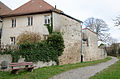
The town of Leutershausen, located on the left bank of the upper Altmühl , was built at the intersection of the former Würzburg - Augsburg and Eichstätt - Nuremberg - Taubertal road. Leutershausen, first mentioned in the year 1000, was probably in the 12./13. It was raised to the status of a city in the 17th century , but it was not passed down as such until 1318. This city, which emerged from a larger village, forms an ellipse that was surrounded by walls and double moats. The city fortifications of the old town, a two-gate complex, was expanded in 1407 and surrounded by an outer ditch filled with fish, which, however, was partially built over from 1739 onwards. Even after the war damage in 1945, which hit the old town and parts of the city fortifications, the fortifications still define the image of the city and its boundaries as an ensemble. The market square, an elongated street market, divides the old town with a slight S-curve and ends at the two city gates. The square emerged from the irregular expansion of the main street; it is characterized by two-storey gabled houses of different heights and widths, the upper storey and gable of which have multiple half-timbering. Around the middle of the 18th century, some hipped roof buildings on the eaves, some with a dwarf house, were added. In the northeast corner of the city is the free, roughly rectangular space in front of the former margravial castle (former "grain box"). The former castle, moved to the north-eastern fortification wall of the old town, is a high three-storey saddle roof building from 1624 with a half-timbered upper floor. Its design is taken by the small, partly plastered or timbered houses of the 17th / 18th centuries. Century, which face the square on the gable side or in the eaves position. A larger gable building completes the castle plan to the southwest. Most of the square itself is paved in the 18th century. In the southeast corner, diagonally opposite on the other side of the city and the main street, the market, is the secluded church square with the free parish church and the former Leonhard chapel (Kirchenplatz 1 and 5). The old paving has also been preserved here and in the adjacent alleys. File number: E-5-71-174-1.
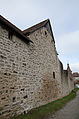
City fortifications
The city fortification of Leutershausen consists of a quarry stone wall with a former kennel that has been preserved all around. A covered battlement has been preserved on the north side. It comes from the Middle Ages and was probably built from 1318. File number: D-5-71-174-1. Starting at the upper gate in the north, the following parts of the city wall have been preserved:

Upper gate

Kirchenplatz 2
Kirchenplatz 3

Badgasse
Badgasse

Badgasse

At the market 23

Lower gate

On plan 6

On plan 2, 3, 4, 5


| location | object | description | File no. | image |
|---|---|---|---|---|
| Am Markt 6 ( location ) |
Upper northern gate | Gate tower, ashlar stone with pointed arch opening, with mansard hipped roof, built-in barbican, medieval core, changed in the 18th century. | D-5-71-174-6 |
 more pictures |
| Am Markt 5 ( location ) |
city wall | D-5-71-174-5 associated | ||
| Kirchenplatz 7 ( location ) |
city wall | D-5-71-174-45 associated | ||
| Kirchenplatz 5 ( location ) |
city wall | D-5-71-174-43 associated | ||
| Kirchenplatz 2 ( location ) |
city wall | D-5-71-174-41 associated | ||
| Badgasse 10 ( location ) |
city wall | D-5-71-174-24 associated | ||
| Am Markt 22 ( location ) |
Lower southern gate | Round quarry stone tower with conical roof, 1525, associated gatehouse, two-storey tent roof construction with passage, early 18th century. | D-5-71-174-13 |
 more pictures |
| Untere Marktgasse 6 ( location ) |
city wall | D-5-71-174-61 associated | ||
| Am Ochsenhof 3 ( location ) |
city wall | D-5-71-174-22 associated | ||
| Plan 6 ( location ) |
city wall | D-5-71-174-55 associated | ||
| Obere Marktgasse 3 ( location ) |
city wall | D-5-71-174-48 associated |
Architectural monuments according to districts
Leutershausen
Within the ensemble
| location | object | description | File no. | image |
|---|---|---|---|---|
| Am Markt 5 ( location ) |
Residential building | Two-storey gable-roof building with a rusticated portal, end of the 17th century. | D-5-71-174-5 | |
| Am Markt 12 ( location ) |
Former Alte Post inn | Two-story hipped roof building with a dwelling and natural stone structure, 18th century. | D-5-71-174-8 |

|
| Am Markt 13 ( location ) |
Residential building | Two-storey gable building with a steep gable roof, labeled "1709". | D-5-71-174-9 |

|
| Am Markt 15 ( location ) |
Residential and commercial building | Two-storey gable-independent saddle roof building, in parts half-timbered, plastered, protruding gable, 17th / 18th centuries Century. | D-5-71-174-10 | |
| Am Markt 26a / 26b ( location ) |
Residential building | Two-storey, gable-independent and plastered saddle roof construction, partly half-timbered, on the courtyard side half-timbered dwarf house with saddle roof, dendronologically dated to 1531, dwarf house 19th / early 20th century. | D-5-71-174-127 | |
| Am Markt 27 ( location ) |
Residential building with pharmacy | Two-storey, eaves saddle roof structure, with natural stone structure and open staircase, around 1870. | D-5-71-174-15 |

|
| Am Markt 29 ( location ) |
Residential and guest house | Two-storey saddle roof construction in corner position, upper storey and gable half-timbered, probably 17th century, the core around 1450. | D-5-71-174-16 |

|
| Am Markt 31 ( location ) |
Former brewery inn, now an inn | Wide-spread, two-storey and gable-independent saddle roof building with a half-timbered upper storey and gable, labeled "1603", "1781" and "1828". | D-5-71-174-18 |

|
| Am Markt 33 ( location ) |
Residential building | Two-storey, gable-independent gable roof building with half-timbered gable, 18th century. | D-5-71-174-19 | |
| Am Ochsenhof 3 ( location ) |
Former tithe barn | Converted to a syringe house, single-storey building with half-hipped roof, tower to the west, half-timbered in parts, 1750. | D-5-71-174-22 | |
| Badgasse 10 ( location ) |
Residential building | Two-storey gable-independent half-hipped roof building, in the core half-timbered, 17th / 18th century. Century. | D-5-71-174-24 |

|
| Badgasse 10 ( location ) |
Economic building | Two-storey L-shaped saddle roof building with half-timbered upper storey, the core of the early 19th century. | D-5-71-174-24 associated | |
| Hans-Schreyer-Straße 24 ( location ) |
Residential buildings | Two-storey, gable-independent saddle roof construction, partly timber-frame, 1836. | D-5-71-174-29 |

|
| Kirchengasse ( location ) |
Market fountain | Neo-Gothic tubular fountain with polygonal basin, cast iron, marked "1852". | D-5-71-174-63 |

|
| Kirchengasse 2 ( location ) |
Residential building | Three-storey gable roof building with eaves, second floor half-timbered, probably second half of the 16th century, ground floor and first floor renovated. | D-5-71-174-34 |
 more pictures |
| Kirchengasse 3 ( location ) |
Residential building | Two-story gable-independent gable roof construction, upper floor and gable half-timbered, with adjoining rear building, single-storeyed gable-roof building with half-timbered gable, probably 18th century. | D-5-71-174-35 |

|
| Kirchengasse 5 ( location ) |
Residential building | Free-standing two-storey flat gable roof building with corner pilasters and cornice structure, east half-timbered extension, 18th century core, lintel marked "1751". | D-5-71-174-36 |

|
| Kirchengasse 6 ( location ) |
Residential building | Two-storey hipped roof building with half-timbered upper storey and dwarf house, edicle-like sandstone portal, marked “1710”; in corner position. | D-5-71-174-37 |

|
| Kirchengasse 8 ( location ) |
Residential building | Two-storey gable-independent gable roof construction, upper storey and gable half-timbered, 1525 ( dendrochronologically dated ), changes probably 17th century. | D-5-71-174-38 |

|
| Kirchengasse 10 ( location ) |
Residential building | Two-storey corner building with a pitched roof and corner blocks, upper storey and gable half-timbered, labeled "1549", changes probably 18th century. | D-5-71-174-39 |

|
| Kirchenplatz 1 ( location ) |
Evangelical Lutheran parish church of St. Peter | Basilica, three-aisled nave with saddle roof and polygonal choir, west tower with pointed helmet, from 1432/33, restoration 1875/77, west tower increased in 1888; with equipment . | D-5-71-174-40 |
 more pictures |
| Kirchenplatz 2 ( location ) |
Dean's office and rectory | Two-storey hipped roof building, central projection with hipped roof dwarf house, with rusticated corner pilasters, 1740/42. | D-5-71-174-41 |

|
| Kirchenplatz 5 ( location ) |
Former St. Leonhard's chapel, now the parish hall | Two-storey gable building with a pitched roof and half-timbered gable, core before 1300, changed first third of the 15th century, half-timbered gable in 1656, later modifications. | D-5-71-174-43 |

|
| Kirchenplatz 7 ( location ) |
Rectory | Two-storey hipped roof building with a dwelling and neo-baroque plaster structure, around 1900. | D-5-71-174-45 |

|
| Kirchenplatz 8 ( location ) |
Parish hall | Three-storey gable roof building with eaves, partly half-timbered, 1525 ( dendrochronologically dated ), changes 18./19. Century. | D-5-71-174-46 |

|
| Obere Marktgasse 3 ( location ) |
Residential buildings | Two-storey gable-independent saddle roof building, upper storey and gable half-timbered, 18th century. | D-5-71-174-48 |

|
| Plan 6 ( location ) |
Former margravial city palace | Four-storey saddle roof construction, quarry stone masonry, with half-timbered parts, round stair tower, 1624, partly built over the city wall. | D-5-71-174-55 |

|
| Untere Marktgasse 1 ( location ) |
Residential building | Two-storey, eaves-standing half-hipped roof building with side half-timbered gable and natural stone structure, 18th century. | D-5-71-174-57 |

|
| Untere Marktgasse 1 ( location ) |
barn | Two-storey saddle roof building, half-timbered, in parts massive, probably first half of the 19th century. | D-5-71-174-57 associated |

|
| Untere Marktgasse 4 ( location ) |
Residential building | Two-storey gable-independent gable roof building, hip to the rear, upper storey and gable half-timbered, rusticated arched portal, late 17th century. | D-5-71-174-59 |

|
| Untere Marktgasse 6 ( location ) |
Former synagogue, now a residential building | Two-storey half-hipped roof building with roof structure of the former synagogue, 1755, conversion to a residential building around 1950. | D-5-71-174-61 |
Outside the ensemble
| location | object | description | File no. | image |
|---|---|---|---|---|
| Altmühl / Schillingsfürster Straße / Staatsstraße 2246 ( location ) |
Bridge over the Altmühl | Three-arched sandstone block structure, around 1770. | D-5-71-174-64 |

|
| At the new Törlein 2 ( location ) |
Residential building | Two-storey half-hipped roof building, partly timber-frame, early 19th century. | D-5-71-174-20 |

|
| Bahnhofstraße, on the road to Wiedersbach ( location ) |
Stone cross, so-called Marstallerkreuz | Medieval. | D-5-71-174-67 | |
| Near Bahnhofstrasse ( location ) |
War memorial 1914/18 | Stone column with a half-relief of a standing soldier, surrounded on both sides by a stone wall with inscription panels, design by Johannes Seiler , erected in 1923, expanded after 1945. | D-5-71-174-2 |

|
| Hans-Schreyer-Strasse 5 ( location ) |
portal | Segmented arch entrance with Art Nouveau front door, marked "1791", front door at the beginning of the 20th century. | D-5-71-174-26 |

|
| Hans-Schreyer-Strasse 17 ( location ) |
Former Heilig Kreuz cemetery church, now the parish hall | Two-storey saddle roof building with roof turrets, under Karl Friedrich von Zocha based on a design by Michael Aschbacher, 1722, later redesigned. | D-5-71-174-28 |

|
| Hans-Schreyer-Strasse 17 ( location ) |
Former cemetery | Created in 1543, with historical gravestones. | D-5-71-174-28 associated |

|
| Hans-Schreyer-Strasse 17 ( location ) |
Churchyard wall | Plastered quarry stone masonry, with memorial stones. | D-5-71-174-28 associated |

|
| Hans-Schreyer-Straße, between No. 20 and 22, at the entrance to the Stadtgraben ( location ) |
Gate pillar | Two stone pillars with pyramids and neo-Gothic ornament. | D-5-71-174-30 |

|
| Jochsberger Straße 10 ( location ) |
graveyard | Established in 1920, extended in 1957, with gravestones in the first half of the 20th century. | D-5-71-174-33 |

|
| Jochsberger Straße 10 ( location ) |
Funeral hall | Single-storey hipped roof building with a strong central projection with a saddle roof and turret with Welscher hood, south-west small corner building with onion hood, in the form of the Heimat style, 1913/20. | D-5-71-174-33 associated | |
| Jochsberger Straße 10 ( location ) |
enclosure | Around 1920, expanded in 1957. | D-5-71-174-33 associated | |
| Near Jochsberger Straße ( location ) |
barn | Massive single-storey saddle roof construction, marked "1774". | D-5-71-174-32 |

|
| Maystrasse 7 ( location ) |
barn | Elongated gable roof building on the eaves side with two storeys, ground floor partly solid, partly half-timbered, upper floor half-timbered, around 1865, extended to the west at the end of the 19th / beginning of the 20th century. | D-5-71-174-128 | |
| Upper suburb 6 ( location ) |
Residential building with butcher shop | Temporary gendarmerie station, two-storey mansard roof building with three-storey corner bay window with tent roof, built before 1826, remodeling after 1904, corner bay window in 1933. | D-5-71-174-198 | |
| Upper suburb 8 ( location ) |
Former residential and craft house | Two-storey, gable-independent half-timbered building with a gable roof, rebuilt after fire in 1608. | D-5-71-174-197 | |
| Obere Vorstadt 12 ( location ) |
Former brewery inn | Two-storey hipped roof building in a corner, courtyard side with half-timbered gable, early 18th century. | D-5-71-174-50 |

|
| Obere Vorstadt 12 ( location ) |
Economic building | Two-storey saddle roof building with half-timbered upper storey, 1822, extension to the north after 1826. | D-5-71-174-50 associated | |
| Obere Vorstadt 12 ( location ) |
barn | Solid construction with a half-hip roof, 18th / first quarter 19th century. | D-5-71-174-50 associated |

|
| Obere Vorstadt 15 ( location ) |
Residential building | Two-storey saddle roof building in corner position, half-timbered, 18th century. | D-5-71-174-52 |

|
| Obere Vorstadt 15 ( location ) |
Outbuilding and barn | Saddle roof buildings, partly half-timbered, probably around 1800. | D-5-71-174-52 associated |

|
| Near Schlesier Straße ( location ) |
Memorial stone to the high court | Stone monolith, 1923. | D-5-71-174-66 |
Atzenhofen
| location | object | description | File no. | image |
|---|---|---|---|---|
| Atzenhofen 2 ( location ) |
barn | Single-storey saddle roof building, half-timbered, probably 18th century. | D-5-71-174-68 |
Büchelberg
| location | object | description | File no. | image |
|---|---|---|---|---|
| Büchelberg 9 ( location ) |
Residential stable house | Single-storey gable-independent building with pitched roof, with half-timbered gable, 17th / 18th centuries Century.
Apparently demolished and replaced by a new building. |
D-5-71-174-69 | |
| Büchelberg 10 ( location ) |
Residential stable house | Single-storey saddle roof building with two-storey dwarf house extension with half-timbering, 18th / 19th centuries Century. | D-5-71-174-70 | |
| On the way towards Erlbach, at the "Lochberg" ( ) |
Atonement stone | Before 1659.
Not re-qualified, not mapped in the Bavarian Monument Atlas. |
D-5-71-174-72 |
Eckartsweiler
| location | object | description | File no. | image |
|---|---|---|---|---|
| Eckartsweiler 4 ( location ) |
Single storey residential stable house | Half-timbered gable, 18./19. Century. | D-5-71-174-73 | |
| Eckartsweiler 4 ( location ) |
Half-timbered barn | Half hip, 18./19. Century. | D-5-71-174-73 associated | |
| Eckartsweiler 5 ( location ) |
Residential stable house | Single-storey massive building with a pitched roof, corner pilasters, gable with floor structure, labeled "1819". | D-5-71-174-74 | |
| Eckartsweiler 9 ( location ) |
Residential stable house | Single-storey building with a pitched roof, half-timbered gable, labeled "1723". | D-5-71-174-75 | |
| Eckartsweiler 17 ( location ) |
Former stable house | Two-storey saddle roof building with half-timbered upper floor and half-timbered gable, 1705. | D-5-71-174-76 | |
| Eckartsweiler 21 ( location ) |
Former farmhouse | Single-storey, massive gable roof construction with a two-storey transverse gable, corner cuboids, labeled "1866", with a half-timbered extension at the same time. | D-5-71-174-126 |
Oak wood
| location | object | description | File no. | image |
|---|---|---|---|---|
| Eichholz 5 ( location ) |
Residential stable house | Single-storey building with a pitched roof, half-timbered gable, first half of the 19th century. | D-5-71-174-77 | |
| Hundsücken, on the northeastern edge of the village ( location ) |
Stone cross | Late medieval, sandstone. | D-5-71-174-78 |

|
Erlbach
| location | object | description | File no. | image |
|---|---|---|---|---|
| Erlbach 2 ( location ) |
Dreiseithof, residential stable house | Single-storey saddle roof building with a two-storey dwelling with half-timbering, 18th / 19th centuries Century. | D-5-71-174-79 | |
| Erlbach 2 ( location ) |
Dreiseithof, barn | Single-storey saddle roof construction, one side with a crooked hip, in parts half-timbered, labeled "1905". | D-5-71-174-79 associated | |
| Erlbach 2 ( location ) |
Dreiseithof, stable building, barn | Single-storey saddle roof construction, around 1900. | D-5-71-174-79 associated |
Erndorf
| location | object | description | File no. | image |
|---|---|---|---|---|
| Erndorf 3 ( location ) |
Simonsmühle, mill and residential building | Two-storey building with a half-hipped roof, with half-timbered gable, 1700, marked "1790". | D-5-71-174-80 |
Frommetsfelden
| location | object | description | File no. | image |
|---|---|---|---|---|
| Altmühl ( location ) |
Stone bridge over the Altmühl | Four-arch sandstone cuboid bridge, probably 16./17. Century, the eastern arch renewed and inscribed "1824". | D-5-71-174-83 | |
| Hürbeler Straße 2 ( location ) |
Former inn | Two-storey, gable-independent saddle roof construction, partly timber-frame, labeled "1821". | D-5-71-174-81 | |
| Hürbeler Straße 3 ( location ) |
Evangelical Lutheran Parish Church of Sankt Erhard | Medieval choir tower, nave with a steep gable roof and massive rectangular tower with pyramid roof, 13 in the core.
Century, tower 1584, restored 1661; with equipment . |
D-5-71-174-82 | |
| Hürbeler Straße 3 ( location ) |
Cemetery edging | Ashlar stone wall, medieval core. | D-5-71-174-82 associated |
Görchsheim
| location | object | description | File no. | image |
|---|---|---|---|---|
| Görchsheim 1 ( location ) |
barn | Single-storey saddle roof structure, fragments of a mill, broken stone and ashlar stone, 18th century. | D-5-71-174-85 |
Gutenhard
| location | object | description | File no. | image |
|---|---|---|---|---|
| Gutenhard 3 ( location ) |
Coat of arms stone | 1755. | D-5-71-174-86 | |
| Gutenhard 4 ( location ) |
Farmhouse, residential building | Two-storey gable roof construction, plaster structure, marked with "1787" and "1922". | D-5-71-174-87 | |
| Gutenhard 5 ( location ) |
Coat of arms stone | 1767. | D-5-71-174-88 |
Hannenbach
| location | object | description | File no. | image |
|---|---|---|---|---|
| Railway line Nuremberg – Schnelldorf, at kilometer 53.073 ( location ) |
Railway bridge | Single-arched sandstone cuboid bridge with profiling, around 1875/76. | D-5-71-174-200 | |
| Hannenbach 12 ( location ) |
Stable house of a farm | Single-storey saddle roof building with plastered gable house, 18th / 19th centuries Century. | D-5-71-174-89 | |
| Hannenbach 12 ( location ) |
barn | Gable roof construction, half-timbered, 18th century. | D-5-71-174-89 associated |
Backwood
| location | object | description | File no. | image |
|---|---|---|---|---|
| Gumbertusbach, east of the village in the forest ( location ) |
Gumbertus spring | Old frame, natural stone cuboid, with modern, renewed well house, small massive gable roof building. | D-5-71-174-92 | |
| Hinterholz 2 ( location ) |
oven | Cast iron, 18th century. | D-5-71-174-90 | |
| In Hinterholz, in the place ( location ) |
Stone cross | Medieval. | D-5-71-174-91 |

|
Wood mill
| location | object | description | File no. | image |
|---|---|---|---|---|
| Holzmühle 1 ( location ) |
Former wood mill, residential building | Two-storey saddle roof building with plastered structure and half-timbered gable, 18th century, marked "1818". | D-5-71-174-93 | |
| Holzmühle 1 ( location ) |
Former wood mill, barn | Massive gable roof construction, one-sided with a crooked hip, with half-timbered gable, 1801. | D-5-71-174-93 associated |
Hundshof
| location | object | description | File no. | image |
|---|---|---|---|---|
| Hundshof 1 ( location ) |
House of a farm | Two-storey saddle roof building, plastered half-timbered gable, probably from the late 18th century. | D-5-71-174-94 | |
| Hundshof 1 ( location ) |
barn | One-storey building with a half-hip roof, half-timbered parts, probably at the same time. | D-5-71-174-94 associated |
Jochsberg
| location | object | description | File no. | image |
|---|---|---|---|---|
| Altmühl ( location ) |
Bridge over the Altmühl | Three-arched sandstone block construction, 18th century. | D-5-71-174-102 |

|
| Brauhausweg 1 ( location ) |
Residential buildings | Two-story massive hipped roof building with corner pilasters and floor structure, 18th century, formerly part of the castle.
Barn, one-story building with a crooked hip roof, around 1800 |
D-5-71-174-95 | |
| Am Ring 1 ( location ) |
barn | One-storey hipped roof building with bat dormers and corner blocks, around 1800. | D-5-71-174-95 associated | |
| Brauhausweg 2 ( location ) |
Residential buildings | Two-storey hipped roof building in corner position, with half-timbered upper storey, 18th century. | D-5-71-174-96 | |
| Brauhausweg 5 ( location ) |
Former castle brewery | Two-storey half-hipped roof building with corner pilaster strips, keystone marked "1783". | D-5-71-174-97 | |
| Near Am Ring ( location ) |
barn | Single-storey solid building with a half-hipped roof and corner blocks, 18th century, renovated in 1898. | D-5-71-174-97 associated | |
| Burgweg 3 ( location ) |
Remains of a castle, barn | Single-storey half-timbered building with a gable roof, using castle masonry, 17th / 18th centuries Century, with an older core, including a barrel-vaulted castle cellar, 1315. | D-5-71-174-98 | |
| Burgweg 3/2 ( location ) |
Remains of a castle, fortification of the castle mound | Quarry stone slope, probably 14th century. | D-5-71-174-98 associated | |
| Dorfplatz 2 ( location ) |
Former inn | Two-storey eaves side building with saddle roof and half-timbered upper storey and gable, 1767. | D-5-71-174-99 | |
| Dorfplatz 2 ( location ) |
Attached barn | Two-storey saddle roof building with half-timbered upper storey, labeled "1767". | D-5-71-174-99 associated | |
| Dorfplatz 8 ( location ) |
Evangelical Lutheran Parish Church of St. Mauritius | Hall building with gable roof and three-sided closure, facade tower with pointed helmet, 14./15. Century, gallery 17th century; with equipment . | D-5-71-174-100 |
 more pictures |
| Dorfplatz 8 ( location ) |
graveyard | The core is a medieval complex with gravestones. | D-5-71-174-100 associated | |
| Dorfplatz 8 ( location ) |
Cemetery wall | The core is medieval, plastered quarry stone masonry and arched portal with rich volute gable top, around 1600. | D-5-71-174-100 associated |

|
| Kreisstraße 3 ( location ) |
Bridge over the Altmühl | Single-arched sandstone block, 18th century. | D-5-71-174-101 | |
| Protective ditch at the Wolfsmühle ( location ) |
Bridge over the Altmühl | Single-arched sandstone block, 18th century. | D-5-71-174-103 |
Mittelramstadt
| location | object | description | File no. | image |
|---|---|---|---|---|
| Weinstrasse, at the western exit of the village at the fork in the road to Auerbach and Bauzenweiler ( location ) |
Stone cross | Sandstone, medieval. | D-5-71-174-104 |

|
Neunkirchen near Leutershausen
| location | object | description | File no. | image |
|---|---|---|---|---|
| Kirchenweg 9 ( location ) |
Evangelical Lutheran Parish Church of St. George | Hall building with hipped gable roof and rectangular choir, choir flank tower with tented roof, tower and choir 14th century, hall with galleries 1734; with equipment . | D-5-71-174-105 |
,_St._Georgskirche.JPG) more pictures |
| Kirchenweg 9 ( location ) |
graveyard | Medieval layout, changes probably 18th / 19th centuries. Century, with historical tombstones. | D-5-71-174-105 associated | |
| Kirchenweg 9 ( location ) |
Walling | Probably at the same time. | D-5-71-174-105 associated | |
| Pfarrstrasse 4 ( location ) |
Rectory | Two-storey gable roof building, hipped to the west, in parts half-timbered, mid-18th century. | D-5-71-174-106 | |
| Pfarrstrasse 4 ( location ) |
Parish barn | Half-timbered building with a gable roof hipped on one side, 18th century. | D-5-71-174-106 associated | |
| Near Wiesenstraße, on the access road to the district road north of the railway underpass ( location ) |
Four stone crosses | Partly fragmentary, probably medieval. | D-5-71-174-107 |

|
Oberramstadt
| location | object | description | File no. | image |
|---|---|---|---|---|
| Lehrberger Strasse 1 ( location ) |
Former stable house | Single-storey massive building with a pitched roof, plaster structure, 18th century. | D-5-71-174-109 |
Rammersdorf
| location | object | description | File no. | image |
|---|---|---|---|---|
| Hoffeld ( location ) |
mausoleum | Tomb of the Barons von Eyb , hall building with a gable roof, three-sided closure and vestibule on a stepped platform, early 20th century. | D-5-71-174-133 | |
| Rammersdorf 1 ( location ) |
Rammersdorf Castle, moated castle | Moated castle, three-storey hipped roof building with bat dormers and roof turrets with Welscher hood, by Gabriel de Gabrieli , 1715.
Reconditioning was awarded the monument protection medal 2018 |
D-5-71-174-110 |
 more pictures |
| Rammersdorf 1 ( location ) |
Rammersdorf Castle, moat | Quarry stone framed walls with two gate pillars at the same time. | D-5-71-174-110 associated | |
| Rammersdorf 1 ( location ) |
Rammersdorf Castle, moat bridge | Two-arched sandstone block construction, at the same time. | D-5-71-174-110 associated | |
| Rammersdorf 2 ( location ) |
Rammersdorf Castle, outbuilding | Two-storey saddle roof construction, partly half-timbered, 18th / 19th centuries Century. | D-5-71-174-110 associated | |
| In Rammersdorf ( location ) |
Rammersdorf Castle, Castle Park | Park with bars, 18th / early 19th century. | D-5-71-174-110 associated | |
| Rammersdorf 2; Rammersdorf 1; In Rammersdorf ( location ) |
Rammersdorf Castle, entrance | Sandstone block wall and rectangular goal posts with ball attachments, 18th / early 19th century. | D-5-71-174-110 associated | |
| Rammersdorf 2 ( location ) |
Rammersdorf Castle, barn | Elongated half-timbered building with a gable roof, 18th / early 19th century, extended to the west after 1826. | D-5-71-174-110 associated | |
| Rammersdorf 2 ( location ) |
Rammersdorf Castle, outbuilding | One-storey hipped roof building with bat dormers, partly solid, partly half-timbered, 18th / early 19th century. | D-5-71-174-110 associated |
Saxony
| location | object | description | File no. | image |
|---|---|---|---|---|
| Oberer Weiler 21 ( location ) |
Farm building to the former brewery | Two-storey saddle roof construction, with truss parts, 17th-18th centuries Century. | D-5-71-174-111 | |
| Oberer Weiler 21 ( location ) |
barn | Saddle roof construction, in parts half-timbered, 18./19. Century. | D-5-71-174-111 associated | |
| Oberer Weiler 21 ( location ) |
Basement house / barn | Single-storey saddle roof building, half-timbered structure, plinth of natural stone cuboid, probably 19th century. | D-5-71-174-111 associated |
Disappearance
| location | object | description | File no. | image |
|---|---|---|---|---|
| Hanswillenfeld, about 500 meters outside the village on a dirt road ( location ) |
Stone cross | Medieval. | D-5-71-174-113 |

|
| Schwand 5 ( location ) |
Residential stable house | Single-storey building with a pitched roof, in parts half-timbered, 17th / 18th centuries Century. | D-5-71-174-112 | |
| Schwand 5 ( location ) |
barn | Single-storey saddle roof construction, half-timbering over a solid base, probably at the same time. | D-5-71-174-112 associated |
Steinberg
| location | object | description | File no. | image |
|---|---|---|---|---|
| Steinberg 9 ( location ) |
Farmhouse | Single-storey saddle roof building, dwarf house, with structure partly in natural stone, labeled "1802". | D-5-71-174-114 |
Tiefenthal
| location | object | description | File no. | image |
|---|---|---|---|---|
| Spitzfeld, on the Neunkirchen – Hinterholz route ( location ) |
Stone cross | Medieval. | D-5-71-174-108 |

|
Weißenkirchberg
| location | object | description | File no. | image |
|---|---|---|---|---|
| Kirchbuck 13 ( location ) |
Evangelical Lutheran Parish Church of St. Wenceslas, Margrave Church | Hall church, choir and tower from the late Middle Ages, nave according to plans by Carl Friedrich von Zocha , 1728, tower with pointed helmet; with equipment . | D-5-71-174-116 |
 more pictures |
| Kirchbuck 11 ( location ) |
graveyard | Late medieval complex with defensive wall; with tombstones. | D-5-71-174-116 associated | |
| Kirchbuck 15 ( location ) |
Rectory | Two-storey saddle roof building with rusticated corner pilasters and plastered structures, 1780. | D-5-71-174-117 |

|
| Kirchbuck 3 ( location ) |
Parish barn | One-storey building with a half-hipped top, with a coat of arms stone, marked "1785". | D-5-71-174-117 associated (formerly D-5-71-174-115) | |
| Near Weiherstrasse ( location ) |
Former sheep barn | Single-storey building with half-hipped roof, half-timbered, around 1700. | D-5-71-174-118 |
Wiedersbach
| location | object | description | File no. | image |
|---|---|---|---|---|
| Dorfstraße 39, on the outskirts ( location ) |
graveyard | Plant first third of the 20th century. | D-5-71-174-119 | |
| Dorfstraße 39, on the outskirts ( location ) |
Cemetery wall | At the same time; with tombstones. | D-5-71-174-119 associated | |
| Near the village road ( ) |
Black Eagle Inn | Two-storey, plastered solid building with a crooked hip roof, 1766; with boom. | D-5-71-174-123 | |
| Near the village road ( ) |
Massive barn with a hipped roof | Probably the same time. | D-5-71-174-123 associated | |
| Hauptstrasse 1 ( location ) |
Evangelical Lutheran branch church, former church of the Barons von Eyb | Hall church, choir tower probably still late Romanesque, nave and tower extension 18th century, located in the former castle area; with equipment . | D-5-71-174-120 |
 more pictures |
| Hauptstrasse 1 ( location ) |
enclosure | Probably the 18th century. | D-5-71-174-120 associated |

|
| Hauptstrasse 3 ( location ) |
Former castle property of the Barons von Eyb | Two-storey hipped roof building, probably around 1800. | D-5-71-174-121 | |
| Hauptstrasse 7 ( location ) |
Gatekeeper cottage | Single-storey saddle roof building with half-timbered upper storey, probably around 1800. | D-5-71-174-121 associated | |
| Hauptstrasse 3 ( location ) |
barn | Massive saddle roof construction, broken and ashlar stones, 17th / 18th centuries Century. | D-5-71-174-121 associated | |
| Hauptstrasse 3/5 ( location ) |
enclosure | Partly surrounded by quarry stone wall with gate openings, 1675, changes probably 19th century. | D-5-71-174-121 associated | |
| Stumpfwiesen / Hauptstraße 7 ( location ) |
Preserved parts of the pond reinforcement | 17./18. Century. | D-5-71-174-121 associated | |
| Hauptstrasse 9 ( location ) |
Residential buildings | Two-story hipped roof building, 18th century. | D-5-71-174-122 |
Former architectural monuments
This section lists objects that were previously entered in the list of monuments.
| location | object | description | File no. | image |
|---|---|---|---|---|
| Leutershausen Am Markt 1 ( location ) |
town hall | Two-storey saddle roof building in corner position, 1785, modernized. | D-5-71-174-3 |

|
| Leutershausen Am Markt 2 ( location ) |
Gabled house belonging to the town hall | Terracotta decor, marked "1936". | D-5-71-174-4 |

|
| Leutershausen Am Markt 30 ( location ) |
Residential buildings | Two-storey gable-independent gable roof building, with half-timbered gable, 17th / 18th centuries Century. | D-5-71-174-17 |

|
| Leutershausen Hans-Schreyer-Strasse 13 ( location ) |
portal | 1843. | D-5-71-174-27 |

|
| Leutershausen Hans-Schreyer-Strasse (at numbers 25 a and 25 b) ( location ) |
bridge | Single arched rectangular building, 18th century. | D-5-71-174-65 | |
| Leutershausen Obere Vorstadt 13 ( location ) |
Residential building | Two-story building with a half-hip roof, 18th / 19th centuries Century. | D-5-71-174-51 | |
| Büchelberg Büchelberg 12 ( location ) |
Single storey residential stable house | Half-timbered structure, 17th century, extension probably 18th century. | D-5-71-174-71 | |
|
Froschmühle About 200 m to the northwest, on the Leutershausen - Winden footpath ( ) |
Stone cross | Medieval. | D-5-71-174-84 | |
| Wiedersbach Gründleinsbach, Hauptstraße, in the direction of Ansbach located district ( ) |
Cuboid bridge | Single curve, with profiling, around the middle of the 19th century. | D-5-71-174-124 |
Lost monuments
This section lists objects that were previously entered in the list of monuments, but no longer exist.
| location | object | description | File no. | image |
|---|---|---|---|---|
| Leutershausen Untere Marktgasse 3 ( location ) |
Residential building | Single-storey building with a pitched roof, corner position, with plastered half-timbered gable, 1545 (dendrochronologically dated), half-timbered south gable 1729 (dendrochronologically dated), ground floor massively renewed.
Canceled in 2014. |
D-5-71-174-58 |

|
| Leutershausen Untere Marktgasse 3 ( ) |
Outbuildings | Two-storey saddle roof building, probably 19th century.
Canceled in 2014. |
D-5-71-174-58 |
See also
Remarks
- ↑ This list may not correspond to the current status of the official list of monuments. The latter can be viewed on the Internet as a PDF using the link given under web links and is also mapped in the Bavarian Monument Atlas . Even these representations, although they are updated daily by the Bavarian State Office for Monument Preservation , do not always and everywhere reflect the current status. Therefore, the presence or absence of an object in this list or in the Bavarian Monument Atlas does not guarantee that it is currently a registered monument or not. The Bavarian List of Monuments is also an information directory. The property of a monument - and thus the legal protection - is defined in Art. 1 of the Bavarian Monument Protection Act (BayDSchG) and does not depend on the mapping in the Monument Atlas and the entry in the Bavarian Monument List. Objects that are not listed in the Bavarian Monument List can also be monuments if they meet the criteria according to Art. 1 BayDSchG. Early involvement of the Bavarian State Office for Monument Preservation according to Art. 6 BayDSchG is therefore necessary in all projects.
Individual evidence
- ↑ BLfD: Monument Protection Medal 2018 , page 14, accessed on July 31, 2018.
literature
- Hans Wolfram Lübbeke: Middle Franconia . Ed .: Michael Petzet , Bavarian State Office for the Preservation of Monuments (= Monuments in Bavaria . Volume V ). Oldenbourg, Munich 1986, ISBN 3-486-52396-1 .
Web links
- List of monuments for Leutershausen (PDF) at the Bavarian State Office for Monument Preservation
- Leutershausen in the Bavarian Monument Atlas

Adelshofen | Arberg | Aurach | Bechhofen | Bruckberg | Book at the forest | Burgoberbach | Burk | Colmberg | Dentlein am Forst | Diebach | Dietenhofen | Dinkelsbühl | Dombühl | Dürrwangen | Ehingen | Feuchtwangen | Flachslanden | Gebsattel | Gerolfingen | Geslau | Heilsbronn | Herrieden | Insingen | Langfurth | Lehrberg | Leutershausen | Lichtenau | Merkendorf | Mitteleschenbach | Mönchsroth | Neuendettelsau | Neusitz | Oberdachstetten | Ohrbach | Ornbau | Petersaurach | Röckingen | Rothenburg ob der Tauber | Rügland | Saxony near Ansbach | Schillingsfürst | Schnelldorf | Schopfloch | Steinsfeld | Unterschwaningen | Wassertrüdingen | Weidenbach | Weihenzell | Weiltingen | Wettringen | Wieseth | Wilburgstetten | Windelsbach | Windsbach | Wittelshofen | Wolframs-Eschenbach | Wörnitz