List of architectural monuments in Duderstadt (outer districts)
The list of architectural monuments in Duderstadt (outer districts) includes listed buildings in the districts of the Lower Saxony city of Duderstadt ( district of Göttingen ). The list is as of 1997.
General
Duderstadt is mentioned for the first time in 927 in a deed of gift from King Henry I. There is no longer an original of this document; the copy dates from 929, the official year Duderstadt was founded.
This article contains a list of the architectural monuments in Breitenberg , Brochthausen , Desingerode , Esplingerode , Fuhrbach , Gerblingerode , Hilkerode , Immingerode , Langenhagen , Mingerode , Nesselröden , Tiftlingerode , Werxhausen and Westerode . The architectural monuments of Duderstadt are listed in the list of architectural monuments in Duderstadt .
The columns contain the following information:
- Location: the address of the monument and the geographical coordinates . Map view to set coordinates . In the map view, monuments without coordinates are shown with a red marker and can be set on the map. Architectural monuments without a picture are marked with a blue marker, architectural monuments with a picture with a green marker.
- Official name: Name of the monument
- Description: the description of the monument. Under § 3 (2) NDSchG individual monuments and under § 3 (3) NDSchG groups of structures and their components are shown.
- ID: the number of the monument
- Image: a picture of the monument
Breitenberg
| location | designation | description |
ID |
image |
|---|---|---|---|---|
| 51 ° 33 ′ 16 "N, 10 ° 16 ′ 49" E | Forester's lodge Hübental | 35180428 | ||
| Lange Straße 9 51 ° 32 ′ 47 ″ N, 10 ° 17 ′ 20 ″ E |
Residential building | 35180512 | ||
| Marienstraße 21 51 ° 32 ′ 50 ″ N, 10 ° 17 ′ 21 ″ E |
Residential building | 35180768 | ||
| Schmiedestrasse 1 51 ° 32 ′ 48 ″ N, 10 ° 17 ′ 14 ″ E |
Residential building | 35180598 | ||
| Turmstrasse 2 51 ° 32 ′ 47 ″ N, 10 ° 17 ′ 12 ″ E |
Catholic parish church of the Annunciation | The Church of the Annunciation was built in 1896 in a neo-Gothic style. The brick building was designed by Paschalis Gratze . | 35180641 |

|
| Turmstrasse 4 51 ° 32 ′ 46 ″ N, 10 ° 17 ′ 9 ″ E |
House in a courtyard | 35180748 |
Brochthausen
| location | designation | description |
ID |
image |
|---|---|---|---|---|
| Brochthäuser Strasse 75 51 ° 32 ′ 52 ″ N, 10 ° 21 ′ 34 ″ E |
Residential building | 35180908 |

|
|
| Brochthäuser Strasse 83 51 ° 32 ′ 49 ″ N, 10 ° 21 ′ 33 ″ E |
Residential building | 35180928 |

|
|
| Reeke 10 51 ° 32 '57 "N, 10 ° 21' 35" E |
church | The catholic brick church St. Georg was built in the neo-Gothic style in 1891/92. The three-aisled hall church is spanned with a ribbed vault, to the west is a tower with a pointed helmet. Inside there are four pillar figures from the second half of the 18th century, the interior painting was restored in 1989–91. | 35180948 |

|
Desingerode
| location | designation | description |
ID |
image |
|---|---|---|---|---|
| Burgstrasse 7/9 51 ° 31 ′ 30 ″ N, 10 ° 10 ′ 47 ″ E |
Wayside shrine | 35180991 | ||
| Desingeröder Strasse 45 51 ° 31 ′ 28 ″ N, 10 ° 10 ′ 52 ″ E |
Wayside shrine | The wayside shrine is at the exit to Werxhausen. It is about 1.90 meters high, made of sandstone and bears the date 1678. The shaft is transversely rectangular when viewed from above, it tapers slightly towards the top and carries an attachment above an ionizing capital on which Saint Urban is in the south Pope's robe is shown. This page points to the former Desingerode branch village Werxhausen, whose church is dedicated to Saint Urban. On the other sides, the Desingerode patron saint St. Mauritius, St. Andrew and a crucifixion group are shown. The shaft is decorated with scale-like foliage. | 35181142 |

|
| 51 ° 31 '42 "N, 10 ° 11' 24" E | Wayside shrine | The wayside shrine is on the road to Esplingerode. This wayside shrine is over 3.30 meters high and made of light sandstone. It is inscribed and dated to the year 1741. On the sides of the lantern, Saint Michael, Saint John of Nepomuk and a crucifixion group are depicted. The shaft of the wayside shrine shows the tools of the Passion and the symbols of Christ. |

|
|
| Desingeröder Strasse 7 51 ° 31 ′ 37 ″ N, 10 ° 11 ′ 11 ″ E |
Farm buildings | |||
| Desingeröder Strasse 8 51 ° 31 ′ 38 ″ N, 10 ° 11 ′ 10 ″ E |
Wayside shrine |

|
||
| Desingeröder Straße 33 |
Residential building | |||
| Desingeröder Straße 42 |
Rectory | |||
| Desingeröder Straße 44 |
court | |||
| Mauritiusstraße 4 |
Residential building | |||
| Mauritiusstraße 5 |
Residential building | |||
| Mauritiusstraße 6 |
Residential building | |||
| Mauritiusstraße 9 |
Residential building | |||
| Mauritiusstrasse 11 51 ° 31 ′ 30 ″ N, 10 ° 10 ′ 55 ″ E |
Catholic Church of St. Mauritius | The current church was built from 1752 to 1754 in place of a previous building from the 16th century. |

|
|
| Von-Wehren-Straße 51 ° 31 ′ 37 ″ N, 10 ° 11 ′ 15 ″ E |
Wayside shrine | Inscription dated 1868 and attributed to the stone carver H. Vollmer from Westerode. Originally located on a dirt road |

|
Esplingerode
| location | designation | description |
ID |
image |
|---|---|---|---|---|
| Püttegasse 51 ° 32 ′ 17 ″ N, 10 ° 11 ′ 24 ″ E |
Wayside shrine | 35199321 | ||
| Esplingeröder Strasse 2 51 ° 31 ′ 57 ″ N, 10 ° 11 ′ 47 ″ E |
Residential building | A farm house was built in 1793. | 35199174 | |
| Esplingeröder Strasse 3 51 ° 31 ′ 55 ″ N, 10 ° 11 ′ 48 ″ E |
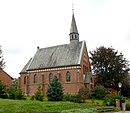
chapel | The Catholic Chapel of St. George was built in 1913 from brick masonry in a neo-Gothic style according to plans by Franz Huch. The three-axis building with a retracted polygonal choir carries a slated roof turret. | 35199195 |
|
| Esplingeröder Strasse 30 51 ° 32 ′ 3 ″ N, 10 ° 11 ′ 36 ″ E |
Residential building | 35199259 | ||
| Esplingeröder Strasse 41 51 ° 32 ′ 2 ″ N, 10 ° 11 ′ 31 ″ E |
Wrought | 35199281 |
Fuhrbach
| location | designation | description |
ID |
image |
|---|---|---|---|---|
| At Tower 2 51 ° 31 ′ 50 ″ N, 10 ° 20 ′ 21 ″ E |
St. Pankratius Church | The neo-Romanesque Catholic Church of St. Pankratius was built from sandstone ashlar masonry in 1873–76 according to plans by Anton Algermissen. It has a basilical cross-section and ends with a flat wooden beam ceiling. The plastered tower was erected separately from the church in 1956. | 35199366 |

|
| At tower 7/9 51 ° 31 ′ 49 ″ N, 10 ° 20 ′ 20 ″ E |
school | 35199387 | ||
| Fuhrbacher Strasse 51 ° 31 ′ 22 ″ N, 10 ° 19 ′ 49 ″ E |
Wayside shrine | 35199449 | ||
| Bleicheröder Strasse 999 51 ° 32 ′ 5 ″ N, 10 ° 20 ′ 51 ″ E |
court | The so-called Paterhof belonged to the Gerode monastery . The gatehouse is a two-story half-timbered house with a half-hipped roof. There is an archway in the middle of the facade and four windows can be seen above the archway. Otherwise the facade is asymmetrical. | 35199470 | |
| Bleicheröder Strasse / Fuhrbacher Strasse 51 ° 31 ′ 53 ″ N, 10 ° 20 ′ 27 ″ E |
Brook | 35199408 |
Gerblingerode
| location | designation | description |
ID |
image |
|---|---|---|---|---|
| Brunnenstrasse 30 51 ° 29 ′ 41 ″ N, 10 ° 15 ′ 38 ″ E |
Residential building | 35199582 | ||
| Gerblingeröder Strasse 2 51 ° 29 ′ 54 ″ N, 10 ° 15 ′ 40 ″ E |
Wayside shrine | 35199730 | ||
| Gerblingeröder Strasse 51 ° 29 ′ 40 ″ N, 10 ° 15 ′ 43 ″ E |
Sandstone pillars | 35199709 | ||
| Gerblingeröder Strasse 46 51 ° 29 ′ 40 ″ N, 10 ° 15 ′ 43 ″ E |
church | 45258535 |
 More pictures |
|
| Gerblingeröder Strasse 61/63 51 ° 29 ′ 42 ″ N, 10 ° 15 ′ 43 ″ E |
Residential building | 35199751 | ||
| Gerblingeröder Strasse 81 51 ° 29 ′ 39 ″ N, 10 ° 15 ′ 43 ″ E |
Residential building | 35199794 | ||
| 51 ° 29 ′ 20 "N, 10 ° 14 ′ 43" E | Horse observatory | The horse mountain station is part of the Duderstädter Landwehr, a wall-ditch system. | 35199622 |
 More pictures |
| Teistunger Strasse 16 51 ° 29 ′ 35 ″ N, 10 ° 15 ′ 43 ″ E |
Residential building | 35199814 | ||
| B 247, km 28.090 51 ° 29 ′ 59 "N, 10 ° 15 ′ 52" E |
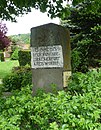
Landmark | Show the historical border between Hanover and Thuringia. | 35199601 |
|
Hilkerode
| location | designation | description |
ID |
image |
|---|---|---|---|---|
| Alte Straße 3 51 ° 33 ′ 36 ″ N, 10 ° 18 ′ 29 ″ E |
Residential building | 35199874 | ||
| Alte Straße 7 51 ° 33 ′ 37 ″ N, 10 ° 18 ′ 30 ″ E |
Residential building | 35199894 | ||
| Alte Straße 27 51 ° 33 ′ 40 ″ N, 10 ° 18 ′ 31 ″ E |
Residential building | 35199915 | ||
| Am Anger 7 51 ° 33 '36 "N, 10 ° 18" 35 "E |
Residential building | |||
| Am Euwer 2 51 ° 33 ′ 37 ″ N, 10 ° 18 ′ 41 ″ E |
Residential building | 35199957 | ||
| An St. Johannes 13 51 ° 33 ′ 36 "N, 10 ° 18 ′ 32" E |
Residential building | 35199977 | ||
| Lane 3 51 ° 33 ′ 40 ″ N, 10 ° 18 ′ 35 ″ E |
Residential building | 35199997 | ||
| Hilkeröder Strasse 19 51 ° 33 ′ 32 ″ N, 10 ° 18 ′ 36 ″ E |
Residential building | 35200017 | ||
| Hilkeröder Strasse 26/28 51 ° 33 ′ 32 ″ N, 10 ° 18 ′ 37 ″ E |
Residential building | 35180016 | ||
| Hilkeröder Strasse 35 51 ° 33 ′ 37 ″ N, 10 ° 18 ′ 38 ″ E |
Residential building | 35200081 | ||
| Im Ellertal 3 51 ° 33 ′ 44 ″ N, 10 ° 18 ′ 38 ″ E |
Residential building | 35200101 |
Immingerode
| location | designation | description |
ID |
image |
|---|---|---|---|---|
| Bardowickstrasse 6 51 ° 29 ′ 16 ″ N, 10 ° 13 ′ 57 ″ E |
Four-sided courtyard | 35180030 | ||
| Böseckendorfer Strasse 6 51 ° 29 ′ 22 ″ N, 10 ° 13 ′ 54 ″ E |
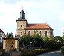
Catholic Church of St. John Baptist | Erected 1717-21 as a hall church made of sandstone ashlar masonry, the west tower is medieval in its core. High altar dated 1745, pulpit from the middle of the 17th century. | 35180047 |
|
| Böseckendorfer Strasse 8 51 ° 29 ′ 22 ″ N, 10 ° 13 ′ 53 ″ E |
Sexton's house | 35203519 | ||
| Immingeröder Strasse 8 51 ° 29 ′ 25 ″ N, 10 ° 14 ′ 1 ″ E |
barn | 35204166 | ||
| Immingeröder Strasse 8 51 ° 29 ′ 25 ″ N, 10 ° 14 ′ 3 ″ E |
Residential building | 35204124 | ||
| At the clus 51 ° 29 ′ 22 ″ N, 10 ° 13 ′ 49 ″ E |
chapel | In the second half of the 19th century, the successor to a chapel built in 1682/83 on the occasion of a plague epidemic. | 35203716 |

|
| Way of the Cross | The way of the cross on the horse mountain was created at the end of the 19th century. It closes with a sandstone crucifix with an inscription dated 1904. |

|
||
| Horse mountain |
Trench wall system | The rampart is located on the horse mountain . |

|
Langenhagen
| location | designation | description |
ID |
image |
|---|---|---|---|---|
| Kirchweihstrasse 1 51 ° 32 ′ 21 ″ N, 10 ° 19 ′ 21 ″ E |
Catholic Church | 35200165 |

|
|
| Langenhäger Strasse 51 ° 31 ′ 57 ″ N, 10 ° 19 ′ 31 ″ E |
Wayside shrine | 35200186 | ||
| Langenhäger Strasse 33 51 ° 32 ′ 24 ″ N, 10 ° 19 ′ 17 ″ E |
Residential building | 35200207 |
Mingerode
| location | designation | description |
ID |
image |
|---|---|---|---|---|
| Bachstrasse 1 51 ° 32 ′ 10 ″ N, 10 ° 14 ′ 27 ″ E |
restaurant | |||
| Bachstraße 6 |
Courtyard (house, barn, stable) | |||
| Bachstraße 12 |
Courtyard (house, barn, stable) | |||
| Bachstraße 34 |
Residential building (a former courtyard) | |||
| Lindenallee 1 |
Residential building | |||
| Lindenallee 2 |
Residential building | |||
| Lindenallee 6 |
Residential building | |||
| Lindenallee 8 |
Residential building | |||
| Lindenallee 10 |
Residential building | |||
| Lindenallee 14 |
Residential building | tore off | ||
| Mingeröder Straße 7 |
Residential building | |||
| Mingeröder Straße 35 |
school | |||
| Mingeröder Straße 47 |
Residential building | |||
| St. Andreas Strasse 51 ° 32 ′ 11 ″ N, 10 ° 14 ′ 38 ″ E |
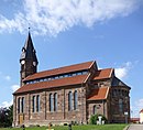
Catholic Church | The relatively large neo-Romanesque church of St. Andreas was built from sandstone blocks in 1872/73. The basilical cross-section with a wooden flat ceiling has, as a special feature, very slim, widely spaced supports that support the wooden construction of the upper aisle with the flat upper aisle windows. Inside there is a late Gothic carved altar and six Baroque figures of saints. |
|
|
| St.-Andreas-Straße 7 |
Residential building |
Nettles
| location | designation | description |
ID |
image |
|---|---|---|---|---|
| Georgstrasse 51 ° 29 ′ 44 ″ N, 10 ° 11 ′ 2 ″ E |
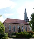
St. George Church | The Catholic parish church of St. Georg was added to the tower of a previous building in 1853. The hall, made of sandstone blocks, was built by the Duderstadt master builder L. Windhausen. Inside there is a pieta from the early 15th century and a Baroque altar from 1760. | 35201190 |
|
| Georgstrasse 1 51 ° 29 ′ 45 ″ N, 10 ° 11 ′ 4 ″ E |
Rectory | 35201213 | ||
| Georgstrasse 2 51 ° 29 ′ 44 ″ N, 10 ° 11 ′ 4 ″ E |
Former school | 35201257 | ||
| Georgstrasse 3 51 ° 29 ′ 46 ″ N, 10 ° 11 ′ 5 ″ E |
Residential building | 35201278 | ||
| Georgstraße 4 |
Residential building | |||
| Georgstrasse 7 51 ° 29 ′ 47 ″ N, 10 ° 11 ′ 7 ″ E |
Residential building | 35201301 | ||
| Four backyard |
||||
| In the backyard 51 |
Residential building | |||
| 68 backyard |
Residential building | |||
| Lindenallee |
Wayside shrine | |||
| Nathestrasse 51 ° 29 ′ 44 ″ N, 10 ° 11 ′ 15 ″ E |
Wayside shrine | 35201449 | ||
| Nesselröder Straße 3 |
Residential building | |||
| Nesselröder Straße 7/9 |
Residential building | |||
| Nesselröder Straße 29 |
Residential building | |||
| Nesselröder Straße 30 |
Residential building | |||
| Nesselröder Straße 35 |
Residential building | |||
| Upper street 2 |
Residential building | |||
| Upper street 4 |
Residential building | |||
| Upper street 8 |
Residential building | |||
| Schulstrasse 51 ° 29 ′ 45 ″ N, 10 ° 11 ′ 32 ″ E |
Wayside shrine | 35201684 | ||
| Lower street 47 |
Residential building |
Tiftlingerode
| location | designation | description |
ID |
image |
|---|---|---|---|---|
| Burgring 51 ° 29 ′ 59 ″ N, 10 ° 14 ′ 31 ″ E |
Churchyard | Location of the St. Nicholas Church, which was demolished in 1983 and built in 1687 and expanded in the second half of the 19th century. In addition to the designed area, remains of the choir room have been preserved. | 35202421 |

|
| Musestrasse 15 51 ° 30 ′ 7 ″ N, 10 ° 14 ′ 24 ″ E |
Residential building | 35202463 | ||
| Tiftlingeröder Strasse 51 ° 30 ′ 12 ″ N, 10 ° 14 ′ 54 ″ E |
Wayside shrine | 35202483 | ||
| Tiftlingeröder Strasse 51 ° 30 ′ 3 ″ N, 10 ° 14 ′ 39 ″ E |
Wayside cross | 35202504 | ||
| Tiftlingeröder Strasse 16 51 ° 30 ′ 1 ″ N, 10 ° 14 ′ 32 ″ E |
Residential building | 35202525 |
Werxhausen
| location | designation | description |
ID |
image |
|---|---|---|---|---|
| Teichstrasse 6 51 ° 30 ′ 52 ″ N, 10 ° 11 ′ 14 ″ E |
court | |||
| Werxhäuser Strasse 29 51 ° 30 ′ 58 ″ N, 10 ° 11 ′ 17 ″ E |
court | |||
| Werxhäuser Strasse 31 51 ° 30 ′ 58 ″ N, 10 ° 11 ′ 14 ″ E |
Residential building | |||
| Werxhäuser Strasse 35 51 ° 30 ′ 57 ″ N, 10 ° 11 ′ 13 ″ E |
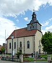
Catholic Church of St. Urban | The Catholic Church of St. Urban was built from 1741 to 1744 on the site of another church. The interior is in the baroque style, the altar from 1721 is a gift from the Reifenstein monastery. The pulpit was created by Johann Peetz in 1756. |
|
|
| Werxhäuser Strasse 52 51 ° 30 ′ 58 ″ N, 10 ° 11 ′ 11 ″ E |
Residential building |
Westerode
| location | designation | description |
ID |
image |
|---|---|---|---|---|
| At the train station 51 ° 31 ′ 21 ″ N, 10 ° 13 ′ 28 ″ E |
Station building | 35203094 | ||
| Westeröder Strasse 10 51 ° 31 ′ 11 ″ N, 10 ° 13 ′ 49 ″ E |
Residential building | 35203180 | ||
| Westeröder Strasse 32 51 ° 31 ′ 13 ″ N, 10 ° 13 ′ 36 ″ E |
church | The Protestant church was built in the neo-Gothic style in 1901. | 35203220 |

|
| Westeröder Strasse 24 51 ° 31 ′ 13 ″ N, 10 ° 13 ′ 40 ″ E |
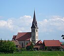
Catholic Church of St. John Baptist | The previous building was demolished in 1899. The church was built in the neo-Gothic style. The interior is from the construction period. | 35203200 |
|
literature
- Monument topography Federal Republic of Germany, architectural monuments in Lower Saxony, district Göttingen, part 2, volume 5.3, 1997, edited by Peter Ferdinand Lufen, published by Christiane Segers-Glocke, Verlag CW Niemeyer Buchverlage , Hameln, ISBN 3-8271-8257-3

