List of architectural monuments in equals
In the list of architectural monuments in Gleichen , listed buildings of the Lower Saxony municipality of Gleichen ( district of Göttingen ) are listed. The list is as of 1997.
General
The community of Gleichen has existed since January 1, 1973. The monuments are located in the districts of Beienrode , Benniehausen , Bischhausen , Bremke , Diemarden , Gelliehausen , Ischenrode , Kerstlingerode , Klein Lengden , Reinhausen , Rittmarshausen , Sattenhausen , Weißenborn and Wöllmarshausen .
The columns contain the following information:
- Location: the address of the monument and the geographical coordinates . Map view to set coordinates . In the map view, monuments without coordinates are shown with a red marker and can be set on the map. Architectural monuments without a picture are marked with a blue marker, architectural monuments with a picture with a green marker.
- Official name: Name of the monument
- Description: the description of the monument. Under § 3 (2) NDSchG individual monuments and under § 3 (3) NDSchG groups of structures and their components are shown.
- ID: the number of the monument
- Image: a picture of the monument
Beienrode
| location | designation | description |
ID |
image |
|---|---|---|---|---|
| Duderstädter Strasse 8 51 ° 28 ′ 1 ″ N, 10 ° 7 ′ 1 ″ E |
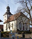
church | The Evangelical Lutheran Church of St. Bartholomäi is in the center of the village on a hill. It was rebuilt in 1732 after the late medieval predecessor building had been destroyed by lightning (panels with Latin building inscriptions and a chronogram). Inside there is an altarpiece that was made in 1603 for the church of Kerstlingerode and transferred to Beienrode in 1733 before it was rebuilt; the predella shows a plaster relief depicting the Last Supper of Jesus; the painted altarpiece was added in the 19th century. The pulpit from 1586 was originally made for Kerstlingerode; in the arcatures the four evangelists are depicted (also as plaster figures). The font is dated 1732. The organ was built in 1735/36 (probably by Johannes Creutzburg from Duderstadt); In the old, somewhat widened case, there has been a new movement by Carl Heyder from Heiligenstadt since 1854, which was renovated and partially changed in 1962/63 by Paul Ott from Göttingen. |
|
|
| Duderstädter Strasse 15 51 ° 27 ′ 57 ″ N, 10 ° 7 ′ 6 ″ E |
Residential building | |||
| L 569 51 ° 28 ′ 7 "N, 10 ° 6 ′ 57" E |
bridge |

|
||
| Zum Klingenberg 2 51 ° 28 ′ 3 ″ N, 10 ° 7 ′ 0 ″ E |
court | The house was built in the second half of the 18th century. The house was expanded around 1900. | ||
| Zum Klingenberg 3 51 ° 28 ′ 1 ″ N, 10 ° 6 ′ 59 ″ E |
court | |||
| Zum Klingenberg 12 51 ° 27 ′ 58 ″ N, 10 ° 6 ′ 57 ″ E |
Residential building |
Benniehausen
| location | designation | description |
ID |
image |
|---|---|---|---|---|
| Oak pitcher 2 51 ° 29 ′ 28 ″ N, 10 ° 1 ′ 50 ″ E |
court | Former hostel house, built in 1574. Half-timbered building with a slight protrusion of the upper floor |

|
|
| Oak pitcher 5 51 ° 29 ′ 24 ″ N, 10 ° 2 ′ 16 ″ E |
Wittmarshof Chapel | The chapel was built in the early 17th century. The sandstone retaining wall is striking, and the chapel is located above this wall. |

|
|
| Gelliehäuser Strasse 1 51 ° 29 ′ 19 ″ N, 10 ° 3 ′ 10 ″ E |
Residential building | |||
| Gelliehäuser Strasse 3 51 ° 29 ′ 17 ″ N, 10 ° 3 ′ 12 ″ E |
Residential building | |||
| Gelliehäuser Strasse 10 51 ° 29 ′ 18 ″ N, 10 ° 3 ′ 9 ″ E |
church | The church was built in 1779–1787. It is a three-axis hall church, the tower of which is made of timber frame in the upper part and ends with a Welschen dome . |

|
|
| Mühlenstrasse 1 51 ° 29 ′ 16 ″ N, 10 ° 3 ′ 10 ″ E |
Residential building | |||
| Mühlenstrasse 14 51 ° 29 ′ 14 ″ N, 10 ° 2 ′ 53 ″ E |
Mill | The mill was probably built in the middle of the 17th century or a little later. It is a two-story half-timbered building. | ||
| Niedeck 5 51 ° 30 ′ 2 ″ N, 10 ° 3 ′ 43 ″ E |
Niedeck Castle | The history of the castle goes back to the 13th century. The castle fell into disrepair in the 17th century. |

|
|
| Niedeck 5 51 ° 29 ′ 55 ″ N, 10 ° 3 ′ 53 ″ E |
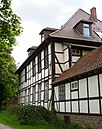
New office building | The office building of what was then the Niedeck office was built in 1751. |
|
|
| Waterloostrasse 2 51 ° 29 ′ 18 ″ N, 10 ° 2 ′ 50 ″ E |
court | |||
| Waterloostrasse 6 51 ° 29 ′ 18 ″ N, 10 ° 2 ′ 56 ″ E |
Residential building | The house was built around 1900. | ||
| Waterloostrasse 7 51 ° 29 ′ 19 ″ N, 10 ° 2 ′ 55 ″ E |
court | |||
| Waterloostrasse 12 51 ° 29 ′ 18 ″ N, 10 ° 3 ′ 0 ″ E |
court |
Bischhausen
| location | designation | description |
ID |
image |
|---|---|---|---|---|
| At the Hagen 7 |
Residential building | |||
| Dammtor 3 |
Residential building | |||
| Dammtor 12 |
Residential building | |||
| Dammtor 15 |
Residential building | |||
| Drosselweg 5 |
Residential building | |||
| Fuchsloch 8 51 ° 26 ′ 45 ″ N, 10 ° 4 ′ 48 ″ E |
Residential building | |||
| Hirtenbergstor 51 ° 26 ′ 49 ″ N, 10 ° 4 ′ 58 ″ E |
church | The Protestant Church of St. Martini is exposed on a hill in the center of the village. In 1739 it replaced a previous medieval building. The hall building contains a late Gothic winged altar with a carved altar shrine and painted outer wings from the period around 1500, which was integrated into the baroque pulpit altar wall of the new church, but is now again set up free-standing on a stone altar block. |

|
|
| Obertor 6 |
Residential building | |||
| Schmiedestraße 1 |
Residential building | |||
| Schmiedestraße 3 |
Residential building | |||
| Teufelstor 4 |
Residential building | |||
| Teufelstor 6 |
Residential building |
Bremke
| location | designation | description |
ID |
image |
|---|---|---|---|---|
| 51 ° 28 ′ 13 ″ N, 10 ° 2 ′ 24 ″ E | Neuengleichen Castle | On each mountain of the mountain couple Die Gleichen there was a castle. On the southern mountain stood Altenleichen Castle, on the northern mountain the Neuengleichen Castle. The castles were built around 1100 by the Counts of Reinhausen. From the middle of the 16th century, the castles then fell apart. There are only a few remains of Neuengleichen Castle. |

|
|
| bridge | ||||
| Appenrode 51 ° 27 ′ 38 ″ N, 10 ° 2 ′ 14 ″ E |
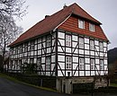
Good Appenrode |
|
||
|
Elbickerode 51 ° 26 ′ 2 ″ N, 10 ° 3 ′ 43 ″ E |
Elbickerode Manor |

|
||
| Reel 7 51 ° 27 ′ 0 ″ N, 10 ° 2 ′ 28 ″ E |
Residential building | |||
| Heiligenstädter Strasse 51 ° 26 ′ 57 ″ N, 10 ° 2 ′ 28 ″ E |
church | The Evangelical Lutheran Church of St. Matthias shows Gothic building remains in the quarry stone masonry and, as evidenced by an inscription, was structurally changed in 1772. An altarpiece from around 1770 is part of the interior. |

|
|
| Heiligenstädter Strasse 4 51 ° 27 ′ 3 ″ N, 10 ° 2 ′ 10 ″ E |
Residential building | Today there is a restaurant here. |

|
|
| Heiligenstädter Straße 6 |
Residential building | |||
| Heiligenstädter Straße 25, 33 |
Residential building | |||
| Heiligenstädter Straße 34 |
Residential building | |||
| Heiligenstädter Straße 40, 43 |
Residential building | |||
| Heiligenstädter Straße 45 |
Residential building |
|
||
| Heiligenstädter Straße 48 |
Göpel |

|
||
| Heiligenstädter Straße 50-54 |
Residential houses | |||
| Heiligenstädter Straße 53, 59, 78 |
Residential building | |||
| 51 ° 27 '11 "N, 10 ° 2' 55" E | Jewish cemetery on Eschenberg | Established in 1844 after the older cemetery within the village was full. The tombstones were cleared away in 1944 after the cemetery had been transferred to private property for agricultural use and - if they were preserved - initially neatly laid down after the war and then put up again later. |

|
|
| L 568 |
Mileage pillar | Mileage pillar just before the border with Thuringia, built in 1802, renewed several times |

|
|
| Sennickerode |
Good Sennickerode | Manor house incorporating the fabric of the previous buildings (1778 or 1877–79) built in 1937/38 based on a design by Wilhelm Lossow (Leipzig) |

|
|
| Lower road 20 |
Residential building | |||
| Unterstrasse 22 |
Residential building |
Diemarden
| location | designation | description |
ID |
image |
|---|---|---|---|---|
| Diemarder Warte 51 ° 29 ′ 38 ″ N, 9 ° 58 ′ 8 ″ E |
Landwehr line | The Landwehr line emerged at the beginning of the 15th century. The Diemarder Warte (also: Diemardener Warte) is part of this line. It is a round tower that is left over from the line. |

|
|
| Friedhofsweg 30 51 ° 29 ′ 7 ″ N, 9 ° 58 ′ 18 ″ E |
Cemetery chapel |

|
||
| Göttinger Straße 1 |
court | |||
| Klostergut 1, 2, 3, 4 51 ° 29 ′ 16 ″ N, 9 ° 58 ′ 43 ″ E |
Well | The monastery property was an outer courtyard of the Hilwartshausen monastery . The mansion was built in 1669. | ||
| Reinhäuser Straße 1 |
||||
| Reinhäuser Strasse 24 51 ° 29 ′ 14 ″ N, 9 ° 58 ′ 42 ″ E |
church | The Evangelical Michaeliskirche is located south of the monastery. It is a hall from 1733, the tower in the west of the church probably dates from the Middle Ages. The interior was completed in 1774. The pulpit altar wall in the late classical style was built from 1839 to 1841. The outside of the altarpiece shows images from the life of Mary. The pictures were created in 1520 by the Göttingen painter Heinrich Heisen. In the middle shrine there are carved figures of the twelve apostles, which were made at about the same time and attributed to Bartold Kastrop . |

|
|
| Schwarze Gasse 10 51 ° 29 ′ 8 ″ N, 9 ° 58 ′ 50 ″ E |
House and barn | |||
| 51 ° 29 ′ 12 "N, 9 ° 58 ′ 44" E | Tie |

|
Etzenborn
| location | designation | description |
ID |
image |
|---|---|---|---|---|
| At the Etzenquelle 4 |
Residential building | |||
| Neuendorfer Strasse 51 ° 27 ′ 39 ″ N, 10 ° 9 ′ 48 ″ E |
church | The church was built between 1871 and 1874 according to a design by Conrad Wilhelm Hase (Hanover) in the neo-Gothic style. |

|
|
| Neuendorfer Strasse 6 51 ° 27 ′ 38 ″ N, 10 ° 9 ′ 47 ″ E |
Residential building | |||
| Neuendorfer Strasse 8 51 ° 27 ′ 38 ″ N, 10 ° 9 ′ 48 ″ E |
Residential building | |||
| Neuendorfer Strasse 9 51 ° 27 ′ 40 ″ N, 10 ° 9 ′ 47 ″ E |
Residential building | |||
| Neuendorfer Straße 10 |
Residential building | |||
| Neuendorfer Straße 12 |
Residential building | |||
| Neuendorfer Straße 15 |
Residential building | |||
| Neuendorfer Straße 17 |
Former rectory | The half-timbered house has two floors and a gable roof. The house was built in the middle of the 18th century. |
Gelliehausen
| location | designation | description |
ID |
image |
|---|---|---|---|---|
| Two at the pond |
Residential building | Two-storey half-timbered house under a hipped gable roof, the core from the 2nd half of the 18th century. With a memorial plaque: "Here Gottfried August Bürger wrote a poem in 1773 Lenore " |

|
|
| 6 at the pond |
Residential building | |||
| Appenröder Weg 2 |
Residential building | |||
| Gleichenstraße 2 |
Residential building | |||
| Gleichenstraße 4 |
Residential building | |||
| Gleichenstraße 8 |
Residential building | |||
| Kielstraße 4 |
Rectory | |||
| Pferdegasse 2, 6 |
Residential houses | |||
| Pferdegasse 5 51 ° 28 ′ 36 ″ N, 10 ° 3 ′ 20 ″ E |
Estate | |||
| Pferdegasse 5 51 ° 28 ′ 37 ″ N, 10 ° 3 ′ 22 ″ E |
Church of St. Pankratius | The church is located directly on the estate of the Lords of Uslar-Gleichen. The church was probably built in 1472. Around 1815 the church underwent major changes. Inside there is a sandstone epitaph for Bernhart von Habel, who died in 1582, and an altar painting by Johannes Heisig from 2002. |

|
|
| Weichselgasse 4 |
Residential building | |||
| To Blumental 1 |
Residential building |
Great Lengden
| location | designation | description |
ID |
image |
|---|---|---|---|---|
| 2 at the Kampe |
court | |||
| Göttinger Landstraße 12 |
court | |||
| Greetings Castle | The early to high medieval complex fortified a mountain spur of the Kronenberg with a wall with a double wall and a ditch in front. Due to the lack of settlement remains, a function as a refuge is assumed. | |||
| Mitteldorfstraße 2 |
Rectory | |||
| Mitteldorfstraße 9 |
court | |||
| Niedecker Stieg 5 |
Residential building | |||
| Vorderdorfstraße 5, 6 |
Residential houses | |||
| Vorderdorfstrasse 16 51 ° 30 ′ 34 ″ N, 10 ° 2 ′ 1 ″ E |
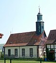
church | The Protestant church was built in the middle of the 18th century. It is a simple, brightly plastered four-axis hall building with a 3/8 end at the choir and an octagonal roof turret over the western gable side. A pulpit altar wall from the beginning of the 19th century and the painting from 1907 determine the interior. |
|
|
| To Lengder Castle 1 |
Residential building | |||
| 6 Lengder Castle |
Residential building | The half-timbered house is one of the oldest buildings in the district. The house was built in the early 18th century and expanded in the 19th century. |
Ischenrode
| location | designation | description |
ID |
image |
|---|---|---|---|---|
| Freienhäger Straße 1 |
court |
|
||
| In the corner 1 |
Residential building |
|
||
| Flap path |
Tie |

|
||
| Flap travel 2 51 ° 25 ′ 49 ″ N, 10 ° 1 ′ 43 ″ E |
church | The Evangelical Lutheran church was built in 1846 and replaced a previous wooden building. The interior is from the construction period. |

|
Kerstlingerode
| location | designation | description |
ID |
image |
|---|---|---|---|---|
| Beienröder Straße 5 |
Residential building | |||
| Bischhäuser Straße 8 |
Residential building | |||
| Pfarrweg 1 |
Residential building | |||
| Pfarrweg 3 |
Residential building | |||
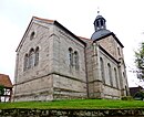
| Pfarrweg 4 51 ° 28 ′ 22 ″ N, 10 ° 6 ′ 24 ″ E |
church | The tower of the church built in 1733. The current nave was built between 1857 and 1858. |
|
|
| Pfarrweg 6 |
Residential building | |||
| Schmiedeweg 3 |
Residential building | |||
| Ziegenmarkt 2 |
Poor house |
Klein Lengden
| location | designation | description |
ID |
image |
|---|---|---|---|---|
| Alte Heerstraße 19 |
Residential building | |||
| Alte Heerstrasse 27 51 ° 29 ′ 46 ″ N, 10 ° 0 ′ 24 ″ E |
church |

|
||
| Alte Heerstraße 30 |
Residential building | |||
| Alte Heerstraße 34 |
Residential building | |||
| In the Dörmke 5 |
Residential building | |||
| In the Dörmke 8/10 |
Residential building | |||
| Im Dörmke 12 51 ° 29 ′ 43 ″ N, 10 ° 0 ′ 19 ″ E |
court | |||
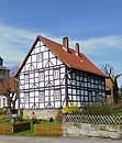
| Ketzhagen 1 51 ° 29 ′ 46 ″ N, 10 ° 0 ′ 26 ″ E |
Rectory | Gabled, two-storey half-timbered house from the second half of the 18th century |
|
|
| L 569 51 ° 29 ′ 33 ″ N, 10 ° 1 ′ 7 ″ E |
spinning | In a previous building there was a grain mill, later a paper mill. The spinning mill was set up in 1847. The spinning mill is a two-story half-timbered house with a gable roof. Next to the spinning mill there is also a residential building and a former bakery. Today there is a museum here. |

|
|
| For Lengder Grund 1 |
court | |||
| 3 for Lengder Grund |
court | |||
| For Lengder Grund 12 |
court |
Reinhausen
| location | designation | description |
ID |
image |
|---|---|---|---|---|
| 7 behind the courtyards |
Residential building | |||
| Behind the courtyards 9 |
Residential building | |||
| 51 ° 27 ′ 9 ″ N, 10 ° 0 ′ 34 ″ E | Hurkutstein | The Hurkutstein is a cave that has been artificially expanded and developed. A hermit lived here in the 14th century. |

|
|
| Kirchberg 51 ° 28 ′ 5 ″ N, 9 ° 59 ′ 2 ″ E |
Former castle | The castle grounds are difficult to see today, as the monastery property was built here later. Finds from the 10th and 11th centuries have been found here during excavations. | ||
| Kirchberg 51 ° 28 ′ 5 ″ N, 9 ° 59 ′ 4 ″ E |
graveyard | The cemetery area covers a large part of the former castle |

|
|
| Kirchberg 5-7 51 ° 28 '8 "N, 9 ° 59' 4" E |
domain | On the site of the old castle or its foreland, a monastery was established and after the monastery was dissolved in the 16th century, the Amtshof of the Reinhausen Office was established. From the buildings of today's domain, in addition to the tenant house, the sandstone barn, the former horse stable and other buildings stand out. |

|
|
| Kirchberg 8 51 ° 28 ′ 4 ″ N, 9 ° 59 ′ 1 ″ E |
Former collegiate church | The Reinhausen monastery church goes back to the former castle church. The changeable building history since the 10th century can be seen in Romanesque, Gothic and Baroque components. Inside there are frescoes and pieces of equipment from the late Gothic period. |

|
|
| Kirchberg 10/12 51 ° 28 ′ 5 ″ N, 9 ° 59 ′ 0 ″ E |
Former convent building | Reinhausen Abbey was founded in 1079 as a canons' monastery. In 1574 the monastery was closed. |

|
|
| L 568 |
bridge |

|
||
| L 568 51 ° 27 ′ 36 ″ N, 10 ° 1 ′ 7 ″ E |
Kurhotel Waldschlösschen | The former Kurhotel Waldschlösschen was built in 1905. It is a three-story half-timbered house with a tent roof. Today the Waldschlösschen Academy , an adult education facility, is located here . |

|
|
| Reinstraße 13 |
Residential building | |||
| Reintalstraße 5 |
Residential building | |||
| Waldstraße |
Bielstein | The Bielstein is a rock spur about 100 meters long made of red sandstone. On the Bielstein there are disc crosses from the Middle Ages. |

|
|
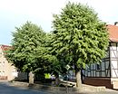
| Waldstrasse 51 ° 28 ′ 3 ″ N, 9 ° 59 ′ 9 ″ E |
Tie |
|
||
| Waldstraße 4 |
Residential building | |||
| Waldstrasse 7 51 ° 28 ′ 10 ″ N, 9 ° 58 ′ 50 ″ E |
Office building | Solid red sandstone building, erected in 1864 |

|
|
| Waldstraße 22 |
Residential building | |||
| Waldstraße 22A |
Residential building | |||
| Waldstraße 29 |
Residential building | |||
| Waldstraße 43 |
Residential building | |||
| Waldstraße 46 |
Residential building | |||
| Ziegelgrund 1 |
Residential building | |||
| Ziegelgrund 3 |
Residential building |
Rittmarshausen
| location | designation | description |
ID |
image |
|---|---|---|---|---|
| At the station 9A |
Residential building | Former station of the Göttingen Kleinbahn |

|
|
| At Rittmarshausen Thie |
Tie |

|
||
| Gartestrasse 51 ° 28 ′ 55 ″ N, 10 ° 6 ′ 13 ″ E |
St. Mary's Church | In 1756–73, the transversely aligned church was built in close proximity to the Tie and the manor. The quarry stone walls were originally plastered, the entrance is in the gabled central projection, the interior is lit through high arched windows. In the middle of the high hipped roof is a roof turret with a high pointed helmet that was attached in the 19th century. Inside there is a pulpit altar from 1775. |

|
|
| At Rittmarshäuser Thie 9 |
Residential building | |||
| At Rittmarshäuser Thie 11 |
Residential building | |||
| Gartestraße 18 |
Residential building | |||
| Gartestraße 20 |
Residential building | |||
| Gartestraße 27 |
Residential building | |||
| Gartestraße 29 |
Residential building | |||
| Gartestraße 30 |
Residential building | |||
| Gartestraße 31 |
Residential building | |||
| Gartestraße 32 |
Residential building | |||
| Gartestraße 16 |
Residential building | |||
| Gartestraße 38 |
Residential building | |||
| Gartestraße 45 |
Residential building | |||
| Gartestraße 47 |
Residential building | |||
| Gartestraße 49 |
Residential building | |||
| Gartestraße 50 |
Residential building | |||
| Gartestraße 51 |
Residential building | |||
| Gartestraße 52 |
Residential building | |||
| Gartestraße 53 |
Residential building | |||
| Gartestraße 54 |
Residential building | |||
| Gartestraße 56 |
Residential building | |||
| Gartestraße 60 |
Residential building | |||
| Gartestraße 64 |
Residential building | |||
| Lindenberg 51 ° 28 ′ 51 ″ N, 10 ° 6 ′ 11 ″ E |
Estate | Manor with a castle-like manor house and farm buildings. Formerly an aristocratic residence fortified by moats, the present mansion built 1703–1716 by Sudfeld Vick (Hanover), including older parts of the building. |

|
|
| Lindenberg 5 |
Residential building |
Sattenhausen
| location | designation | description |
ID |
image |
|---|---|---|---|---|
| Am Ratskeller 1 51 ° 30 ′ 17 ″ N, 10 ° 5 ′ 55 ″ E |
town hall | Former town hall, the oldest half-timbered house in the town, built at the end of the 17th century |

|
|
| Am Ratskeller 2 51 ° 30 ′ 18 ″ N, 10 ° 5 ′ 55 ″ E |
Residential building | Half-timbered house in a courtyard. Multi-storey building with a slight protrusion, probably built at the beginning of the 18th century |

|
|
| Bohlendamm 5 |
Residential building | |||
| Bohlendamm 7 |
Residential building | |||
| Kirchgraben 51 ° 30 ′ 16 ″ N, 10 ° 5 ′ 58 ″ E |
church | The church was built in the late Middle Ages, restored after damage in the Thirty Years War, and expanded to the east in 1695. In the west of the church there is a round defense tower with a diameter of 5.25 meters; Its octagonal, slate-clad top was built in its current form in 1890/91 and renewed around 1950. Some of the interior furnishings date from the late 17th century, some of which were extensively redesigned around 1800 in line with the old building; a new color version was made in the course of a renovation in 1975 ff. |

|
|
| Kirchgraben 3 |
Residential building | |||
| Kirchgraben 4 |
Residential building |

|
||
| Kirchgraben 5 |
Residential building | |||
| Kirchgraben 13 |
Residential building | |||
| Kirchgraben 21 |
court | |||
| Obere Straße 13 |
Residential building | |||
| Upper street 15 |
Residential building | |||
| Obere Straße 18 |
Residential building | |||
| Wennekenstraße 10 |
Residential building |
Weissenborn
| location | designation | description |
ID |
image |
|---|---|---|---|---|
| Am Hopfenberg 1 51 ° 26 ′ 28 ″ N, 10 ° 7 ′ 46 ″ E |
Bleaching Hut | |||
| Eschenweg 7 51 ° 26 ′ 18 ″ N, 10 ° 7 ′ 46 ″ E |
church | The Evangelical Church of St. Nikolai was built in 1738/1739. |

|
|
| In the Lady Valley 6 51 ° 26 '23 "N, 10 ° 7' 31" E |
court | |||
| Hungerborn 1 51 ° 26 ′ 19 ″ N, 10 ° 7 ′ 41 ″ E |
Residential building | |||
| L 569 51 ° 27 ′ 21 "N, 10 ° 8 ′ 19" E |
bridge |

|
||
| Steinweg 1 51 ° 26 ′ 22 ″ N, 10 ° 7 ′ 44 ″ E |
court | |||
| To Gartequelle 1 51 ° 26 '24 "N, 10 ° 7' 36" E |
Tie |

|
Woellmarshausen
| location | designation | description |
ID |
image |
|---|---|---|---|---|
| Gottfried-August-Bürger-Straße 2 |
Residential building | |||
| Gottfried-August-Bürger-Straße 4 |
Dreiseithof | |||
| Gottfried-August-Bürger-Straße 5 |
Watermill | First mentioned in the document dated November 25, 1361, because from this point in time a distinction is made in Wöllmarhausen between Ober- and Untermühle. Before that, only one mill issued certificates, namely the Obermühle. First mentioned in the monastery archive Reinhausen of the mill M CC LV III. | ||
| Gottfried-August-Bürger-Straße 6 |
Residential building | The estate's house was built in 1789. | ||
| Gottfried-August-Bürger-Straße 14 |
Residential building | |||
| Gottfried-August-Bürger-Straße 19 |
Residential building | |||
| Gottfried-August-Bürger-Straße 22 |
Residential building | |||
| Gottfried-August-Bürger-Straße 28 |
Residential building | |||
| Two triangle |
Residential building | |||
| Mühlengasse 1 |
court | |||
| Mühlengasse 5 |
Residential building | |||
| Sattenhäuser Strasse 3 51 ° 29 ′ 17 ″ N, 10 ° 5 ′ 22 ″ E |
church | The church was built in 1756, the tower dates from the Middle Ages. |

|
|
| Sattenhäuser Straße 17 |
Village blacksmiths | |||
| In front of the mountain 2 |
court | |||
| 51 ° 29 ′ 28 "N, 10 ° 4 ′ 26" E | Jewish Cemetery | The cemetery was occupied from 1858 to 1870. There are nine tombstones left here. |

|
literature
- Monument topography Federal Republic of Germany, architectural monuments in Lower Saxony, district Göttingen, part 2, volume 5.3, 1997, edited by Peter Ferdinand Lufen, published by Christiane Segers-Glocke, Verlag CW Niemeyer Buchverlage , Hameln, ISBN 3-8271-8257-3
Individual evidence
Web links
Commons : architectural monuments in equals - collection of images, videos and audio files

