List of listed objects in Bruck an der Mur
The list of listed objects in Bruck an der Mur contains the 63 listed , immovable objects of the Austrian municipality of Bruck an der Mur in the Styrian district of Bruck-Mürzzuschlag .
Monuments
| photo | monument | Location | description | Metadata |
|---|---|---|---|---|

|
Stone Cross ObjectID : 107967 |
Wiener Straße location KG: Berndorf |
The approx. 8 m high wayside shrine in Gothic style dates from the 15th century and marked the border between the district courts of Bruck and Kapfenberg, but also between the lordly magistrates of Bruck and Pischk, which was then administered by the Stubenbergers . It is the first time in a landscaped around 1480 Urbar mentioned Landskron the rule. Placed on a hill, it was still visible from afar in earlier times and also served as a landmark. It has fluted corner pillars on all four sides with pointed arch niches decorated with tracery in the upper area. Originally there were four sandstone statues in these niches which are no longer preserved today. It was a statue of the Madonna with a child, a statue of the Savior from the time it was made, and baroque replicas of St. Rochus and the Mariazeller statue of the Virgin Mary. In the years between 2000 and 2005, the monument was completely restored. |
ObjectID : 107967 Status: § 2a Status of the BDA list: 2020-02-29 Name: Steinkreuz GstNr .: .30 / 6 |

|
Pöglhof (main building) ObjectID : 107946 since 2020 |
Pöglhof 1 KG location : Berndorf |
The manor, built in place of a fortification by the Eppensteiners from the 11th century, was owned by the Pögl hammer mills from 1531 to 1578. A historical reconstruction took place in the second half of the 19th century, including a medieval tower on the southwest corner. |
ObjectID : 107946 Status : Notification Status of the BDA list: 2020-02-29 Name: Pöglhof (main building) GstNr .: 89/5 |

|
Catholic branch church hl. Georg am Pöglhof ObjectID : 35921 |
KG location : Berndorf |
The branch church of St. Georg am Pöglhof was built over a former fortification (owned by the "Lomnicha" family) of the Eppenstein family . The church, consecrated to the patron saint of knights, Saint George, is essentially Romanesque. The church was first mentioned in 1060 as the Markwart von Eppenstein's own church. In 1066 she was granted the privilege of baptism and funeral rights. At the end of the 15th century it was rebuilt in the late Gothic style. The facade is simple and has no structure. The nave is covered with a hipped roof, which is crowned by a hexagonal ridge turret. At the end of the 17th century, a sacristy was added to the north of the choir. The west portal with a shoulder arch, the north portal with a round arch and a pointed arch window in the south and a window with tracery in the east are also worth mentioning.
The star rib vault inside is richly decorated with plant ornaments. The ribs are painted in yellow, green, red and blue. The net rib vault of the choir was decorated around 1500 with tendril motifs, evangelist symbols, a Christ monogram and busts of the four church fathers . Georg Kugelmann's armorial tree was also attached there. The south wall of the nave is divided into image fields, which depict the 14 emergency helpers. Above it, inscriptions tell of events between 1490 and 1511. The altarpiece from 1712 depicts St. George. The saints Franz Xaver and Nepomuk are depicted on the sides. A carving by Anna selbdritt from 1420 to 1430 is also artistically valuable . |
ObjectID : 35921 Status : Notification Status of the BDA list: 2020-02-29 Name: Kath. Filialkirche hl. Georg am Pöglhof GstNr .: .29 |

|
Minorite Monastery ObjectID : 35914 |
Am Grazer Tor 1 location KG: Bruck an der Mur |
ObjectID : 35914 Status : Notification Status of the BDA list: 2020-02-29 Name: Minorite Monastery GstNr .: .126 / 1 |
|

|
Bürgerhaus ObjektID : 35915 |
Am Grazer Tor 2 location KG: Bruck an der Mur |
The core of the community center dates back to the 15th and 16th centuries. Century, the two-storey facade from the end of the 18th century. |
ObjectID : 35915 Status : Notification Status of the BDA list: 2020-02-29 Name: Bürgerhaus GstNr .: .145 / 1 |

|
Maria-Hilf-Chapel ObjectID : 108327 |
Am Schiffertor location KG: Bruck an der Mur |
When exactly the foundation stone of the chapel was laid is unclear. First mentioned in a document in 1783. The late baroque building with volute gable and two- bay groin vault including the altar grille dates from the 18th century and was built onto the outer double city wall. Parts of the inventory were damaged by several fires. The chapel was restored in 1924 with the help of donations from the townspeople, the last renovation measures took place in 1998/1999 (as of 2012). |
ObjectID : 108327 Status: § 2a Status of the BDA list: 2020-02-29 Name: Maria-Hilf-Kapelle GstNr .: .207 / 2 |

|
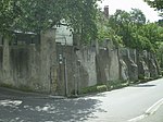
Schifferturm and part of the city fortifications ObjectID : 108378 |
Am Schiffertor 1 location KG: Bruck an der Mur |
Remains of the fortifications of the ship's gate, which was removed in 1888. |
ObjectID : 108378 Status: § 2a Status of the BDA list: 2020-02-29 Name: Schifferturm and part of the city fortifications GstNr .: 78/4 |
|
Parts of the city fortifications ObjectID : 118055 |
Am Schiffertor 3 location KG: Bruck an der Mur |
ObjektID : 118055 Status: § 2a Status of the BDA list: 2020-02-29 Name: Parts of the city fortifications GstNr .: 162; 837; 193/1; .207 / 2; 78/1; .211 |
|

|
Two post milestones and two curbstones ObjectID : 124671 |
Brandstetterstrasse 52–56, ger. No. Location KG: Bruck an der Mur |
ObjectID : 124671 Status: § 2a Status of the BDA list: 2020-02-29 Name: Two post milestones and two curbstones GstNr .: 787/3 |
|

|
Elementary school ObjectID : 109592 |
Dr.-Theodor-Körner-Straße 15 KG location : Bruck an der Mur |
ObjectID : 109592 Status: § 2a Status of the BDA list: 2020-02-29 Name: Volksschule GstNr .: .321 Volksschule Körnerstraße (Bruck an der Mur) |
|
|
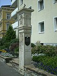
Shrine Object ID: 109619 |
at Dr.-Theodor-Körner-Straße 26 KG location : Bruck an der Mur |
The four-page Renaissance - Tabernakelpfeiler precedes the area of the former Capuchin monastery (in the 19th century abandoned) and was the inscription and coat of arms in 1606 by Mayor Martin Hietwol donated. In the niche of the top there is a statue of the Madonna from the year of the foundation. Below is the coat of arms of the Hitwohl family with its initials HM, the year 1606 and an inscription. |
ObjectID : 109619 Status: § 2a Status of the BDA list: 2020-02-29 Name: Bildstock GstNr .: 113/3 |

|
Residential building ObjektID : 109596 |
Dr.-Theodor-Körner-Straße 30 KG location : Bruck an der Mur |
ObjectID : 109596 Status: § 2a Status of the BDA list: 2020-02-29 Name: Wohnhaus GstNr .: .339 |
|

|
Kindergarten ObjectID : 109601 |
Dr.-Theodor-Körner-Straße 31 KG location : Bruck an der Mur |
ObjectID : 109601 Status: § 2a Status of the BDA list: 2020-02-29 Name: Kindergarten GstNr .: .199; 97/1 Kindergarten Bruck an der Mur |
|

|
Former Citizens Hospital with Martin's Chapel ObjectID : 109606 |
Dr.-Theodor-Körner-Straße 37 KG location : Bruck an der Mur |
The two-story hospital building probably dates from the time the city was founded. It was mentioned for the first time in 1329 as the foundation of Elisabeth, the wife of Duke Friedrich the Fair . Its core was built between the 15th and 16th centuries. In 1331 the Martin chapel was added. The building, still visible today, dates from the 14/15. Century. On the north side it is provided with a late Gothic pointed arch portal and a two-lane window with fish bubble tracery. The fresco of a female saint can be seen next to the portal. The choir has two further two-lane tracery windows. The interior of the nave is covered by a ribbed vault from the second half of the 15th century. The ribbed vault in the chancel (14th century) is closed by a keystone depicting the Lamb of God. The altarpiece of St. Martin is one of the most important late Gothic works in Styria. The original is now in the Joanneum Graz. |
ObjectID : 109606 Status: § 2a Status of the BDA list: 2020-02-29 Name: Former. Bürgerspital with Martinskapelle GstNr .: .229 Martinskapelle in Bruck an der Mur, Austria |

|
Higher Federal Institute for Forestry ObjectID : 109617 since 2012 |
Dr.-Theodor-Körner-Straße 44 KG location : Bruck an der Mur |
ObjectID : 109617 Status : Notification Status of the BDA list: 2020-02-29 Name: Higher Federal Institute for Forestry GstNr .: 416/3 HBLA Bruck an der Mur |
|

|
Former Holy Spirit Chapel ObjectID : 77008 |
Einödstraße 12 KG location : Bruck an der Mur |
Built between 1495 and 1497 in the late Gothic style, the sacred building is characterized above all by its unusual floor plan, which forms an equilateral triangle. The hexagonal interior is covered by a star rib vault. Opened in 1794, the chapel later served as an inn, hay barn and until the 1990s as a residential building. In 2011 an initiative to restore it as a sacred building and memorial was launched. The building was renovated from 2013 to 2018 and largely restored to its original state. |
ObjectID : 77008 Status : Notification Status of the BDA list: 2020-02-29 Name: Former Hl. Geistkapelle GstNr .: .289 Heilig-Geist-Kirche, Bruck an der Mur |
|
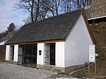
Stucco hut and weapon collection ObjectID : 108371 |
Etzersteig 1 location KG: Bruck an der Mur |
ObjectID : 108371 Status: § 2a Status of the BDA list: 2020-02-29 Name: Stuckhütte and Waffensammlung GstNr .: .25 Stuckhütte in Bruck an der Mur, Austria |
|
|
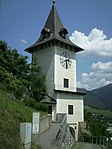
Clock tower, part of the city fortifications ObjectID : 108369 |
Etzersteig 2 location KG: Bruck an der Mur |
Built in 1263 as the gate tower of castrum prukke , which later became Landskron Castle. The passage could be closed by two wooden gates. The building served as accommodation for the town fire watchman since 1792. In 1890/91 the tower was provided with the surrounding balcony and a pointed roof and raised by one floor on behalf of the military captain Rathschüler. The tower has been used as a test transmission station since 1983. |
ObjectID : 108369 Status: § 2a Status of the BDA list: 2020-02-29 Name: Clock tower, part of the city fortifications GstNr .: .416 Clock tower, Bruck an der Mur |

|
House sign St. Florian at the armory of the FF ObjektID : 109620 |
Fraunedergasse 5, 5a KG location : Bruck an der Mur |
ObjectID : 109620 Status: § 2a Status of the BDA list: 2020-02-29 Name: House sign hl. Florian GstNr .: 112/1 |
|
|
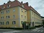
Hahnhof ObjectID : 109623 |
Grabenfeldstrasse 3 KG location : Bruck an der Mur |
Built from 1949 to 1953 under Mayor August Hahn according to plans by the architect Rudolf Giendl . It was the first major municipal housing project in the municipality after World War II. From 2001 to 2004 the building was completely renovated. |
ObjectID : 109623 Status: § 2a Status of the BDA list: 2020-02-29 Name: Hahnhof GstNr .: .1103; .1104; .1105; .1106; .1107; .910; .911; .912; .913; .914; .915; .916; .917; .960; .961; .964; .965; .966 |
|
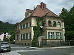
Evang. Parsonage Object ID: 109642 |
Grabenfeldstrasse 4 KG location : Bruck an der Mur |
ObjectID : 109642 Status: § 2a Status of the BDA list: 2020-02-29 Name: Evang. Vicarage GstNr .: .317 |
|

|
Evang. Parish Church AB ObjektID : 56525 |
Grabenfeldstrasse 4 KG location : Bruck an der Mur |
ObjectID : 56525 Status: § 2a Status of the BDA list: 2020-02-29 Name: Evang. Parish church AB GstNr .: .1287 |
|

|
Flößmeisterhaus ObjectID : 35916 |
Herzog-Ernst-Gasse 5 KG location : Bruck an der Mur |
The core of the raft master's house dates from the 2nd quarter of the 16th century (around 1530) and was named after four raft masters who lived in Bruck between 1763 and 1801. It is two-story and four-axis with a chamfered round arch portal with coupled Renaissance windows (south facade) above. The round arch rests on sinuous fluted columns with a richly ornamented rectangular frame and architrave . Two-storey arcades in the inner courtyard, the upper ones were probably renewed after the city fire of 1792. |
ObjectID : 35916 Status : Notification Status of the BDA list: 2020-02-29 Name: Flößmeisterhaus GstNr .: .68 |
|
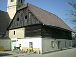
Mesnerhaus ObjektID : 35918 |
Heubergstrasse 1 KG location : Bruck an der Mur |
The sacristan's house stands on the cemetery wall , has two floors and is covered with a crooked roof. The ground floor is bricked, the upper floor was built in log construction. The building probably dates from the 18th century. |
ObjectID : 35918 Status: § 2a Status of the BDA list: 2020-02-29 Name: Mesnerhaus GstNr .: .311 |

|
City parish church Mariae Birth and former cemetery area ObjektID : 56526 |
Kirchplatz location KG: Bruck an der Mur |
Erected around 1270 in the Romanesque style (tower, west gate, choir). Around 1300 the church was expanded to include the Gothic presbytery. The ornate door of the sacristy is a masterpiece of medieval blacksmithing and dates from around 1500. The side altars were erected in 1755, the pulpit and high altar at the beginning of the 19th century. In 1890 the baroque onion dome of the bell tower was replaced by the spire that still exists today. The tower thus reaches a height of 68 m. |
ObjectID : 56526 Status: § 2a Status of the BDA list: 2020-02-29 Name: City parish church Mariae Birth and former cemetery area GstNr .: .59; 826/12 Bruck an der Mur parish church |

|
Rectory with courtyard building and part of the city fortifications ObjectID : 56527 |
Kirchplatz 1 KG location : Bruck an der Mur |
ObjektID : 56527 Status: § 2a Status of the BDA list: 2020-02-29 Name: Rectory with courtyard building and part of the city fortifications GstNr .: 178/1; 178/2 |
|

|
Town hall ObjectID : 108110 |
Koloman-Wallisch-Platz 1 KG location : Bruck an der Mur |
The town hall, which is essentially late Gothic, was rebuilt after the great fire in 1792. It was given a classical facade with pilaster strips by J. Rottmayr and Johann Hueber , and above it a triangular gable. In the courtyard three-sided arcades from around 1530 with square vaults from the end of the 18th century. |
ObjectID : 108110 Status: § 2a Status of the BDA list: 2020-02-29 Name: Rathaus GstNr .: .62 |

|
Apothekerhaus ObjektID : 108107 |
Koloman-Wallisch-Platz 2 KG location : Bruck an der Mur |
The core of the apothecary's house dates from the first half of the 16th century; in the courtyard it is provided with two-storey arcades from around 1520/30. The building was extensively renovated in 2012–2013. |
ObjectID : 108107 Status : Notification Status of the BDA list: 2020-02-29 Name: Apothekerhaus GstNr .: .61 |

|
Antauerhaus ObjectID : 108072 since 2013 |
Koloman-Wallisch-Platz 10 KG location : Bruck an der Mur |
The three-story house from the beginning of the 20th century has a facade with rich secessionist decor. |
ObjectID : 108072 Status : Notification Status of the BDA list: 2020-02-29 Name: Antauerhaus GstNr .: .186 / 1; 62 |

|
Kornmesserhaus ObjectID : 35920 |
Koloman-Wallisch-Platz 22 KG location : Bruck an der Mur |
The late Gothic town house Kornmesserhaus was built between 1495 and 1505. |
ObjectID : 35920 Status : Notification Status of the BDA list: 2020-02-29 Name: Kornmesserhaus GstNr .: .109 / 1 Kornmesserhaus (Bruck an der Mur) |

|
Residential and commercial building, factory building ObjektID : 108113 since 2013 |
Koloman-Wallisch-Platz 23 KG location : Bruck an der Mur |
The factory house dates from the 1st half of the 16th century. Three axes of the facade are preferred, the rounded arcades rest on pillars, the windows are suspected. The arcaded courtyard is late Gothic. |
ObjectID : 108113 Status : Notification Status of the BDA list: 2020-02-29 Name: Residential and commercial building, Fabriziushaus GstNr .: .64 |
|
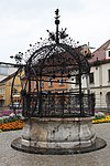
Iron Fountain ObjectID : 108055 |
Koloman-Wallisch-Platz 25, 26 KG location : Bruck an der Mur |
The fountain on the main square is one of the most artistically valuable wrought iron fountains in Styria. According to the inscription, the bulbous stone parapet dates from 1626, the simultaneous fountain arbor is decorated with spindle flowers and wrought iron tendrils and bears the figure of St. Georgs as a sheet metal cut. The surrounding grille on the parapet dates from 1693, the flywheel from 1883. In 1961 the fountain was extensively restored. |
ObjectID : 108055 Status: § 2a Status of the BDA list: 2020-02-29 Name: Eiserner Brunnen GstNr .: 826/3 Eiserner Brunnen (Bruck an der Mur) |

|
Marian column ObjectID : 108057 |
Koloman-Wallisch-Platz 25, 26 KG location : Bruck an der Mur |
The Marian Column (so called) was erected in the center of the main square in 1710 as thanks for surviving plague, fire and flood disasters. It also served as a starting point for pilgrimages. The baroque statue of Maria Immaculata , created by Josef Wolff , stands on a smooth shaft , with the city coat of arms on the base. The statues of the 6 saints Florian , Sebastian , Joseph, Johann Nepomuk , Rochus and Antonius on the right and left of the column come from the Bruck sculptor Ignaz Marxer . After the city fire of 1792, the Marian column had to make way for a fountain and was relocated to the southern part of the square. Renovated in 1796 and restored in 1961, it was finally moved to its current location in 2006. |
ObjectID : 108057 Status: § 2a Status of the BDA list: 2020-02-29 Name: Mariensäule GstNr .: 826/3 Mariensäule, Bruck an der Mur |

|
Shrine Object ID: 107193 |
at Leobner Straße 71, KG location : Bruck an der Mur |
ObjectID : 107193 Status: § 2a Status of the BDA list: 2020-02-29 Name: Bildstock GstNr .: 852/1 Shrine Leobnerstraße, Austria |
|

|
Niche shrine, ObjektID : 107263 |
Lichtensteinstrasse 2 KG location : Bruck an der Mur |
ObjectID : 107263 Status: § 2a Status of the BDA list: 2020-02-29 Name: Niche picture stick GstNr .: 572/3 Shrine Lichtensteinstraße, Bruck an der Mur |
|

|
Minoritenkirche Maria im Walde ObjektID : 56524 |
Minoritenplatz location KG: Bruck an der Mur |
ObjectID : 56524 Status: § 2a Status of the BDA list: 2020-02-29 Name: Minoritenkirche Maria im Walde GstNr .: .88 Minoritenkirche Maria im Walde, Bruck an der Mur, Austria |
|
|
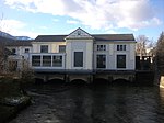
E-Werk Bruck an der Mur ObjectID : 107865 |
Murinsel 2 location KG: Bruck an der Mur |
ObjectID : 107865 Status: § 2a Status of the BDA list: 2020-02-29 Name: E-Werk Bruck an der Mur GstNr .: .377; .378; 452/1 |
|

|
Outdoor swimming pool ObjectID : 107861 |
Murinsel 5 KG location : Bruck an der Mur |
Complex with 30,800 m² of green space and 2,200 m² of water, one of the largest outdoor pools in Upper Styria. |
ObjectID : 107861 Status: § 2a Status of the BDA list: 2020-02-29 Name: Freibad GstNr .: .1515; .1516; .1517; .1518; .1519; .1520; .1521; .1522; .1523; .1525; 452/13 |

|
Pius Institute of the Cross Sisters ObjectID : 107856 |
Piusallee 1 KG location : Bruck an der Mur |
ObjectID : 107856 Status: § 2a Status of the BDA list: 2020-02-29 Name: Pius Institute of the Cross Sisters GstNr .: .309 |
|

|
House Chapel Pius Institute ObjectID : 107857 |
Piusallee 1 KG location : Bruck an der Mur |
ObjectID : 107857 Status: § 2a Status of the BDA list: 2020-02-29 Name: Hauskapelle Pius-Institut GstNr .: .309 |
|

|
Former Staudegger barracks ObjectID : 35922 |
Roseggerstrasse 32 KG location : Bruck an der Mur |
The two-storey, eight-axle building dates from the first half of the 16th century, the simple facade with window frames from the 18th century. Arched Gate. In the courtyard, upper storey arcades on octagonal pillars from around 1530 and basket arch arcades probably from the 18th century. |
ObjectID : 35922 Status : Notification Status of the BDA list: 2020-02-29 Name: Former Staudegger barracks GstNr .: .144 |

|
Cinema, town hall ObjectID : 109586 |
Schillerstraße 1, 3 KG location : Bruck an der Mur |
ObjectID : 109586 Status: § 2a Status of the BDA list: 2020-02-29 Name: Kino, Stadthalle GstNr .: .497 Kulturhaus Bruck an der Mur |
|

|
Reckturm and part of the city fortifications ObjectID : 108376 |
Schillerstraße 7 KG location : Bruck an der Mur |
The - originally semicircular - tower was built in the 13th century. Over the years, it was rebuilt several times and given various uses. In the 16th and 17th centuries it served as a so-called "Reckturm", in which "embarrassing questioning" (torture) was carried out. At the beginning of the 19th century it was converted for residential purposes, it was given a hexagonal upper floor with floor-to-ceiling windows and a balcony in the Biedermeier style . The staircase in the east was added at the end of the 19th century. The tower was inhabited until the 1990s. |
ObjectID : 108376 Status: § 2a Status of the BDA list: 2020-02-29 Name: Reckturm and part of the city fortifications GstNr .: .208; 176; 192/1 Reckturm in Bruck an der Mur, Austria |

|
Landskron Castle Ruins ObjectID : 108372 |
Schloßbergsteig location KG: Bruck an der Mur |
The castle in the south-east of the Schlossberg plateau was mentioned in a document in 1265 as castrum prukke and initially served exclusively for defensive purposes , and more rarely as a royal residence . In 1461 the name Landskron became common. The castle was destroyed in the great city fire in 1792 and had to be demolished for safety reasons. According to a description from 1840, it was neither “large nor magnificent”. The central building was two-story and had a small tower on the west and east side facing the city. The inner wall of the curtain wall was provided with a wooden covered battlement and two rows of loopholes. In 1909 a restaurant was built on the Schlossberg plateau, which burned down in 1979. In 2003, remains of the foundations of the south wall and the east tower were observed. Today nothing remains of the fortress apart from the remains of the curtain wall with its massive supporting pillars, the castle gate and the gate tower, which was later transformed into a clock tower. |
ObjectID : 108372 Status: § 2a Status of the BDA list: 2020-02-29 Name: Burgruine Landskron GstNr .: 211; 212/1; 212/2; 276; 829/2; 829/3 Landskron castle ruins |

|
Catholic branch church hl. Ruprecht bei Bruck ObjectID : 56530 |
St.-Ruprecht-Straße KG location : Bruck an der Mur |
ObjectID : 56530 Status: § 2a Status of the BDA list: 2020-02-29 Name: Kath. Filialkirche hl. Ruprecht bei Bruck GstNr .: .310 Filialkirche hl. Ruprecht (Bruck an der Mur) |
|
|
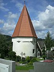
Karner ObjectID : 107161 |
St.-Ruprecht-Straße KG location : Bruck an der Mur |
The Romanesque rotunda, presumably from the 13th century, was originally a church dedicated to St. Chapel consecrated to Erhard. It has a round apse and a domed vault. The octagonal upper floor and the roof are Gothic. The Karner has served as a war memorial chapel since 1931. The windows have been modernized. |
ObjectID : 107161 Status: § 2a Status of the BDA list: 2020-02-29 Name: Karner GstNr .: .429 |

|
Residential building ObjectID : 109597 |
Stadtwerkestrasse 1 KG location : Bruck an der Mur |
ObjectID : 109597 Status: § 2a Status of the BDA list: 2020-02-29 Name: Wohnhaus GstNr .: .1334 |
|

|
Christian Cemetery ObjectID : 107159 |
KG location : Bruck an der Mur |
In the cemetery, which has been expanded several times, there are several remarkable late historical grave structures in neo-Gothic, neo-Renaissance and neoclassical styles from the end of the 19th / beginning of the 20th century: Andrieu, Gava, Till , Malissa, Weydmann. |
ObjectID : 107159 Status: § 2a Status of the BDA list: 2020-02-29 Name: Friedhof christlich GstNr .: 509; 510/2; 512/2 |

|
Calvary ObjectID : 107275 |
KG location : Bruck an der Mur |
ObjectID : 107275 Status: § 2a Status of the BDA list: 2020-02-29 Name: Kalvarienberg GstNr .: .290 / 1; .290 / 2; 768 |
|

|
Calvary Church of the Blood Sweating Savior ObjectID : 56533 |
KG location : Bruck an der Mur |
The Kalvarienbergkirche for the Blood Sweaty Savior is raised south of the city. The baroque hall building has a turret and was donated on the occasion of the plague epidemic in 1716, built in 1718/19 and renovated in 1846. The rectangular nave with the retracted choir is structured by pilasters and surrounding beams. The three-axis facade is loosened up by corner pilasters, pilaster strips and stucco frames. Inside, three- bay groin vault with a retracted triumphal arch, the choir also with groin vault, rectangular windows. Baroque altar fittings and positive organ with painted double doors. |
ObjectID : 56533 Status: § 2a Status of the BDA list: 2020-02-29 Name: Kalvarienbergkirche zum Blutschwitzenden Heiland GstNr .: .292 |

|
Littmann-Till-Gruft ObjectID : 24020 |
KG location : Bruck an der Mur |
ObjectID : 24020 Status : Notification Status of the BDA list: 2020-02-29 Name: Littmann-Till-Gruft GstNr .: 509; 510/2 |
|

|
Catholic branch church hl. Ulrich and former cemetery area ObjectID : 57761 |
Sankt Ulrichstraße 9 KG location : Forest forest |
ObjectID : 57761 Status: § 2a Status of the BDA list: 2020-02-29 Name: Kath. Filialkirche hl. Ulrich and former cemetery area GstNr .: .7; 20/1 branch church hl. Ulrich, Oberaich |
|

|
Paulahof ObjectID : 47932 |
Urgental 1, 2 KG location : Oberdorf-Landskron |
ObjectID : 47932 Status : Notification Status of the BDA list: 2020-02-29 Name: Paulahof GstNr .: .44 / 1; .44 / 3; .44 / 2; .52; 182/1 Paulahof, Oberdorf-Landskron |
|

|
Roman Bridge at St. Dionyses ObjectID : 36461 |
Oberdorf location KG: Oberdorf-Landskron |
ObjektID : 36461 Status : Notification Status of the BDA list: 2020-02-29 Name: Römische Brücke bei St. Dionysen GstNr .: 676/1 Roman bridge, St. Dionysen, Oberaich |
|

|
Rectory with utility wing and walling ObjektID : 119388 |
Sankt Dionysen 3 KG location : Picheldorf |
ObjectID : 119388 Status: § 2a Status of the BDA list: 2020-02-29 Name: Rectory with farm wing and walling GstNr .: .20; 669 St. Dionysen's rectory |
|

|
Kaplanstöckl / Pfarrstöckl ObjectID : 119392 |
near Sankt Dionysen 3 KG location : Picheldorf |
The building, which is covered with a gable roof, is largely made of stone masonry and probably dates back to the 16th century. In 2002, basement rooms were found buried under the building. The Stöckl is located northwest of the rectory . |
ObjectID : 119392 Status: § 2a Status of the BDA list: 2020-02-29 Name: Kaplanstöckl / Pfarrstöckl GstNr .: .20 Pfarrhof St. Dionysen |

|
Catholic parish church hl. Dionysius and Cemetery ObjectID : 119385 |
near Sankt Dionysen 3 KG location : Picheldorf |
Mentioned in a document for the first time in 1152. However, when the foundation stone of the multi-phase church was laid is unknown. Its core is probably still Romanesque (remains of a flat wooden ceiling and arched window), and a baptismal font from around 1200 has also been preserved from the early period. Windows are only on the south side, in the north a covered corridor leads to the rectory. The ceiling of the nave forms a Gothic net rib vault, which is supported by buttresses. The interior of the church was painted with frescoes between the 14th and 15th centuries. They depict saints, prophets, angels and the legend of Dionysius and the Annunciation. Parts of them were exposed again in 1950. The choir, built in Gothic style, dates from the 16th century. In the late 18th century the church was redesigned in Baroque style. The high altar, whose image depicts the martyrdom of St. Dionysius, also dates from this period. The tower probably comes from the second building phase of the church. |
ObjectID : 119385 Status: § 2a Status of the BDA list: 2020-02-29 Name: Catholic parish church hl. Dionysius and Friedhof GstNr .: .21; .22; 673 Parish Church of St. Dionyses |

|
Mortuary Object ID: 124784 |
near Sankt Dionysen 3 KG location : Picheldorf |
ObjektID : 124784 Status: § 2a Status of the BDA list: 2020-02-29 Name: Aufbahrungshalle GstNr .: 671 Aufbahrungshalle St. Dionysen |
|

|
Wegkapelle ObjektID : 124797 |
opposite Sankt Dionysenstrasse 21 KG location : Picheldorf |
ObjectID : 124797 Status: § 2a Status of the BDA list: 2020-02-29 Name: Wegkapelle GstNr .: 678/1 Wegkapelle, St. Dionysen |
|

|
Forest Chapel ObjectID : 124794 |
Location KG: Picheldorf |
ObjectID : 124794 Status: § 2a Status of the BDA list: 2020-02-29 Name: Waldkapelle GstNr .: 665/1 Florianikapelle, St. Dionyen |
|

|
Catholic branch church hl. Nikolaus in Pischk and the former cemetery ObjectID : 57485 |
Nikolausweg location KG: Pischk |
ObjectID : 57485 Status: § 2a Status of the BDA list: 2020-02-29 Name: Kath. Filialkirche hl. Nikolaus in Pischk and former cemetery GstNr .: .25; 35/1 |
|

|
Chapel at Berglhof ObjektID : 48504 |
Nikolausweg 30 KG location : Pischk |
ObjectID : 48504 Status : Notification Status of the BDA list: 2020-02-29 Name: Chapel at Berglhof GstNr .: .22 / 4 |
|

|
Karl Morré Monument ObjectID : 107908 |
Bahnhofstrasse location KG: Wienervorstadt |
ObjectID : 107908 Status: § 2a Status of the BDA list: 2020-02-29 Name: Karl-Morré-Denkmal GstNr .: 26/5 |
Former monuments
| photo | monument | Location | description | Metadata |
|---|---|---|---|---|

|
Weir system Oberaich ObjektID : 119383 until 2019 |
KG location : Oberaich |
Note: The weir system extends over the cadastral communities Oberaich and Oberdorf-Landskron . |
ObjectID : 119383 Status: § 2a Status of the BDA list: 2019-01-23 Name: Oberaich weir system GstNr .: 1154 Oberaich weir system |

|
Defense system Oberaich ObjectID : 107870 until 2019 |
KG location : Oberdorf-Landskron |
Note: The weir system extends over the cadastral communities Oberaich and Oberdorf-Landskron. |
ObjectID : 107870 Status: § 2a Status of the BDA list: 2019-01-23 Name: Wehranlage Oberaich GstNr .: 692; 173/2 Oberaich weir system |
literature
- Kurt Woisetschläger , Peter Krenn : The art monuments of Austria. Dehio-Handbuch Steiermark: (excluding Graz) . Anton Schroll & Co, Vienna, 1982, published by the Federal Monuments Office , ISBN 3-7031-0532-1
- Werner Strahalm: Bruck an der Mur. From the beginning to the present . Edition Strahalm, Graz-Vienna 1987, ISBN 3-900526-05-2 .
Web links
Individual evidence
- ↑ a b Styria - immovable and archaeological monuments under monument protection. (PDF), ( CSV ). Federal Monuments Office , as of February 18, 2020.
- ↑ a b c d e f g Information board on site
- ↑ Werner Strahalm: 1987, pp. 142-143
- ^ Kurt Woisetschläger, Peter Krenn: Die Kunstdenkmäler Österreichs. Dehio-Handbuch Steiermark: (excluding Graz) . Ed .: Federal Monuments Office. Anton Schroll & Co, Vienna 1982, ISBN 3-7031-0532-1 , p. 60 .
- ↑ Werner Strahalm: 1987, pp. 142-143
- ↑ Werner Strahalm: 1987, p. 140
- ↑ Werner Strahalm: 1987, p. 158
- ↑ Werner Strahalm: 1987, p. 141
- ↑ Werner Strahalm: 1987, pp. 133-135
- ↑ Folder: Day of the Monument “History (s) in the Monument”, “Zgodbe kulturne deiscine”, September 30, 2012, BDA Vienna 2012
- ↑ Information board at the parish church of St. Ruprecht
- ↑ Information board on site
- ↑ a b Styria - immovable and archaeological monuments under monument protection. (PDF), ( CSV ). Federal Monuments Office , status: 23 January 2019.
- ↑ § 2a Monument Protection Act in the legal information system of the Republic of Austria .
