
Liwia Łuża
|
Liwia Łuża Eiersberger See |
||
|---|---|---|

|
||
| Geographical location | Treptow Coast , West Pomeranian Voivodeship | |
| Tributaries | Struga Sadlno, Kanał Lądkowski | |
| Drain | Canal Liwia Łuża | |
| Places on the shore | Niechorze , Pogorzelica , Skalno | |
| Data | ||
| Coordinates | 54 ° 5 '18 " N , 15 ° 5' 54" E | |
|
||
| Altitude above sea level | 0.3 m npm | |
| surface | 2.108 km² | |
| length | 2.3 km | |
| width | 1.4 km | |
| volume | 1,983,000 m³ | |
| scope | 6.5 km | |
| Maximum depth | 1.7 m | |
| Middle deep | 0.94 m | |
| Catchment area | 160.7 km² | |
|
particularities |
Strandsee, nature reserve |
|

Liwia Łuża ( German Eiersberger See or Horst-Eiersberger See ) is a beach lake in the Gmina Rewal and thus belongs to the Powiat Gryficki in the Polish West Pomeranian Voivodeship .
description
The Liwia Łuża is located on the Treptow coast in the basin of a former glacial lake . It was created when an earlier bay was separated from the Baltic Sea by a sand wall. Today it is 400 m wide in the west and 1200 m in the east. The lake and the sea are connected by an approximately 1000 m long canal, which is also called Liwia Łuża ( Love Lose ). The lake drains into the Baltic Sea via this channel, but in the case of stormy winds from the north, seawater also flows into the lake, the level of which is only about 30 centimeters above sea level. From the south, the water of numerous ditches from the Cammin-Treptower Bruch flows into the lake via the Kanał Lądkowski . In the southeast the Sadlno brook flows into the Liwia Łuża. The fertilization of the meadows in the catchment area and, until recently, the direct discharge of domestic sewage led to an eutrophication of the Liwia Łuża.
The lake has an area of 2.1 km². Its catchment area is 160.7 km². The 6.5 km long lakeshore is flat and boggy everywhere. The width of the reed belt varies from 5 to 60 m. A progressive siltation can be observed especially on the south bank . The water is a maximum of 1.7 m, but on average only 94 cm deep. The bottom of the lake is boggy. 1.5 km to the east is the Konarzewo ( Kirchhagener See ), another shallow beach lake.
On the dam on the northern shore of the lake are the central part of the village of Niechorze and the west of Pogorzelicas ( fishermen's cottages ). The tracks of the Greifenberger Kleinbahn run near the shore . On the south-east bank is the village of Skalno, which with its German name Eiersberg used to give the lake its name .
natural reserve
In 1959 the lake and a narrow strip of shoreline with a total area of 239.74 hectares were placed under nature protection as "Rezerwat przyrody Jezioro Liwia Łuża". This was intended to protect the breeding populations of the mute swan and the golden-bellied duck. Today's protection goal is broader and consists of preserving the unique ecosystem of rare, especially salt-loving plant species and water birds . The latter include the Haubentaucher , the crane , the Gray Goose , the harrier , the Rotschenkel , the black-headed gull , the white-fronted goose , the Saatgans , the gull , the Cormorant and the tern . The most common types of fish are the bream , the silver bream , the roach and tench . Also represented are the European eel , rudd , pike , three-spined stickleback , perch , ruff , pikeperch , aland , bleak , gudgeon , grass carp , crucian carp , carp , sea trout and the Atlantic Salmon . The otters , grass snakes and various amphibians such as the common toad , the common toad and the fire-bellied toad also live in the area .
The lake is located in the Natura 2000 areas “Wybrzeże Trzebiatowskie” (PLB320010) and “Trzebiatowsko-Kołobrzeski Pas Nadmorski” (PLH320017).
Recreation
A 9.8 km long circular hiking trail and an 8.8 km long cycle path lead around the lake .
gallery
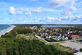
Niechorze between the Baltic Sea (left) and Liwia Łuża (right)
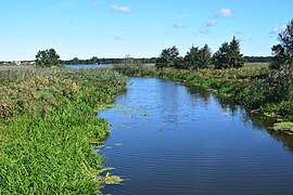
Mouth of the Lądkowski Canal
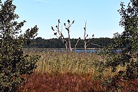
Cormorants on the lake

Sign pointing to the nature reserve

View from the north bank over the lake


Individual evidence
- ↑ a b c d e f g h i Agnieszka Tórz, Jacek Kubiak: Influence of the selected hydrochemical factors upon the nitrogen - phosphorus ratio and factors restraining primary production in coastal lakes: Koprowo, Liwia Łuża and Resko Przymorskie . In: Acta Sci. Pol., Piscaria . Volume 5, No. 2, 2006, pp. 83-98 (English).
- ^ A b Wojciech Zwoliński: Opis do studium uwarunkowań i kierunków zagospodarowania przestrzennego Gminy Rewal . Regionalne Biuro Gospodarki Przestrzennej Województwa Zachodniopomorskiego, Stettin 2005, last update 2013, accessed on October 3, 2019 (Polish).
- ↑ G. Müller: Distribution of the German peat bogs . In: Journal of Practical Geology . 6/1899, pp. 193-206.
- ^ Wilhelm Halbfass: Contributions to the knowledge of the Pomeranian lakes . Justus Perthes, Gotha 1901, p. 121
- ↑ Ordinance on the “Jezioro Liwia Łuża” nature reserve , Regionalna Dyrekcja Ochrony Środowiska, Szczecin August 25, 2017 (Polish), accessed on October 3, 2019 (Polish).
- ↑ Liwia Łuża in the encyclopedia of the publishing house Wydawnictwo Naukowe PWN , accessed on October 3, 2019 (Polish).
- ↑ a b Rezerwat Liwia Łuża on niechorze.pl, accessed on October 3, 2019 (Polish).
- ↑ Wykaz wód powierzchniowych przeznaczonych do bytowania ryb, skorupiaków i mięczaków oraz umożliwiających migrację ryb (PDF; 127 kB). Regionalny Zarząd Gospodarki Wodnej, Szczecin 2009, accessed on October 3, 2019 (Polish).
- ↑ Datasheet of the Natura 2000 area "Wybrzeże Trzebiatowskie", January 2018, accessed on October 3, 2019 (English).
- ↑ Datasheet of the Natura 2000 area "Trzebiatowsko-Kołobrzeski Pas Nadmorski", February 2017, accessed on October 3, 2019 (English).
- ↑ Sketch of the map of the “Liwia Łuża” circular hiking trail, accessed on October 3, 2019 (Polish).
- ↑ Description of the “Szlak Jeziora Liwia Łuża” cycle path, accessed on October 3, 2019 (Polish).