Lyttelton (New Zealand)
|
Lyttelton Māori: Te whaka raupo |
||
| Geographical location | ||
|
|
||
| Coordinates | 43 ° 36 ′ S , 172 ° 43 ′ E | |
| Region ISO | NZ-CAN | |
| Country |
|
|
| region | Canterbury | |
| District | Christchurch City | |
| Ward | Banks Peninsula Ward | |
| Local foundation | 1880 | |
| Residents | 2 859 (2013) | |
| height | Height of sea level | |
| Post Code | 8082 | |
| Telephone code | +64 (0) 3 | |
| UN / LOCODE | NZ LYT | |
| website | www.lyttelton.net.nz | |
| Photography of the place | ||
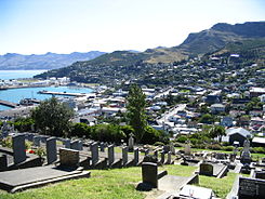
 View over Lyttelton |
||
Lyttelton ( Māori Te whaka raupo ) is a small port town in the urban area of Christchurch City on the South Island of New Zealand .
Origin of name
In the founding period usually Port Cooper or Port Victoria called, the city was officially in 1858 in honor of George Lyttelton, 4th Baron Lyttelton , who at that time an important personality of the Canterbury Association , was in Lyttelton renamed.
geography
Lyttelton is located 10 km south-east of the center of Christchurch , on the north shore of Lyttelton Harbor in the caldera of an ancient volcano, which the Banks Peninsula and between Christchurch and Lyttelton lying Port Hills formed. The city is encircled from west to east by the steep slopes of the former caldera, which marks the highest point of the Port Hills at 499 m northwest of Lyttelton . The harbor is open to the south. a. serves as a seaport for the city of Christchurch . The access to the Pacific Ocean east of the city is around 8 km from the port.
To the southwest of Lyttelton there is an uninhabited island called Quail Island in Lyttelton Harbor and a few other smaller settlements besides the city, of which Governors Bay and Diamond Harbor are the best known.
geology
About 500,000 years ago there was an active volcano in the area of today's Lyttelton , which formed the caldera of today's Lyttelton Harbor . Years ago, about 15,000 was due to the rising sea level sea water to penetrate into the deeper parts of the crater, due to which the present Lyttelton Harbor was that from which Pegasus Bay km to the north 18 in southwestern direction expands.
history
The area around today's Lyttelton is said to have been inhabited by Māori as early as 1000 years ago . They called the place Te whaka raupo , which means something like "port of rushes / reeds ". The area was first sighted by Europeans on February 16, 1770, when the Endeavor sailed the coast under the seafarer and explorer James Cook . The Lyttelton Harbor itself was presumably navigated by the captain S. Chase on his Pegasus in 1809. The whaler Antarctic followed in 1830 and a little later the establishment of whaling stations in the bay.
In 1849 the previously founded Lyttelton was declared a port city. In the following years, the place experienced a heyday when the Canterbury Association , founded in 1848 , which wanted to establish a colony on the South Island with the support of the Church of England , declared the newly developing port city to be their landing point. This decision for Lyttelton was made because of its favorable location, as the place was protected on the one hand, but there was plenty of space for agriculture in the hinterland.
The Lyttelton Times was founded in Lyttelton in 1850 , moved to Christchurch in 1863 and renamed the Christchurch Times on August 1, 1929 and discontinued forever in 1935.
On September 12, 1867, New Zealand's first rail tunnel was opened, connecting Lyttelton with the then up-and-coming Christchurch .
Events
- 1901 - Lyttelton was the starting point of the Discovery Expedition (1901-1904) under Robert Falcon Scott and the Nimrod Expedition (1907-1909) under the direction of Ernest Shackleton , two British research and discovery trips to the Antarctic .
- 1996 - Most outdoor scenes for the horror film The Frighteners from Peter Jackson from 1996 were in Lyttelton rotated.
- 2010 - On September 4, 2010, the Darfield earthquake already caused minor damage in Lyttelton .
- 2011 - On February 22, 2011, as led Christchurch -Erdbeben known earthquakes have become significant damage, landslides and blocked roads in Lyttelton .
population
In the 2013 census, the town had 2,859 inhabitants, 6.9% less than in the 2006 census.
Timeball Station
In 1876 a time ball station was built above the harbor . The equipment on the castle-like building was supplied by the German company Siemens . Formerly essential for setting the time for seafarers, it served its original purpose until 1934, until 1941 it was still used for flag signals . An extensive restoration was undertaken in the 1970s, as a result of which the station was opened to visitors in 1978 and in 1983 was classified as Category 1 ( Sites of Special or Outstanding Historical or Cultural Significance ) by the New Zealand Historic Places Trust . In 2010 the station was one of around 60 still in existence worldwide, only one in five in working order and the only one remaining in New Zealand.
After the Darfield earthquake on September 4, 2010 had already caused minor damage to the station, it was so badly destroyed in the Christchurch earthquake on February 22, 2011 that the ruins had to be removed for safety reasons. Since then, the building has been considered a " Lost Heritage ".
Attractions
In Lyttelton is not only the oldest railway tunnel in the country, but also the longest road tunnel in New Zealand, which since 1964 the extremely steep section on the Port Hills of Christchurch replaced as the most important road link.
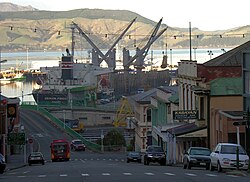
Well-known sights of the city are the port facilities and formerly the Holy Trinity Church . The oldest church building in the region, which was built using stone blocks from nearby Quail Island , was demolished after the 2011 earthquake.
Namesake
The town of Lyttelton is named after the Antarctic Cape Lyttelton .
See also
literature
- Helga Neubauer: Lyttelton . In: The New Zealand Book . 1st edition. NZ Visitor Publications , Nelson 2003, ISBN 1-877339-00-8 , pp. 740-743 .
Web links
- Homepage . Project Lyttelton Inc.,accessed on August 3, 2017(English, website ofCommunity Project Lyttelton).
Individual evidence
- ↑ a b 2013 Census QuickStats about a place: Lyttelton . Statistics New Zealand , accessed August 3, 2017 .
- ↑ a b Topo250 maps . Land Information New Zealand , accessed August 3, 2017 .
- ^ Neubauer: Lyttelton . In: The New Zealand Book . 2003, p. 742 .
- ^ Neubauer: Lyttelton . In: The New Zealand Book . 2003, p. 743 .
- ↑ Lyttelton Timeball Station . Heritage New Zealand , accessed August 3, 2017 .
- ↑ Lost heritage Christchurch City QZ . Heritage New Zealand , accessed August 3, 2017 .
- ↑ http://www.stuff.co.nz/the-press/news/hills-and-harbour/8733640/Little-wooden-church-going-home Little wooden church going home


