
Charleroi light rail
|
|
|
|---|---|
 |
|
| Basic information | |
| Country | Belgium |
| city | Charleroi |
| opening | 1881 (steam tram) 1904 (electric tram) 1976 ( opening of the city railway) |
| operator | TEC |
| Infrastructure | |
| Route length | 33.4 km |
| Gauge | 1000 mm ( meter gauge ) |
| Power system | 600 V = overhead line |
| Stops | 30th |
| Tunnel stations | 12 |
| Depots | 2 |
| business | |
| Lines | 4th |
| Line length | 25.6 km |
| vehicles | 49 (of which 37 in action, 7 in reserve and 5 in reconstruction) |
| Top speed | 65 km / h |
| statistics | |
| Passengers | 3.2 million / year (2007) |
| Mileage | 950,000 km (2010) |
 |
|
The Charleroi light rail ( French : Métro léger de Charleroi) opens up the greater Charleroi area in the Province of Hainaut (Hainaut Province ) in the Walloon part of Belgium . The network stretches over 33 kilometers and has 12 underground stations. The operator is TEC Charleroi, a subsidiary of Transport en Commun (TEC).
prehistory
Eastern network


The first horse-drawn tram line was opened in Charleroi in 1881, it ran from the Südbahnhof through the lower town. In the same year, a standard-gauge steam tram line went into operation from the lower town through the upper town to what is now the Gilly district, and the following year a second followed to Montignies-sur-Sambre . In 1903 the steam-operated routes were taken over by the Société Anonyme des Railways Economiques Liège-Seraing & Extensions (RELSE). Their newly founded subsidiary Tramways Électriques du Pays de Charleroi (TEPCE) switched the routes to meter gauge and electrified the network by 1939. The development meant that it was located in the eastern half of the city region, while the western part was dominated by the national Société nationale des chemins de fer vicinaux (SNCV).
In the framework of efforts, the public transport (public transport) to promote in the metropolitan areas, joined in 1962 the state's municipal transport authority Société des Transports Intercommunaux de Charleroi (STIC) in place of the TEPCE. In 1969 their network, which still consisted of ten lines, extended to Fleurus , Châtelineau , Châtelet and Loverval . The city center of Charlerois was crossed centrally, the route from Gilly to Châtelineau station was driven together with the SNCV.
The trams, known as “Tram vert” (green tram) because of their paintwork, last operated on June 30, 1973, when the remaining routes to Gilly / Fleurus and Montignies / Châtelineau were closed. As part of the reorganization of public transport in Belgium in 1991, the STIC - which until then only operated bus services - became the owner of the newly created metro lines.
Western network


From June 3, 1887, meter-gauge steam-powered overland trams of the SNCV connected Charleroi with Mont-sur-Marchienne , Montigny-le-Tilleul and Lodelinsart . With the exception of the line to Thuillies , all lines were electrified in 1901. In 1929 the network was connected with those of the Borinage (region around Mons ) and the Center (around La Louvière ), with the 40-kilometer line 90 from Charleroi to Mons being created. The new network extended over 122 kilometers from Namur to the French city of Valenciennes .
From 1949 to 1956, the electrified network was extended again and two lines were added. Line 76 created a connection between Charleroi and Namur without changing trains, which was discontinued in 1959. A first wave of decommissioning in 1967/68 fell victim to all the routes south of the Sambre River and east of the Charleroi – Gosselies axis . In 1982, a 132-kilometer overland network was operated with the corner points Charleroi, Thuin , Binche , La Louvière, Maurage and Gosselies.
Line 92 ran from the Eden loop in Charleroi via Anderlues to Thuin until the end of May 1983 ; line 91 then shuttled from Anderlues to Thuin by the end of that year. Museum vehicles from the Thuin Tram Museum now operate on the end section between Lobbes and Thuin .
history
Starting position
In the 1960s, the Charleroi area, known as the “Pays Noir” (Black Land), the oldest mining district on the European mainland, was opened up by two different tram operators . In the west of the city center by the overland network of the SNCV, in the east by the lines of the STIC. Both networks were no longer up-to-date: the rolling stock was out of date and the routes were mostly unfavorably laid out in a single-track position.
At that time, public transport still accounted for 25% of all trips. For the future, a stagnating number of passengers was expected with increasing traffic volume. It was hoped to counteract this through improved local public transport. Another goal was the economic revival in times of the decline of the coal and steel industry - in 1984 the last colliery was shut down - as well as making the city center more attractive.
Decision to build the metro


The plans for a modern railway go back to an initiative of the Belgian government in 1962. By adapting the existing rail traffic, a subway- like network completely independent of road traffic was to be created, with ramps of up to 6% longitudinal incline and minimum curve radii of 70 meters. Modern vehicles should offer sufficient capacity, but the tram networks of STIC and SNCV offered good conditions for the immediate use of the infrastructure to be created by existing vehicles.
The hilly topography required a large number of bridges and tunnels. The use of disused railway lines in the region, which is characterized by collieries, has proven to be cost-effective, but this often means that an unfavorable location of the stops away from the settlement centers is accepted. In the mid-1960s, the planning included an inner city ring and eight branches to the outskirts, which should include 69 stations with a 52-kilometer route. Full commissioning was scheduled for 1994.
Construction of the metro lines began at the end of the 1960s, and the first 800-meter-long section via Villette station to Sud station was put into operation in 1976. South of the later Ouest station, the railways changed from the street to the new route. In 1980 this was extended from Villette via Ouest to the Piges station, and an elevated track triangle was laid between the last two stations . In 1983, the junction west of Piges to the enclosed Dampremy station went into operation, with a waste dump being crossed in the tunnel . At the same time, a first underground station was opened west of the Gleisdreieck with Beaux Arts. Behind this, a turning loop running in the tunnel allowed the turning of those trains that had previously used the loop at the abandoned aboveground end point Eden. In 1996, with a route length of 17 kilometers, a third of the planned network was structurally completed, including the route to Centenaire, which has not yet been opened.
With the commissioning of new lines, most of the tram lines running parallel to them were shut down.
Crisis in the 1980s


The metro project was counteracted by the ever faster decommissioning of the SNCV lines in the 1980s. As a result, the newly created metro infrastructure was used by fewer and fewer lines. In 1988 only lines 89 (Beaux Arts-Anderlues) and 90 (Sud-Anderlues-La Louvière) were in operation.
In addition, the underfunding of the operation and the dispute over competencies between SNCV (operator) and STIC - the owner of the new routes feared the exodus of his bus passengers - had a negative impact. This led to the amazing fact that completely completed routes did not open for years. Also on the shell located stretches of the construction work was set. The operationally unfavorable location of the new routes, the moderate frequency and the neglected appearance of the facilities and vehicles caused the number of passengers to shrink.
Todays situation
As a result of the regionalization of the state of Belgium, responsibility for public transport was transferred to the regions. In Wallonia , the new holding company Société Régionale Wallone du Transport (SRWT) took over local public transport and passed the management on to its subsidiary Transport en Commun (TEC) Charleroi. Since July 1, 1991, the disadvantageous side by side of SNCV and STIC is history, tram and bus traffic can be coordinated from a single source for the benefit of passengers.
In 1992 existing gaps in the light rail line to Fontaine-l'Évêque (Pétria station) were closed and - seven years after its completion - the line to Gilly (including the Waterloo junction) opened. The waterloo – Centenaire line, which is ready for operation, has not yet been put into operation and is increasingly falling into disrepair.
The following routes went into operation on February 27, 2012:
- Completion of the inner city ring with a new Parc – Sud line ( Charleroi-Sud station ). This was not built as an elevated railway , as originally planned , but as a tram.
- The Gilly – Soleilmont stretch of the route, which was completed for a long time in the shell, with the inconveniently located Sart Culpart station being moved closer to the development.
With a slight delay, the line to Gosselies went into operation on June 22, 2013 as line M3. In terms of trams, it largely follows the former tram route and a disused railway line.
Future development
It is not to be expected that the original metro planning will be fully resumed.
Infrastructure


stretch
The following routes were operated in 2018:
- Inner city ring, 8 stations
- Line to Pétria, 11 stations: This line was the first of the originally planned metro lines to be fully completed and put into operation. The extension to Anderlues as a tram on the former SNCV route was not in operation in 2018 due to construction work.
- Line to Soleilmont, 6 stations: Since 2012, this is the second line that has reached the final state of development and is operated in regular service. Previously, it had been in operation from 1985 to Gilly. This route is operated in left-hand traffic , with an intersection of the two direction tracks just before the Samaritaine station (seen out of town).
- Line to Gosselies, 15 stations: This line previously served as an operating line to the Jumet depot and was opened to passenger traffic on June 22, 2013 after four years of renovation work. In the original metro planning, it was planned to completely rebuild this route as a metro on its own route, partly in tunnels. It should branch off from the inner city ring at the Waterloo station - the mouth of the tunnel there has been completed since the early 1990s. Instead, the route was completely renewed as a tram with a special track body .
The development of the track infrastructure is illustrated in the following plans:

City ring west to start operations in 1980

West branch 1982

West connections and Beaux-Arts station to start operations in 1983

Planning to operate the east branches from Waterloo 1985
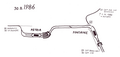
Light rail section Fontaine – Petria on the west branch 1986

Central area 1992
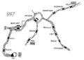
Central area 1997

East branch to Soleilmont 2012


Opening dates

| year | Branch after | route | Number of new train stations |
|---|---|---|---|
| 1976 | Inner city ring | Sud - Ouest | 3 |
| 1980 | Anderlues | Ouest - Piges | 1 |
| 1982 | Anderlues | Moulin - Paradis | 3 |
| 1983 | Inner city ring | Ouest / Piges - Beaux-Arts | 1 |
| 1983 | Anderlues | Piges - Providence | 1 |
| 1986 | Anderlues | Paradis - Pétria | 2 |
| 1992 | Anderlues | Providence - Moulin | 3 |
| 1992 | Inner city ring | Beaux-Arts - Waterloo | 1 |
| 1992 | Soleilmont | Waterloo - Gilly | 3 |
| 1996 | Inner city ring | Waterloo - Parc | 2 |
| 2012 | Inner city ring | Sud - Parc | 1 |
| 2012 | Soleilmont | Gilly - Soleilmont | 3 |
| 2013 | Gosselies | Piges - Gosselies | 15th |
Line network until February 2012
The network was used by the following lines until February 26, 2012:
| line | route | Network plan until February 26, 2012 |
|---|---|---|
| 54 | Sud ← → Waterloo ← → Gilly |

|
| 55 | Parc ← → Waterloo ← → Gilly | |
| Fontaine ← → Gilly ( dashed line , only in high season) | ||
| 88 | Parc ← → Waterloo ← → Beaux-Arts ← → Anderlues | |
| 89 | Sud ← → Beaux-Arts ← → Anderlues |
Line reform 2012


The completion of the inner city ring and the simultaneous extension of the route from Gilly to Soleilmont on February 27, 2012 were used for a far-reaching line reform that also included the future route to Gosselies. With that the last traditional tram line numbers disappeared. The lines have been renumbered from M1 to M4 and color codes have been assigned, which can be found on timetables and route network maps.
All lines have the inner city ring as their destination and only pass through it in one direction. The following table lists the stops at which the lines meet or leave the inner city ring:
| line | Identification color | route | Installation | Remarks |
|---|---|---|---|---|
| M1 | red | Anderlues → Ouest → Stadtring counterclockwise → Beaux-Arts → Anderlues | February 27, 2012 | replaces the previous lines 88 and 89. |
| M2 | green | (Anderlues →) Pétria → Beaux-Arts → City ring clockwise → Beaux-Arts → Pétria (→ Anderlues) | February 27, 2012 | In order to achieve an even service of the inner city ring in both directions, all trips of the line M2 from Pétria to Anderlues were extended in a transitional period (until the opening of line M3). In return, the M1 line ran correspondingly less frequently. |
| M3 | yellow | Gosselies → Beaux-Arts → City ring clockwise → Beaux-Arts → Gosselies | June 22, 2013 | From September 3, 2012 to June 21, 2013, preliminary operation only on the city ring from / to Beaux-Arts from Piges as a tram on a special track |
| M4 | blue | Soleilmont → Waterloo → City ring counterclockwise → Waterloo → Soleilmont | February 27, 2012 | replaces the previous lines 54 and 55, extended from Gilly to Soleilmont. |
The “phantom line” to Centenaire


The planned route to Châtelet on the section Waterloo – Centenaire with the four stations Neuville, Chet, Pensée and Centenaire was completely completed in 1987, but has not been operated in regular traffic since then. The tracks and overhead lines are in working order, and new drivers have been trained on the Waterloo – Chet section for some time. Two further stations (Champeau and Corbeau) are in the shell. As on the branch to Soleilmont, the directional tracks cross shortly after the separation from the inner city ring, so that the route is used in left-hand traffic.
This route could also benefit from the new interest in the expansion plans for the metro that had been idle for years. Their future was discussed in the Walloon Parliament on June 28, 2011 and it was decided to prepare a feasibility study by the end of 2012. There is particular interest, among other things, because the new Cora shopping center in Châtelineau could be opened up with the Corbeau train station.
According to the statements of the TEC, investments of an estimated 15 million euros are necessary to establish an operational condition for the completed route section. The cost of completing the shell section up to Corbeau is estimated at a further 24 million euros. In addition, around 12.5 million euros would be required for additional vehicles, which leads to an approximate total cost of 51.5 million euros - without the operating costs that then arise. A continuation of the route around the two originally planned stations Trieux and Châtelet along the once planned route was not an option in 2012.
On April 25, 2016, the Charleroi City Council voted as a new option to extend the route to the future central hospital in Gilly. For the first time, an extension to Châtelet came into play, but with a new route.
In April 2017, the annual costs of keeping the infrastructure up and running were given as around € 180,000. These costs cannot be avoided because the inner city ring is supplied with electricity over this route. Three variants are now being examined:
- Refurbishment of the route to Centenaire and final expansion of the pre-fabricated route to Corbeau to connect the Cora shopping center, after which the stop would then be named (estimated 2.8 million euros annual operating costs plus the costs already mentioned above)
- Preparation of the line to Centenaire and extension to the new hospital
- Final shutdown of the entire route and demolition of the decaying facilities
The result of this study has been awaited since then. After that, a final decision about the future of the route should be made. However, even if the outcome is positive, the government does not expect to be able to start work in the immediate future.
Stations

_-_01.jpg)
| Tunnel stations | |||
|---|---|---|---|
| Surname | opening | route | Remarks |
| Beaux Arts | May 24, 1983 | Inner city ring | M1 and M4 ↺, M2 and M3 stop in both directions |
| Dampremy | May 24, 1983 | Route to Anderlues | Station enclosed above ground |
| De Cartier | 22nd August 1992 | Route to Anderlues | |
| Fontaine | May 25, 1986 | Route to Anderlues | |
| Gazomètre | August 28, 1992 | Route to Soleilmont | |
| Gilly | August 28, 1992 | Route to Soleilmont | |
| Janson | August 30, 1996 | Inner city ring | M2 and M3 ↻, M1 and M4 ↺ |
| Marabout | February 27, 2012 | Route to Soleilmont | |
| Ouest | June 30, 1980 | Inner city ring | M2 and M3 ↻, M1 and M4 ↺ |
| Parc | August 30, 1996 | Inner city ring | M2 and M3 ↻, M1 and M4 ↺ |
| Samaritaine | August 28, 1992 | Route to Soleilmont | |
| Waterloo | August 28, 1992 | Inner city ring | M2 and M3 ↻, M1 ↺, M4 stops in both directions |
↻: Trains on the line on the inner city
ring only clockwise ↺: Trains on the line only counter-clockwise

| Elevated train stations | |||
|---|---|---|---|
| Surname | opening | route | Remarks |
| Moulin | 22nd August 1992 | Route to Anderlues | |
| Paradis | May 24, 1983 | Route to Anderlues | |
| Piges | June 30, 1980 | Routes to Anderlues and Gosselies | |
| Providence | 22nd August 1992 | Route to Anderlues | |
| Villette | June 21, 1976 | Inner city ring | M2 and M3 ↻, M1 and M4 ↺ |

All other stations are at ground level, with low platforms in the end section Pétria – Anderlues. In Anderlues and Fontaine-l'Évêque (Pétria station) the trains return to the butt tracks behind the station . In Gosselies there are also blunt turns , in Soleilmont a turning loop was created.
The largest station is the underground Beaux Arts station with three tracks on two platforms and a through track. The latter is located on a third platform, not used for passenger operations, on which a historic tram is exhibited on a grooved track embedded in the pavement . Trains in the directions of Anderlues and Gosselies, which traveled clockwise on the ring, initially pass through the station without stopping on the southern through track. You turn around in the subsequent underground loop and come to the stop on the northernmost track of the station. This means that each of these trains is reached a total of three times, with two system stops.
To and from Soleilmont, the trains stop in both directions at the same platform edge of the central platform of the Waterloo station. There is an additional side platform on which there is no track as preliminary construction work. The Soleilmont terminus has two platforms within an end loop, where you can transfer directly to the buses.
The two platforms of the Sud station at Charleroi-Sud station are on the inside of the two legs of the former end loop , which will continue to exist as an intermediate end loop after the completion of the ring. The tracks to and from the Tirou station branch off from this single-track loop. The elevated railway section in the direction of the Villette high station begins to the west of the station, to the right of which there are two sidings .
The terminus Faubourg de Bruxelles on the M3 line in Gosselies has two butt tracks on a central platform, with a parallel siding. To the south of the station, the double-track line splits up to the Carrosse station, with the out-of-town track leading through the narrow Rue de Jumet, the track in the direction of Charleroi being on an abandoned railway line. An operating track just before the terminus, in its function as a clasp between the two directional tracks, if necessary, bypassing the terminus before that one can be turned.
vehicles

In the early days, type S trams operated on the metro routes, which were converted into the SM series (M for metro) for this purpose. Of this, the motor coach 9148, which thanks to folding steps can also approach the elevated platforms, has been preserved. Some of these railcars were modernized again in the 1980s (henceforth the SJ series), of which the 9175 railcar still exists as a work and driving school car. Some other S-wagons are still in use today as construction vehicles, e.g. for overhead line inspections. A few SJ motor coaches are still parked near the main workshop in Jumet as spare parts donors.
Today 44 six-axle articulated railcars of the BN LRV series in a bidirectional design (type 6100 or 7400) are used as passengers. 52 one-way wagons of this series (type 6000) run on the Kusttram , to which surplus wagons from Charleroi were also lent in the main season.
The vehicles were built between 1980 and 1982 by La Brugeoise et Nivelles (BN), car 6103 followed in 1984 with a second crew for the car of the same company number that had an accident in 1981. The meter-gauge railcars with the B'2'B ' wheel arrangement are 22.88 meters long and 2.50 meters wide, their empty weight is 32.5 t. Two 228 kW electric motors accelerate it to a top speed of 65 km / h. In the course of the takeover by the TEC and a modernization in the 2000s, the vehicles previously painted in orange / beige were u. a. a yellow livery with gray and red offset surfaces and new seat covers. Retaining the last two digits, they are now referred to as the 7400 series. The scrolling displays were later replaced by matrix displays . As a rule, the multiple units run individually, while double units are also used on the M4 line during rush hour .
Railcar with the number 6100
Link to the picture
(Please note copyrights )
The BN railcars were procured for the first major expansion stages of the planned network, but in the absence of these, they were also used in the early years on the then still existing tram lines around Charleroi. With the progressive closure of the SNCV lines and the abrupt construction stop in 1985, most of the vehicles soon became de facto redundant, so that numerous railcars were soon simply parked when more complicated damage occurred (due to collisions, etc.) despite their young age. Only when there was an increased demand for vehicles as a result of the few network expansions in the 1990s were a corresponding number of railcars restored and reactivated. The majority of the vehicles that were still parked were reactivated for the network expansions in 2012/2013 at great expense (after more than 20 years of parking time, the railcars were in an increasingly poor condition), so that today only a few cars are parked, including the first railcar with the number 6100.
In the next few years, the vehicles are to receive a comprehensive modernization so that they can still be used in the future. Among other things, the interior pivoting doors are to be replaced by sliding doors running on the outside and the front, the driver's cabs and the passenger compartment are to be redesigned.
The vehicles are in the depots Jumet home and Anderlues. The former is on the route to Gosselies (M3), both are also used for buses. The former tram depots Genson (STIC) and Nalinnes (SNCV) are only used for bus traffic.

Tram (series SM) and light rail vehicles (type 6100) in Anderlues , 1982

1971 railcar (SJ series) in the Sud station, 1982

Work and driving school car 9175, 2016
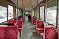
Interior view of a type 7400 car


Remarks
- ↑ According to the numbering scheme of the TEC, all vehicles of the TEC Charleroi have a 7 as the leading number
literature
- Christoph Groneck, Dirk Martin Stein: Metros in Belgium . 1st edition. Robert Schwandl, Berlin 2009, ISBN 978-3-936573-26-8 , pp. 114-137 .
- Helmut Roggenkamp, News from the SNCV in Hainaut / Belgium , Der Stadtverkehr 1/1985, pages 25–29
- R. Jünger, SNCV regional railway in Hainaut near the end? , Stadtverkehr 1/1989, pages 20–23
- Raimund Jünger, Charleroi - The Metro in Sleeping Beauty , Stadtverkehr 4/1989, pages 18–23
- Hans Ahlbrecht, Progress at the Métro léger in Charleroi , Stadtverkehr 1/1992, pages 37–38
- Hans Ahlbrecht, East-West axis of Métro Charleroi opened , Stadtverkehr 1/1993, pages 18–21
- Raimund Jünger, Belgium: Buses replace light rail vehicles to La Louvière , Stadtverkehr 11–12 / 1993, page 52
Web links
- Official website of the TEC Charleroi, in four languages
- Official website of the Metro legér Charleroi, only in French, but more up-to-date
- Tram travel: Transport En Commun en Wallonie (TEC)
- “The Métro Phantôme of Charleroi” - inspection of the route that never went into operation
Individual evidence
- ^ Christoph Groneck, Dirk Martin Stein: Metros in Belgium . 1st edition. Robert Schwandl, Berlin 2009, ISBN 978-3-936573-26-8 , pp. 119 f .
- ^ Christoph Groneck, Dirk Martin Stein: Metros in Belgium , p. 118.
- ↑ Time travel in Belgian in: Straßenbahn Magazin 6/2019, p. 70 ff.
- ^ Christoph Groneck, Dirk Martin Stein: Metros in Belgium , p. 114.
- ↑ a b Christoph Groneck, Dirk Martin Stein: Metros in Belgium , p. 120 f.
- ↑ a b Christoph Groneck, Dirk Martin Stein: Metros in Belgium , p. 122 f.
- ↑ a b c d Christoph Groneck, Dirk Martin Stein: Metros in Belgium , p. 124 f.
- ↑ Information from TEC Charleroi on the line reform of the metro ( Memento of the original from May 20, 2016 in the Internet Archive ) Info: The archive link was inserted automatically and has not yet been checked. Please check the original and archive link according to the instructions and then remove this notice.
- ↑ Information brochure of the TEC Charleroi on the line reform and the line extensions (PDF file; 788 kB)
- ↑ From the 3rd of September 2012, the line de métro M3 (line jaune) dessert la boucle! ( Page no longer available , search in web archives ) Info: The link was automatically marked as defective. Please check the link according to the instructions and then remove this notice. , Communication from TEC-Charleroi, accessed on September 1, 2012
- ↑ Question from MEP Véronique Salvi in the Walloon Parliament on the future of the Charleroi Metro
- ↑ Avis of the Walloon Environment Committee for Sustainable Development (CWEDD) (PDF file; 39 kB)
- ↑ "No funds for the metro". La Libre Belgique, April 21, 2017, accessed October 9, 2017 (French).
- ^ Christoph Groneck, Dirk Martin Stein: Metros in Belgium , p. 115.
- ^ Christoph Groneck, Dirk Martin Stein: Metros in Belgium , p. 126.
- ↑ TEC Charleroi BN 7447 - 6154 & SJ 7874 - 9591. Accessed November 27, 2019 .
- ↑ The Charleroi Metro from Dokumentationszentrum-eisenbahnforschung.org , accessed on November 6, 2018
- ↑ Cure de jouvence pour la flotte du métro léger de Charleroi. October 1, 2018, accessed November 27, 2019 (French).
- ↑ Les dépots at te-commun-charleroi.be, accessed on November 7, 2018