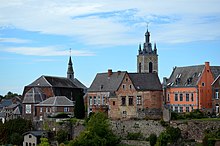
Thuin
| Thuin | ||
|---|---|---|

|

|
|
|
|
||
| State : |
|
|
| Region : | Wallonia | |
| Province : | Hainaut | |
| District : | Thuin | |
| Coordinates : | 50 ° 20 ′ N , 4 ° 17 ′ E | |
| Area : | 76.17 km² | |
| Residents: | 14,702 (Jan. 1, 2019) | |
| Population density: | 193 inhabitants per km² | |
| Post Code: | 6530, 6531, 6532, 6533, 6534, 6536 | |
| Prefix: | 071 | |
| Mayor: | Paul Furlan ( PS ) | |
Local government address : |
Grand Rue, 36 6530 Thuin |
|
| Website: | www.thuin.be | |
Thuin is a municipality in the Belgian province of Hainaut in Wallonia . It is the administrative seat of the Arrondissement of Thuin .
The surrounding landscape, the Thudinie, is named after Thuin .
geography
The city of Thuin is located on a hill above the mouth of the Biesmelle in the Sambre and is divided into an upper and a lower town.
The municipality of Thuin includes the places Biercée, Biesme-sous-Thuin, Donstiennes, Gozée, Leers-et-Fosteau, Ragnies, Thuillies and the city of Thuin.
history
In the area of Thuin, Le Petit Paradis , a Roman cemetery was discovered in 1963 and excavated by the Royal Museum Mariemont . For the first time Thuin was mentioned as Tudinio in a property register of the Lobbes monastery in 866. From 888 until the French Revolution , i.e. 900 years, the place was under the rule of Liège . In 972, Bishop Notger von Liège had the first stone city wall built. In the 12th and 15th centuries, the increase in population required an expansion of the fortifications.
French troops occupied Thuin from 1675 to 1678, but in the Peace of Nijmegen the city returned to the Spanish Netherlands . In 1794, General François Séverin Marceau conquered the city, which, along with the entire region, belonged to the French state from 1795 to 1814 . The Abbey Aulne was up to the foundation walls destroyed.
During the Belgian Revolution , Thuin became part of the Belgian state. During the First World War , like many Belgian cities, the city was affected right at the beginning of the war: As early as August 1914, the opponents were fighting in the Battle of the Sambre : the French 5th Army was surrounded twice by the German troops near Charleroi and suffered heavy losses.
Attractions
- Belfry : The belfry, built in 1639, was originally the steeple of the Saint-Theobard church, which was demolished in 1811 to make room for a seat. The tower counts with other bell towers of Flanders and Wallonia to the World Heritage of UNESCO .
- Tram Museum : The Tram Museum in the lower town on the site of the former Thuin-West small train station shows historic trams of the lines that were in use in the region, especially in Charleroi. From here there are also museum trips to Lobbes .
traffic
Thuin is on the national road 59, which comes from Seneffe and meets the N 53 (Charleroi– Chimay ) at Gozèe .
Thuin has a train station on the Charleroi – Erquelinnes railway line , which was part of the main line between Paris and northern Germany before the Thalys was used.
Town twinning
There is a town partnership with the Italian municipality of Torgnon in the Aosta Valley .
people
- Franck Olivier , pop singer and composer
Web links
Individual evidence
- ↑ Germaine Faider-Feytmans: La nécropole Gallo-romaine de Thuin. Fouilles du Musée du Mariemont II (Brussels 1965).

