
Anderlues
| Anderlues | |||
|---|---|---|---|

|

|
||
|
|||
| State : |
|
||
| Region : | Wallonia | ||
| Province : | Hainaut | ||
| District : | Thuin | ||
| Coordinates : | 50 ° 24 ' N , 4 ° 16' E | ||
| Area : | 17.02 km² | ||
| Residents: | 12,261 (Jan 1, 2019) | ||
| Population density: | 720 inhabitants per km² | ||
| Height: | 170 m | ||
| Post Code: | 6150 | ||
| Prefix: | 071 | ||
| Mayor: | Philippe Tison ( PS ) | ||
Local government address : |
Place Albert 1er, 21 6150 Anderlues |
||
| Website: | www.anderlues.be | ||

Anderlues is a municipality in the Belgian province of Hainaut . It is located around 15 km west of Charleroi between the Maas and Scheldt rivers . The Haine river has its source in the municipality .
Demographic development

Source: Belgian National Institute for Statistics (NIS) - Opm: 1806 t / m 1970 = volkstellingen on December 31; from 1980 = January 1st
traffic
With the M1 and M2 metro lines ending there, the municipality is connected to the Charleroi light rail network . There is a TEC depot next to the Jonction stop .
Parish partnership
Anderlues has a partnership with the French municipality of Gigondas in the Vaucluse department .
Web links

town hall
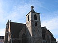
Old Church of St. Médard

Old St. Médard, rear view

.JPG)

Aiseau-Presles | Anderlues | Antoing | Ath | Beaumont | Belœil | Bernissart | Binche | Boussu | Braine-le-Comte | Brugelette | Brunehaut | Celles | Chapelle-lez-Herlaimont | Charleroi | Châtelet | Chièvres | Chimay | Colfontaine | Comines warning sound | Courcelles | Dour | Écaussinnes | Ellezelles | Enghien | Erquelinnes | Estaimpuis | Estinnes | Farciennes | Fleurus | Flobecq | Fontaine-l'Évêque | Frameries | Frasnes-lez-Anvaing | Froidchapelle | Gerpinnes | Ham-sur-Heure-Nalinnes | Hensies | Honnelles | Jurbise | La Louvière | Le Rœulx | Lens | Les Bons Villers | Lessines | Leuze-en-Hainaut | Lobbes | Manage | Merbes-le-Château | Momignies | Mons | Mont-de-l'Enclus | Montigny-le-Tilleul | Morlanwelz | Mouscron | Pecq | Péruwelz | Pont-à-Celles | Quaregnon | Quévy | Quiévrain | Rumes | Saint-Ghislain | Seneffe | Silly | Sivry-Rance | Soignies | Thuin | Tournai