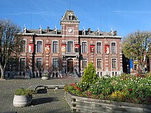
Chapelle-lez-Herlaimont
| Chapelle-lez-Herlaimont | ||
|---|---|---|

|

|
|
|
|
||
| State : |
|
|
| Region : | Wallonia | |
| Province : | Hainaut | |
| District : | Charleroi | |
| Coordinates : | 50 ° 28 ′ N , 4 ° 17 ′ E | |
| Area : | 18.1 km² | |
| Residents: | 14,737 (Jan 1, 2019) | |
| Population density: | 814 inhabitants per km² | |
| Post Code: | 7160 | |
| Prefix: | 064 | |
| Mayor: | Patrick Moriau ( PS ) | |
Local government address : |
Administration Communale Place de l'Hôtel de Ville, 16 7160 Chapelle-lez-Herlaimont |
|
| Website: | www.chapelle-lez-herlaimont.be | |
Chapelle-lez-Herlaimont is a municipality in the province of Hainaut in the Walloon part of Belgium .
The municipality consists of the localities of Chapelle-lez-Herlaimont, Godarville and Piéton .
traffic
The Belgian motorway A 15 ( European route 42 ) runs north of the municipality . The motorway junction 18 Chapelle-lez-Herlaimont enables connection to the international road network.
Parish partnership
The partner municipality of Chapelle-lez-Herlaimont is Santa Elisabetta on the Italian island of Sicily.
Web links
Commons : Chapelle-lez-Herlaimont - collection of images, videos and audio files


