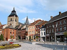
Soignies
| Soignies | ||
|---|---|---|

|

|
|
|
|
||
| State : |
|
|
| Region : | Wallonia | |
| Province : | Hainaut | |
| District : | Soignies | |
| Coordinates : | 50 ° 35 ' N , 4 ° 4' E | |
| Area : | 110.3 km² | |
| Residents: | 28,016 (Jan. 1, 2019) | |
| Population density: | 254 inhabitants per km² | |
| Post Code: | 7060-7063 | |
| Prefix: | 065/067 | |
| Mayor: | Marc de Saint Moulin ( PS ) | |
Local government address : |
Place Verte, 32 7060 Soignies |
|
| Website: | www.soignies.be | |
Soignies ( Dutch Zinnik ), is a French-speaking municipality located on the Senne in the Belgian province of Hainaut with 28,016 inhabitants (as of January 1, 2019).
Soignies is the administrative seat of the Soignies district . Due to the amalgamation of Belgian municipalities since 1977, the municipality includes the town of Soignies as well as the following places: Casteau, Chaussée-Notre-Dame-Louvignies, Horrues, Naast, Neufvilles and Thieusies.
history
At Soignies on July 10, 1794 the French won over the imperial ones.
Personalities
- François de Cuvilliés the Elder (1695–1768), master builder in the service of the Bavarian electorate
- Jules Bordet (1870–1961), microbiologist and immunologist
- Liliane Funcken (1927–2015), artist
- Johan Walem (* 1972), national soccer player
- Jérôme Baugnies (* 1987), racing cyclist
Attractions
- Romanesque basilica of St. Vincent from the 11th century
Web links
Commons : Soignies - collection of images, videos and audio files
Wikisource: Soignies in the Topographia Circuli Burgundici (Mathäus Merian) - sources and full texts
Remarks
- ↑ Soignies . In: Meyers Großes Konversations-Lexikon , 6th edition, 1902-08, Vol. 18, p. 570

