Malmøya
| Malmøya | ||
|---|---|---|
| Waters | Bunnefjord | |
| Geographical location | 59 ° 52 ′ N , 10 ° 45 ′ E | |
|
|
||
| length | 1.47 km | |
| width | 0.85 km | |
| surface | 55 ha | |
| Highest elevation | 53.4 moh. | |
| Residents | 460 (2005) | |
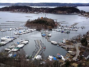
| In the foreground the small island of Padda, in the background Malmøya | ||
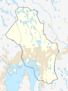
Malmøya ( German Malmö ) is an island of around 55 hectares in the Bunnefjord , the eastern arm of the Oslofjord . It is located about eight kilometers south of the city center of the Norwegian capital Oslo and west of the island of Ulvøya . It is the largest island of Oslo and belongs to the Nordstrand district and within it to the Bekkelaget district .
history
At the end of the 13th century, Malmøya and its offshore island Malmøykalven were owned by a noble family closely associated with the Norwegian royal family, represented at the time by the baron Guttorm Gydasøn . After his death, his widow Jartrud bequeathed Malmøya and Malmøykalven to the collegiate monastery of St. Mary in Oslo in her will on May 8, 1307 . They remained in church ownership until the Reformation in 1537.
In the early 19th century, Malmøya was divided into mansions for the city's most distinguished families. In 1888 there were 62 properties on the island, shortly before the Second World War 141. Today there are 95 houses on the island. On the offshore island of Malmøykalven there was the largest seaside swimming pool in the Oslofjord around 1900 . From 1916 until the Second World War, Ullevål Hospital on the island operated a sanatorium for children with tuberculosis . From 1947 the facility was used as a health resort for children.
Infrastructure
A road connection to the mainland has existed since 1965, when the approx. 120 m long bridge over the Malmøysund to the island of Ormøya was completed. It replaces an earlier ferry connection. The ferryman operated the simple cable ferry by hand and transported both passengers and vehicles. The local supermarket is now located in the ferryman's former home. In 1960 the ferry capsized and was replaced by a passenger ferry. But this ferry also capsized. There were no cars on the island until the bridge was completed, and the Verdens Gang newspaper reported that Malmøya's residents had to row to Oslo to work. At the time the bridge was built, there were plans to enlarge the leisure harbors on the north and east sides of the island, so the bridge is much larger than the roads on both sides. The island's roads are privately owned by Malmøya Veilag. They are narrow and parking on the island is largely prohibited. Bus route 85 connects you to the station square ( Jernbanetorget ) in central Oslo.
There are two kindergartens on the island. The Ormsund Rowing Club and Bundefjord Sailing Club are on the southeast side of the island. In the southwest, in the bay to the island of Malmøykalven, is the Solvik campsite for physically handicapped people. It is operated by the Oslo municipality. The Skinnerbukta bay on the west side is a popular sheltered anchorage with a beach.
Protected areas
On November 2, 1979, seven areas on and around the island were declared a natural monument and animal reserve. The purpose of this measure was to protect the geological conditions and to preserve the limestone pine forest and the bird life. The island is an important resting place and breeding area for sea birds. Four of these areas were merged into a nature reserve on June 27, 2008 .
The following areas have been under protection since then:
- Malmøya and Malmøykalven nature reserve (51 ha)
- Kaninøya nature reserve (2.3 ha)
- Malmøya Brygge naturminne (natural monument; 0.4 ha)
- Nordre Malmøya nature reserve (2.6 ha)
geology
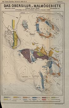
Malmøya is located in the Oslo Trench . There, Caledonian folded sedimentary rocks from the Cambrian , Ordovician and Silurian times , which represent part of the fold and thrust belt of the Swedish-Norwegian Caledonids , have been preserved. In the Permian , during the main phase of Oslo Trench activity, magma rose through the older rock layers in the earth's crust , forming dike rocks and intrusions . Numerous occurrences of rhyolite and trachyte (e.g. the rhombic porphyry known as sediment from northern Germany ) and basalt emerged in the Oslo area at this time.
On Malmøya, mostly folded and therefore not horizontal sedimentary rocks of the highest Ordovician to Upper Silurian ( Wenlockian ) emerge . It is a mixed siliciclastic - carbonatic sequence of a mostly flat, marine deposit area. Many of the rock units have abundant fossils, especially brachiopods and tabulate and rugose corals . This may come as a surprise, since calcifying corals are considered to be tropical marine life, but Oslo is at 60 ° north latitude. It is explained by the fact that " Ur-Europa " (Baltica) in the Ordovician and Silurian, so at the time when these corals lived, was near the equator . As a result of the continental drift , the region then slowly drifted northwards to its current position.
The oldest deposits on Malmøya include the Upper Ordovician ( Hirnantium , approx. 445 mya ) limestone - conglomerates of the Langøyene Formation in the southeast of the island. They cut into the underlying layers like a channel and represent the lowest sea level in the entire sequence. The limestone oils in a siliciclastic-sandy matrix contain u. a. Corals.
The oldest layers of the Silurian are those of the Solvik Formation (early Llandovery , 440 mya). They consist of dark brown clay schist with sandy - silty , rarely calcareous intermediate layers and occur in the east, southeast and south of the island. In particular, the layers deposited in shallower water contain a diverse fossil fauna. There are large numbers of small brachiopods in it. Protatrypa malmoyensis is particularly common . Larger forms such as Leptaena , Eoplectodonta (both Strophomenida ) and Stricklandia ( Pentamerida ) occur with a valve diameter of six to eight centimeters. Fossils of various corals, the calcifying green alga " Mastopora " ( Cyclocrinites ) or trilobites are rarer . Even if the trilobite calymene is one of the symbols of Malmøya, it is seldom found in the rocks of the island compared to other fossils.
The next younger rock unit is the Rytteråker Formation (Mittel-Llandovery, 435 mya), which bites out in the very south of the island . It is a relatively powerful series of mostly lumpy-layered limestone marl stones, which in the higher part contains small reefs in places. These reefs are mainly composed of stromatopores and corals of the genus Favosites and Halysites . Corals and stromatopores as well as pentamerid brachiopods are also relatively common in the rest of the formation.
On the southern edge of the large Skinnerbukta bay , which protrudes into the west of the island, tuber limestone or limestone slate of the Vik formation (Ober-Llandovery, 430 mya) close up. Their layers show nautiloids and remains of sea lilies . The brachiopod Atrypa is also common in the Vik formation in Malmøyas .
On the east side of the Skinnerbukta is the type profile of the Skinnerbukta formation (highest Llandovery – lower Wenlock, 428 mya). This is mainly made up of gray clay slate that was deposited in greater depths of the sea. The fossils therefore mainly contain nautiloids and graptolites .
The youngest sedimentary rock in Malmøya is the Malmøya Formation (Mittel-Wenlock, 425 mya), for which Malmoya is also a type locality. Limestones of the Malmøya formation, the so-called Malmøy lime, are exposed in the center of the island on the highest elevation. These limestones also contain brachiopods, corals and sponges and were temporarily mined to produce cement .
The youngest rocks on Malmøya are Permian ages (300–250 mya). These are not sedimentary rocks, but sub-volcanic rocks that document the magmatism in connection with the tectonic activity of the Oslo trench. For example, the rocks of the Solvik Formation in the south-west of the island are penetrated by a dolerite dike. The surface of both the dolerite and the sedimentary rocks of the Solvik Formation shows glacial scars there that are oriented northwest-southeast. These are evidence of glacier movements during the Pleistocene more than 10,000 years ago, so they are geologically significantly younger than all the rocks on the island.
Individual evidence
- ↑ a b c Malmøya. In: Store norske leksikon . Retrieved April 27, 2014 (Norwegian).
- ↑ Jartrud's surname is not clearly established. However, there is every indication that this is Jartrud Ormsdotter, noble born and sister of Asle and Eirik Ormsson, the Knights King Håkon V were. See Jo Rune Ugulen: "... alle the knaber ther inde och sædescwenne ..." Egg undersøking i den sosiale samansetjinga av den jordeigande eliten på Vestlandet i mellomalderen. Dissertation to obtain a doctorate at the Center for Medieval Studies at the University of Bergen. Bergen (Norway) 2006, p. 125 ( online , Norwegian)
- ^ Diplomatarium Norvegicum. Vol. II, pp. 73/74. Retrieved May 21, 2014 (Norwegian, Old Norwegian).
- ↑ Oslofjorden - Oslomarka tredje bind. Blix forlag, Oslo 1939, p. 64.
- ↑ Harald Gjerde: øyene på internett. 2004, accessed April 27, 2014 (Norwegian).
- ↑ a b turguide til øyene. (pdf) Oslo Kommune, p. 55 , accessed on April 27, 2014 (Norwegian).
- ↑ Malmøya and Malmøykalven. ID VV00000370. In: natural base. Miljø Directoratet, accessed April 27, 2014 (Norwegian).
- ↑ Kaninøya. ID VV00000482. In: natural base. Miljø Directoratet, accessed April 27, 2014 (Norwegian).
- ↑ Malmøya brygge. ID VV00000663. In: natural base. Miljø Directoratet, accessed April 27, 2014 (Norwegian).
- ↑ Nordre Malmøya. ID VV00000664. In: natural base. Miljø Directoratet, accessed April 27, 2014 (Norwegian).
- ↑ a b c d e f g h David L. Bruton, Roy H. Gabrielsen, Bjørn T. Larsen: The Caledonides of the Oslo Region, Norway - stratigraphy and structural elements. Norwegian Journal of Geology. Vol. 90, No. 3, pp. 93–121, PDF (15.0 MB)
- ↑ a b c d e f g h Hans Arne Nakrem, Jan Audun Rasmussen: Oslo Region, Norway. In: Mikael Calner, Per Ahlberg, Oliver Lehnert, Mikael Erlström (Eds.): The Lower Palaeozoic of southern Sweden and the Oslo Region, Norway. Field Guide for the 3rd Annual Meeting of the IGCP project 591.Sveriges geologiska undersökning Rapporter och meddelanden. Vol. 133, 2013, pp. 58–85, PDF (35.5 MB)
- ↑ a b c d e f g h i Et kort innblikk i Malmøyas geologi. UiO Naturhistorisk museum, February 24, 2012, accessed April 27, 2014 (Norwegian).
- ↑ a b Nils Spjeldnæs: The Silurian / Ordovician Border in the Oslo District. Norsk Geologisk Tidsskrift. Vol. 37, No. 3–4, 1957, pp. 355–371, PDF (1.2 MB)
- ^ A b P. J. Brenchley, G. Newall: The stratigraphy of the Upper Ordovician stage 5 in the Oslo-Asker district, Norway. Norsk Geologisk Tidsskrift. Vol. 55, No. 3, 1975, pp. 243-275, PDF (2.5 MB), pp. 264 f.
- ↑ B. Gudveig Baarli: The stratigraphy and sedimentology of the early Llandovery Solvik Formation in the central Oslo region, Norway. Norsk Geologisk Tidsskrift. Vol. 65, No. 4, 1985, pp. 255–275, PDF (1.6 MB)
- ^ A b Nicola K. Möller: Facies analysis and palaeogeography of the Rytteråker Formation (Lower Silurian, Oslo Region, Norway). Palaeogeography, Palaeoclimatology, Palaeoecology. Vol. 69, 1989, pp. 167-192, doi : 10.1016 / 0031-0182 (89) 90163-6
- ↑ B. Gudveig Baarli: depositional environments in the Telychian Stage (Silurian) of the central region Oslo, Norway. Geological Journal. Vol. 25, No. 2, 1990, pp. 65-79, doi : 10.1002 / gj.3350250202
Web links
- Malmøya's website at malmoya.no
- Short presentation of Malmøya with map and pictures on oslooyene.no
- Location of Oslo at the time of the Silurian. UiO Naturhistorisk museum, February 24, 2012, accessed April 27, 2014 (Norwegian).


