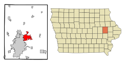
Marion, Iowa
| Marion | |
|---|---|
 Marion City Hall |
|
| Location in Iowa | |
| Basic data | |
| Foundation : | 1839 |
| State : | United States |
| State : | Iowa |
| County : | Linn County |
| Coordinates : | 42 ° 2 ′ N , 91 ° 36 ′ W |
| Time zone : | Central ( UTC − 6 / −5 ) |
| Residents : | 34,768 (as of 2010) |
| Population density : | 1,121.5 inhabitants per km 2 |
| Area : | 31 km 2 (approx. 12 mi 2 ) |
| Height : | 259 m |
| Postal code : | 52302 |
| Area code : | +1 319 |
| FIPS : | 19-49485 |
| GNIS ID : | 458805 |
| Website : | www.cityofmarion.org |
| Mayor : | Snooks Bouska |
 Farmers and Merchants State Bank in the historic old town of Marion, which was admitted to the NRHP in 2009 |
|
Marion is a city (with the status " City ") in Linn County in the eastern part of the US -amerikanischen state of Iowa . In 2010 the city had 34,768 inhabitants.
Marion is part of the metropolitan area around the city of Cedar Rapids .
geography
Marion is located in the northeastern suburb of Cedar Rapids not far from the east bank of the Cedar River . The city is located at 42 ° 02'03 "north latitude and 91 ° 35'52" west longitude and extends over 31 km².
Neighboring towns are Cedar Rapids (10.2 km southwest to the city center), Hiawatha (8.4 km west), Robins (8.5 km northwest), Alburnett (14.2 km north), Whittier (17.3 km northeast) , Springville (8.5 miles east), and Bertram (9 miles southeast).
The closest major cities to Cedar Rapids are Dubuque (105 km northeast), the Quad Cities (123 km southeast), Iowa's former capital, Iowa City (55.9 km south), and Iowa's current capital, Des Moines (206 km west southwest).
traffic
A few kilometers west of the city runs parallel to the Cedar River on Interstate 380 , which is the shortest connection from Waterloo via Cedar Rapids to Iowa City.
The US Highway 151 crosses the city Marion West to east through the city center. Within the city, the highway meets Iowa Highways 13 , 100, and 922 .
Marion Airport is located on the eastern outskirts of Marion . The nearest major airport is Eastern Iowa Airport in Cedar Rapids, 25.6 km to the southwest, and feeder flights connect the region to the most important air traffic hubs in the Midwest.
history
Marion's story began in 1839 when an administrative seat was to be established for Linn County, established two years earlier, and the area that is now the city was chosen. The city was laid out according to plan and named after Francis Marion (1732-1795), a general in the American War of Independence .
In 1844 the first court and administration building was completed. In 1977 it was rebuilt and an administration building was added.
In November 1919, the administrative headquarters were relocated to the rapidly growing neighboring town of Cedar Rapids.
Demographic data
| Population development | |||
|---|---|---|---|
| Census | Residents | ± in% | |
| 1860 | 1367 | - | |
| 1870 | 1822 | 33.3% | |
| 1880 | 1939 | 6.4% | |
| 1890 | 3094 | 59.6% | |
| 1900 | 4102 | 32.6% | |
| 1910 | 4400 | 7.3% | |
| 1920 | 4138 | -6% | |
| 1930 | 4348 | 5.1% | |
| 1940 | 4721 | 8.6% | |
| 1950 | 5916 | 25.3% | |
| 1960 | 10,882 | 83.9% | |
| 1970 | 18,028 | 65.7% | |
| 1980 | 19,474 | 8th % | |
| 1990 | 20,403 | 4.8% | |
| 2000 | 26,294 | 28.9% | |
| 2010 | 34,768 | 32.2% | |
| 1860-1990 2000-2010 | |||
According to the 2010 census , there were 34,768 people in 13,712 households in Marion. The population density was 1121.5 inhabitants per square kilometer.
The racial the population was composed of 93.7 percent white, 2.0 percent African American, 0.3 percent Native American, 1.6 percent Asian and other ethnic groups; 1.9 percent were descended from two or more races. Hispanic or Latino of any race was 2.0 percent of the population.
Statistically, 2.42 people lived in each of the 13,712 households.
26.5 percent of the population were under 18 years old, 60.4 percent were between 18 and 64 and 13.1 percent were 65 years or older. 51.7 percent of the population was female.
The median income for a household was 57,797 USD . The per capita income was $ 29,085. 6.3 percent of the population lived below the poverty line.
Known residents
- Ben F. Jensen (1892–1970) - longtime member of the US House of Representatives (1939–1965) - born in Marion
- Ron Livingston (born 1968) - actor - attended school in Marion
Individual evidence
- ↑ Extract from the National Register of Historic Places - No. 09000930. Retrieved April 18, 2012
- ↑ a b c U.S. Census Bureau, State & County QuickFacts - Marion, IA ( August 14, 2012 memento on WebCite ) Retrieved April 18, 2012
- ↑ Distance information according to Google Maps. Accessed on April 18, 2012
- ^ History of Marion ( April 19, 2007 memento in the Internet Archive ). Retrieved April 18, 2012
- ^ Iowa Data Center (PDF; 84 kB) Retrieved April 18, 2012
