Melkojesee
| Melkojesee | ||
|---|---|---|

|
||
| View to Melkojesee, with Lamskiebergen in the background | ||
| Geographical location |
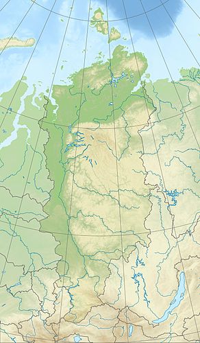
Putorana Mountains , Krasnoyarsk Region ( Russia ) |
|
| Tributaries | Lama , Ajakli , Glubokaja | |
| Drain | Talaya | |
| Location close to the shore | Norilsk | |
| Data | ||
| Coordinates | 69 ° 22 ′ 0 ″ N , 89 ° 16 ′ 0 ″ E | |
|
|
||
| Altitude above sea level | 44 m | |
| surface | approx. 270 km² | |
| length | approx. 28 km | |
| width | Max. approx. 11 km | |
| scope | approx. 98 km | |
| Maximum depth | approx. 22 m | |
| Middle deep | 3.9 m | |
| Catchment area | approx. 12,100 km² | |
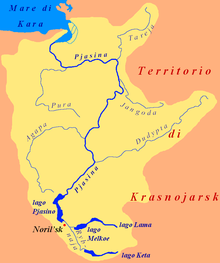
| The catchment area of the Melkojesees | ||
The Melkojesee ( Russian Озеро Мелкое ) is a 270 km² lake on the Putorana Mountains , the northwest part of the Central Siberian Mountains in the Krasnoyarsk region , Siberia , Russia ( Asia ).
Geographical location
The Melkojesee is located around 325 km north of the Arctic Circle in a large valley between the Putorana Mountains to the north and east (max. 1701 m ) and the Lontokoiski-Kamen Mountains (max. 760 m ) to the west . It extends on average about 40 km east of Norilsk .
Each lot away from the lake mountains of Putorana Mountains are in the north Charaelachbergen to approximately 851 m and to the east in the Lamskieberge s to 973 m high. While it is fed by the Lama and streams such as Ajakli and Glubokaja , the Talaja is its only drain, the water of which flows via Norilka and Pjassina to the Kara Sea (part of the Arctic Ocean ).
The lake, located around 44 m high, is around 28 km long and up to 11 km wide. It is an average of 3.9 m and a maximum of about 22 m deep. Its catchment area is about 12,100 km². There are no settlements either by the lake or in its vicinity, but in some places there are isbas , traditional Russian wooden huts. There are some quite large islands in the lake.
In the catchment area of Lake Melkoje, in the east-northeast of the Lama lake , with the Kapchuk lake to the north , and in the east-southeast of the Glubokojesee , with the lakes Gudke , Sobatschje , Nakomjaken and Tonelj above it , as well as numerous small lakes and many rivers.
Name and exploration
On the map of Asiatic Russia published by the Russian General Staff in 1911, the lake is named Bystrovskoye ; for a long time, however, it has been called Melkojesee . It was first explored and described by the Russian-Soviet geologist and polar explorer Nikolai Urwanzew (1893-1985) and his colleague Basanov during an expedition in 1921.
Climate, flora and fauna
The region of the Melkojesees lies in the area of the permafrost soil . The lake is covered by ice from the beginning of October to the end of June or the beginning of July every year . Boreal coniferous forests (taiga) thrive on its flat, sandy and in the hinterland marshy banks with many small lakes and the tundra with mosses and lichens dominates the many plateau-like mountains of the mountains surrounding it . For example, perch fish , pike and salmon fish live in the fish-rich lake .
tourism
The Melkojesee is an attractive tourist destination. In summer, excursion boats bring many visitors to the lake. You drive from the landing stage between Norilsk and its northeastern part of Talnach near the settlement Valjok over the rivers Norilka and Talaja to the lake.
environmental pollution
The factories of the industrial concern MMC Norilsk Nickel , the world market leader in the production of nickel and palladium , located in the Norilsk region , lead to severe environmental pollution , including in the area west of Lake Melkoje .
Individual evidence
- ↑ a b c d Melkoje Lake in the State Water Register of the Russian Federation (Russian)
-
↑ a b c Topographic map (1: 200.000, Bl. R-45-XXIII, XXIV, Ed. 1989), Melkojesee-Nordostteil (bottom) and a. with Lake Lama -Westteil (right), putorana plateau (above), Norilsk (bottom left), Lake Pyasino (left) on mapr45.narod.ru (with height above sea level )
see also (connection card):
Topographic map (1: 200,000 , Bl. R-45-XXIX, XXX, Ed. 1989), Melkojesee-Südwestteil (top center), u. a. with Glubokojesee (top right), Putorana Mountains (right), Ketasee western part (far right below), Lontokoiski-Kamen Mountains (left) and Norilsk (top left) on mapr45.narod.ru

