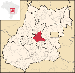
Anápolis microregion
| Anápolis microregion | |
|---|---|
| map | |
| Basic data | |
| State : |
|
| Administrative structure : | Midwest |
| State : |
|
| Mesoregion : | Central Goiás |
| Time zone : |
UTC -3 summer : UTC-2 |
| Area : | 8,311.934 km² |
| Residents : | 540,616 |
| Population density : | 65.0 inhabitants / km² |
| Number of municipalities: | 20th |
| Telephone code : | +5562 |
The Anápolis microregion was a region in the Brazilian state of Goiás determined by the IBGE (Instituto Brasileiro de Geografia e Estatística) exclusively for internal geostatistical purposes . It belonged to the Central Goiás mesoregion and comprised 20 communities. Micro and meso regions are not part of the administrative structure. They existed from 1989 to 2017 and were replaced by a different geostatistical classification.
Geographical location
The microregion Anápolis borders on the microregions (mesoregions):
- In the north at the microregion Ceres ( Central Goiás )
- To the east at Entorno de Brasília ( East Goiás )
- In the southeast at Pires do Rio ( South Goiás )
- In the south at Goiânia (Central Goiás)
- In the southwest at Anicuns (Central Goiás)
- In the northwest on Rio Vermelho ( northwest Goiás )
Municipalities in the Anápolis microregion
| local community |
location | Area (km²) |
Population (2010) |
GDP in 2003 ( R $ 1,000.00) |
|---|---|---|---|---|
| Anápolis | 918.375 | 335.032 | ||
| Araçu | 153.599 | 3,785 | ||
| Brazabrantes | 123.548 | 3,240 | ||
| Campo Limpo de Goiás | 156.202 | 6,270 | ||
| Caturaí | 207.154 | 4,670 | ||
| Damolândia | 84.632 | 2,747 | ||
| Heitoraí | 229.666 | 3,568 | ||
| Inhumas | 613,349 | 48.212 | ||
| Itaberaí | 1,471 | 35,412 | ||
| Itaguari | 135.525 | 4,505 | ||
| Itaguaru | 239,936 | 5,429 | ||
| Itauçu | 383,682 | 8,549 | ||
| Jaraguá | 1,888,938 | 41,888 | ||
| Jesúpolis | 120.919 | 2,293 | ||
| Nova Veneza | 123.376 | 8,129 | ||
| Ouro Verde de Goiás | 209.679 | 4,040 | ||
| Petrolina de Goiás | 540.451 | 10,285 | ||
| Santa Rosa de Goias | 170.970 | 2,905 | ||
| Sao Francisco de Goiás | 339,368 | 6.117 | ||
| Taquaral de Goiás | 201.392 | 3,540 |
See also
Individual evidence
- ↑ a b First results of the 2010 census in Goiás (PDF; 30 kB), carried out by IBGE .


