Moine (river)
| Moine | ||
|
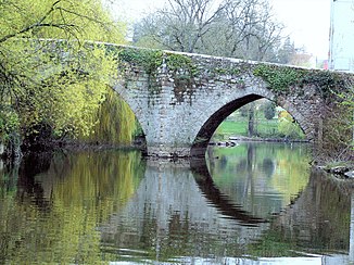
The Pont Saint-Antoine over the Moine at Clisson |
||
| Data | ||
| Water code | FR : M72-0300 | |
| location | France , Nouvelle-Aquitaine regions and Pays de la Loire | |
| River system | Loire | |
| Drain over | Sèvre Nantaise → Loire → Atlantic Ocean | |
| source | in the municipality of Mauléon 46 ° 59 ′ 50 ″ N , 0 ° 40 ′ 18 ″ W |
|
| Source height | approx. 170 m | |
| muzzle | in the urban area of Clisson in the Sèvre Nantaise Coordinates: 47 ° 5 ′ 12 ″ N , 1 ° 16 ′ 43 ″ W 47 ° 5 ′ 12 ″ N , 1 ° 16 ′ 43 ″ W |
|
| Mouth height | approx. 10 m | |
| Height difference | approx. 160 m | |
| Bottom slope | approx. 2.3 ‰ | |
| length | 69 km | |
| Reservoirs flowed through | Lac de Verdon , Lac de Ribou | |
| Medium-sized cities | Cholet | |
| Small towns | Clisson | |
The Moine is a river in France , mainly in the region of Pays de la Loire runs. Although it rises in the municipality of Mauléon , in the neighboring region of Nouvelle-Aquitaine , it leaves this after a few kilometers, generally drains in a north-westerly direction and after 69 kilometers in the urban area of Clisson flows into the Sèvre Nantaise as a right tributary . On his way he touches the Deux-Sèvres , Maine-et-Loire and Loire-Atlantique departments .
