Mont Pèlerin
| Mont Pèlerin | ||
|---|---|---|
|
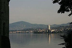
Mont Pèlerin behind Montreux |
||
| height | 1080 m | |
| location | Canton of Vaud , Switzerland | |
| Dominance | 6.55 km → Les Pléiades | |
| Notch height | 325 m ↓ La Tuilière | |
| Coordinates | 552450 / 149 695 | |
|
|
||
| Type | subalpine molasses | |
| rock | Nagelfluh | |
The Mont Pèlerin is a ridge that rises in the Swiss canton of Vaud above the north-eastern shore of Lake Geneva north of the city of Vevey and is considered its local mountain .
geography
The Mont Pèlerin is a mountain range about five kilometers long and two to three kilometers wide in a north-south direction. It lies mainly on the parish of Chardonne , smaller parts belong to Puidoux and the Friborg parish of Granges (Veveyse) . Its summit ( 1080 m above sea level ) is 700 meters above the water level of Lake Geneva and towers over the northern surroundings (hills of the higher plateau and Haute-Broye) by almost 400 meters. North of Mont Pèlerin is Mont Chesau ( 985 m above sea level ), also known as Mont Cheseaux on old maps ; the saddle between the two mountains has its lowest point at 950 m above sea level. M.
The main European watershed between the catchment areas of the Rhone and Rhine runs over the summit of Mont Pèlerin . The short streams that arise on the southern slope flow to Lake Geneva (catchment area of the Rhone), the northern and eastern slopes are drained by the Biorde to Broye (catchment area of the Rhine).

geology
From a geological and tectonic point of view, Mont Pèlerin belongs to the subalpine molasse area . It consists mainly of Nagelfluh , a conglomerate of rounded rock debris (fluvial shaped) with sandstone and claystone as a binding agent.
In the Oligocene (about 36 to 30 million years ago) the area of what is now the Swiss Plateau was covered by a shallow inland sea. After that, the basin ran dry due to large-scale uplift processes, and the Alps began to fold. This also started erosion , and numerous rivers carried the rock debris into the Alpine foothills. One of them was the Ur-Rhône, which deposited a large fan of rubble on the edge of the Alps, especially around 30 to 22 million years ago, the so-called Mont-Pèlerin-Nagelfluh fan . These deposits are now counted among the lower freshwater molasses. The rock material of the Mont-Pèlerin fan originally comes from the Pennine ceilings , it mainly consists of rubble from the simme ceiling . In the course of time, the debris solidified to form today's Nagelfluh conglomerate. Deposits that occurred later were only thin and were largely eroded again. The last tectonically conditioned area of Mont Pèlerin was influenced by the pressure towards the end of the Alpine Folding (in the Pliocene ), when the sediment layers were slightly folded and broken up into individual scales that collapse towards the Alps.
Due to the erosion processes during the Quaternary , the Mont Pèlerin got its present shape. During the ice ages , the mountain was completely covered by the ice from the Rhone glacier . The rounded shape of Mont Pèlerin was created with the glacial erosion and the resulting grinding effect; Ground moraine material was deposited on the slopes .
use
The ridge area of the mountain and the northern part of the western slope are almost entirely forested. Extensive meadowland, interspersed with a few individual farms and holiday homes, extends on the relatively gently sloping upper south-western slope ( Monts de Chardonne ), while the steeper eastern slope is partly wooded and partly pastureland. On the steep southern slope above Lake Geneva, wine is grown up to around 600 meters , above which are the settlement areas of Chardonne and Jongny .
The southern slope of Mont Pèlerin is accessible from Vevey by a funicular, which was inaugurated in 1900 and is now operated by Transports Montreux-Vevey-Riviera (MVR). The mountain station is located at 810 m above sea level. M. in a panoramic position above Chardonne; it is a popular destination with hotels, restaurants and conference venues.
On the summit of Mont Pèlerin is the 122-meter-high Mont Pèlerin television tower from Swisscom . A lift leads to a viewing platform at a height of around 65 meters above the ground, from which, when the weather is clear, there is a magnificent panorama of Lake Geneva, the Alps and the Swiss Plateau to the Jura.
The Mont Pèlerin Society , founded in 1947 at a conference on Mont Pèlerin, takes its name from the mountain and promotes economic liberalism.
In 1977 Geshe Rabten founded the Tibetan University Institute Rabten Choeling in Chardonne .
Web links
- Le Mont Pélerin - Vues aeriennes - Luftfotografie - aerial photography - photos aeriennes - luftfoto - swiss. In: swisscastles.ch. (Aerial photos of Mont Pèlerin and its surroundings).
- Maps of Switzerland - Swiss Confederation - map.geo.admin.ch. In: map.geo.admin.ch. (official map).


