Montale (Tuscany)
| Montale | ||
|---|---|---|

|
|
|
| Country | Italy | |
| region | Tuscany | |
| province | Pistoia (PT) | |
| Coordinates | 43 ° 56 ' N , 11 ° 1' E | |
| height | 85 m slm | |
| surface | 32 km² | |
| Residents | 10,794 (Dec. 31, 2019) | |
| Population density | 337 inhabitants / km² | |
| Post Code | 51037 | |
| prefix | 0573 | |
| ISTAT number | 047010 | |
| Popular name | Montalesi | |
| Patron saint |
San Giovanni Evangelista (December 27th) |
|
| Website | Montale | |
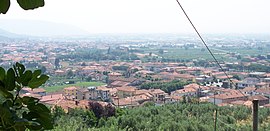
 View of Montale |
||
Montale is an Italian commune with 10,794 inhabitants (as of December 31, 2019) in the province of Pistoia , in the Tuscany region .
geography
Montale lies in the valley of the Ombrone Pistoiese and extends into the foothills of the Apennines . The neighboring municipalities are Agliana , Cantagallo ( PO ), Montemurlo (PO) and Pistoia . The districts Tobbiana, Fognano and Stazione belong to the municipality.
In the main town of Montale, Montale Alto is a Pistoese fortress on a hill that dominates the surrounding landscape.
history
In ancient times, near today's city, there was a station on a Roman road, probably the Via Cassia or the Via Claudia (the exact course of the road is disputed). The Abbazia di San Salvatore was first mentioned in 772. The parish church of S. Giovanni Battista in the Villiano district dates from the 10th century. In 1094 Pope Urban II recognized San Zeno as a cathedral.
The first urban settlement center emerged in the 13th century around the fortress, which was completed in 1206. In the course of the conflicts between the cities of Pistoia and Florence , it was destroyed and rebuilt several times, captured and razed by Florentine troops in 1303. After the reconquest by Pistoia it was not rebuilt, but now served as the seat of the Podestà (Vogts) of an extensive area of land.
At the beginning of the 16th century the municipality - like Pistoia - became part of the Grand Duchy of Tuscany .
The area of the municipality has remained roughly the same since the Middle Ages, until the former district of Agliana became an independent town in 1913 .
Demographics

Attractions
- The Castello della Smilea was built as a medieval fortress and captured by the Florentines in 1466. It was later converted into a residential building. The name probably derives from sei miglia (six miles), the distance to the city of Pistoia.
- Abbazia di San Salvatore in Agna with crypt from 10/11. century
- The Church of San Giovanni Evangelista (S. Giovanni Battista) in Montale was the oldest parish church in the area, it dates back to Romanesque times and was remodeled in the 18th and 19th centuries so that it is now designed in the classicist style.
- Casa al Bosco
Town twinning
-
 Varaždin (Croatia)
 -
 Senlis (Oise) (France), since 2003
 -
 Langenfeld (Rhineland) (Germany), since 2013
Sons and daughters of the church
- Atto Vannucci (1808-1883), historian
Web links
Individual evidence
- ↑ Statistiche demografiche ISTAT. Monthly population statistics of the Istituto Nazionale di Statistica , as of December 31 of 2019.


