
Ombrone Pistoiese
| Ombrone Pistoiese | ||
 Location of the Ombrone Pistoiese |
||
| Data | ||
| location | Tuscany region , Italy | |
| River system | Arno | |
| Drain over | Arno → Tyrrhenian Sea | |
| River basin district | Appennino Settentrionale | |
| source |
Pistoia , about 1 km northeast of the district Sammommè 44 ° 2 '29 " N , 10 ° 55' 22" O |
|
| muzzle | In Carmignano (district of Stazione) in the Arno Coordinates: 43 ° 46 '35 " N , 11 ° 3' 54" E, 43 ° 46 '35 " N , 11 ° 3' 54" E
|
|
| length | 42 km | |
| Left tributaries | Fosso di Iolo, Bardena | |
| Right tributaries | Vincio di Brandeglio, Vincio di Montagnana, Stella, Furba | |
| Big cities | Prato | |
| Medium-sized cities | Pistoia | |
| Small towns | Agliana , Quarrata , Campi Bisenzio , Signa | |
| Communities | Poggio a Caiano , Carmignano | |
 The Ombrone Pistoiese at Poggio a Caiano |
||
The Ombrone Pistoiese is a 42 km long river in Italy in the Tuscany region . It runs through the provinces of Pistoia and Prato as well as the metropolitan city of Florence from north to south.
course
The Ombrone Pistoiese rises in the northern municipality of Pistoia about 1 km north-east of the district Sammommè (the district is located at 555 meters above sea level ) near the mountain pass Passo della Porretta (also Passo della Collina called). Approx. 3 km northwest of Pistoia, the Vincio di Brandeglio tributary enters from the right . Then it runs west of the city of Pistoia to the south. To the southwest of Pistoia in the district of Pontelungo, the Vincio di Montagnana flows from the west , then it flows under the A11 autostrada . In the local area of Pistoia, the river spends a total of 22 km before flowing through Ferruccia (district of Agliana ). The river then runs between the places Agliana and Quarrata east of the mountain Monte Albano , whereby it represents the border to Prato and thus also between the provinces of Pistoia and Prato in the eastern municipality of Quarrata.
In the province of Prato, north of Poggetto (northern district of Poggio a Caiano ), first the Iolo comes in from Iolo (western district of Prato ) from the left and the tributary Stella (coming from Serravalle Pistoiese ) from the right , then near the bridge Ponte a Tigliano the tributary Furba (also from the right). Between Poggetto and Poggio a Caiano, it passes the Ponte Leopoldo II bridge (also called Ponte Manetti ) built by Alessandro Manetti in 1833 , which is considered to be the first suspension bridge built in Italy with iron ropes and which was destroyed by the retreating Wehrmacht in August 1944 . The Ombrone now flows east around the town of Poggio a Caiano and passes the bridge Ponte del Molino (Via Roma) and further south the Ponte all'Asse (Via Vittorio Emanuele, both bridges also destroyed in 1944 and later rebuilt), shortly afterwards it becomes the Border river between the province of Prato and the metropolitan city of Florence, where it briefly touches the municipality of Campi Bisenzio and then acts as the border between Signa (FI) and Carmignano (PO) for 3 km . In the district of Stazione (Carmignano) it flows into the Arno as a right tributary.
photos

The bridge Ponte a Tigliano between Poggetto and Ponte a Tigliano near Tavola (district of Prato)
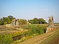
The remains of the Ponte Leopoldo II bridge on the Ombrone Pistoiese

The Ponte all'Asse bridge between Poggio a Caiano and Campi Bisenzio


literature
- Emanuele Repetti: Ombrone Pistojese. In Dizionario Geografico Fisico Storico della Toscana (1833–1846), online edition of the University of Siena (pdf, ital.)
Web links
- Official website of the Sistema Informativo Ambientale della Regione Toscana (SIRA)
- Information about the Ombrone and Ombrone Pistoiese at Enciclopedie on line (Treccani) (Italian)
- Information on Bacino Idrografico dell'Ombrone on the website of the Municipality of Pistoia (Italian)
Individual evidence
- ↑ a b c d cf. SIRA
- ↑ Official website of the ISTAT ( Istituto Nazionale di Statistica ) on the districts and population figures 2001 in the province of Pistoia, accessed on December 10, 2012 (ital.)
- ↑ cf. Enciclopedie on line (Treccani)
- ↑ Structurae to the Ponte Leopoldo II