
Monte Biaena
| Monte Biaena | ||
|---|---|---|
.jpg) Winter on Monte Biaena in the background the Monte Altissimo di Nago |
||
| height | 1622 m slm | |
| location | Trentino ( Italy ) | |
| Mountains | Garda mountains | |
| Coordinates | 45 ° 52 '57 " N , 10 ° 58' 14" E | |
|
||
| rock | Sedimentary rocks , volcanic rocks | |

The Monte Biaena is a mountain in the province of Trento in northern Italy and belongs to the mountain range of the Lake Garda Mountains .
geography
The 1622 m slm high Monte Biaena lies west of Rovereto and east of Ronzo-Chienis between the Gresta and Adige valleys . The mountain ridge running in north-south direction is separated from the Monte Bondone - Monte Stivo group by the Passo Bordala ( 1250 m slm ). In the south, the Camerastal separates it from the Monte Baldo group. There are some Austro-Hungarian trenches from the First World War next to the summit cross .
Flora and fauna
Its east and south sides descend in steps. On these levels there are several places belonging to the communities Isera in the east and Mori in the south, which are used for agriculture by means of field terraces . Vegetables in particular are grown in the upper altitudes, while vineyards are increasingly found in the middle and lower elevations . The wine-growing area around Isera at the foot of the Biaena is known for the cultivation of Marzemino .
On the other hand, its west side drops relatively steeply into the Grestatal and is characterized by dense coniferous forest, while otherwise the coppice dominates. On Monte Biaena there is the rare spring speedwell that is not found in southern Trentino .
At the village of Manzano on the south side there is an exclave of about 1 km² of protected area belonging to the Monte Baldo Nature Park , which is protected because of its species-rich limestone grassland . This habitat was used for haymaking in the past and is now threatened by tree growth.
geology
The Monte Biaena consists mainly of sedimentary rock , namely limestone from the middle and upper Eocene . On the east side there are also the remains of a volcanic vent from the Tertiary period , which explains the presence of basalts and other volcanic rocks on Monte Biaena. The volcano was active about 45 million years ago at the bottom of a sea.
On its west side there are various Glaziokarst shapes, especially layered stairs. After the end of the Würm glacial period and the retreat of the Etsch Glacier , mountain slides slid from the west side. In the rock rubble at the foot of the west wall, a little above Ronzo-Chienis, there is a cave that was created in the process, which was described by the Danish naturalist Niels Stensen in 1671 as one of the first caves in Trentino and named after him Grotta di Stenone . Since ice forms in the cave in winter that does not melt in summer either, it is also known in dialect as the La Giazzera ice cave .
history
The flanks of Monte Biaena were settled as early as the Neolithic . Numerous finds that have come to light near Isera, which range from the Bronze Age to the Romans and were excavated by the archaeologist Paolo Orsi in the 19th century, bear witness to a continuous settlement at the foot of the Biaena, but also in karst caves halfway up the mountain Traces of human presence found in the Bronze Age.
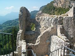
In the Middle Ages, several castles were built on the flanks of Monte Biaena, including Castel Monte Corno at 846 m slm and Castel Pradaglia near Isera, both from the 12th century. On the other hand, Noarna Castle near Nogaredo , whose origins probably go back to the Lombards, is older .
During the First World War there were several Austro-Hungarian caverned artillery positions on the summit of Monte Biaena, as well as an artillery observer who kept the Italian positions on Monte Altissimo di Nago and Monte Pasubio under control. With the help of an optical signal station, the connection to the Serrada plant of the Folgaria and Lavarone barrier group was maintained. From this time, a water catchment basin has been preserved below the summit on the west side, with which rain and melt water was collected in a cistern on the otherwise arid mountain.
Alpinism
The normal route leads from Passo Bordala in about 50 minutes on foot over the western flank to the summit. As you climb to get to the non-public section of cabin section Val di Gresta the Società degli Alpini Tridentini over. Other ascent variants are available from Ronzo-Chienis or from Isera and Mori. From the summit ridge, a short, secured section leads down over the summit structure on the eastern flank to the Malga Somator hut .
photos
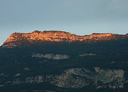
The structure of the summit of Monte Biaena at dawn, seen from Rovereto
The west side with Ronzo-Chienis with clearly recognizable glaziokarst shapes
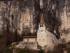
Pilgrimage church of Monte Albano at the foot of Monte Biaena
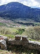
Ruins of Castel Corno in the background the gradual sloping south-east flank of Monte Biaena
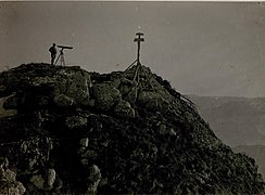
Austro-Hungarian artillery observer in the First World War


.jpg)
literature
- Società degli Alpinisti Tridentini - Sezione del CAI - Commissione Sentieri: … per sentieri e luoghi. Sui monti del Trentino. 6 Prealpi Trentine Occidentali. Casale – Brento, Alpi Ledrensi, Paganella – Monte Gazza, Bondone – Tre Cime, Stivo, Monte Altissimo, Monte Baldo. Euroedit, Trient 2018, ISBN 978-88-941381-4-6 .
Web links
Individual evidence
- ^ A b L'antica attività vulcanica sul Monte Biaena. In: fondazionemcr.it. Retrieved February 29, 2020 (Italian).
- ↑ Manzano. In: areeprotette.provincia.tn.it. Retrieved May 29, 2020 (Italian).
- ↑ La Giazzera. In: protezionecivile.tn.it. Retrieved February 29, 2020 (Italian).
- ↑ Isera - archeologia. In: fondazionemcr.it. Retrieved February 29, 2020 (Italian).
- ↑ Isera - Castel Pradaglia. In: fondazionemcr.it. Retrieved February 29, 2020 (Italian).
- ^ Isera - Castel Corno. In: fondazionemcr.it. Retrieved February 29, 2020 (Italian).
- ↑ Monte Biaena. In: trentinograndeguerra.it. Retrieved May 29, 2020 .
- ↑ Baita Biaena. In: satvaldigresta.it. Retrieved February 29, 2020 (Italian).