
Pasubio
| Pasubio | ||
|---|---|---|
 Pasubio with Val di Fieno on the left and Val Canale on the right |
||
| Highest peak | Cima Palon ( 2232 m slm ) | |
| part of | Vicentine Alps , Eastern Alps | |
|
||
| Coordinates | 45 ° 48 ' N , 11 ° 11' E | |
| rock | limestone | |
| particularities | Heavily contested mountain in the First World War that left numerous traces. | |

The Pasubio is a massif in the Vicentine Alps in Italy on the border between the provinces of Vicenza and Trento . The highest elevation is the Cima Palon with 2232 m slm. The Pasubio is home to the endemic Monte Pasubio mountain cricket .
Containment
The Pasubio is bordered by the Val Leogra in the southeast and Val Posina in the northeast, both in the province of Vicenza, and in the northwest by Val Terragnolo and in the southwest by Vallarsa, which belong to the Trentino. The Passo Pian delle Fugazze ( 1163 m slm ) in the south represents the transition between the Vallarsa and the Val Leogra, the Passo della Borcola ( 1207 m slm ) in the north of the Pasubio connects the Val Terragnolo with the Val Posina. The Passo Xomo ( 1058 m slm ) represents the eastern limit of the massif and connects the Val Leogra with the Val Posina.
Highest peaks
- Cima Palon 2232 m
- Dente Italiano (German Italian plate) 2220 m
- Dente Austriaco (German Austrian plate) 2203 m
history
During the First World War , the Pasubio was the scene of bloody battles between Italian and Austro-Hungarian troops for two and a half years, from June 1916 to November 1918 . Numerous tunnels, caverns and war trails that soldiers from both sides blew up into the mountain still bear witness to these battles, especially the mine war . The mountain range, which runs from north to south, is still disfigured by the war, especially the two plateau-like pre-peaks, of which the northern one was held by the Austrians ("Austrian plate", dente austriaco ), the southern one by the Italians ("Italian plate") , dente italiano ). In between was the so-called “donkey's back” by the Austrians, called Selletta dei Denti by the Italians , the no man's land in which thousands of soldiers died. That is why the mountain is still called "slaughter", "human mill" or "mountain of 10,000 dead".
From 1917, both sides began to drive studs under the back of donkeys in a systematic way. On March 13, 1918, the Austrians detonated a load of 40 tons of dynamon ( ammonium nitrate and red coal ) and 10 tons of chlorate explosives under the Italian plate - which killed over 40 (according to other sources 491 or even 800) Italian soldiers and was the largest in the world The mine used in the First World War is to be considered - but nevertheless could not take the positions of the Italians. The fighting on the Pasubio brought neither side a success until the end of the war.
Attractions
The Pasubio is surrounded by numerous tourist destinations, which is why a detour from Lake Garda , Verona or Venice is possible without much effort. In addition to the history of war, the mountain also offers a lot for outdoor sports enthusiasts and those interested in botanical or geological science.
One of the paths on the Pasubio, the Strada delle 52 Gallerie , leads from Passo Xomo over the Bocchetta di Campiglia to Porte del Pasubio (1928 m). The Rifugio Gen hut is located there . Achille Papa of the Italian Alpine Club (open daily from mid-May to mid-October). The Italians had to build this 6.3 km long route with a total of 52 tunnels in 1917 because their most important supply route, the Strada degli Scarubbi , could be shelled by the Austrian artillery .
The tunnel system on the Austrian plate is particularly interesting, with the Ellison tunnel named after the commander of the Pasubio troops and the mine tunnel leading towards the Italian plate. Old trenches, caverns, emplacements and shell holes can still be seen on the summit itself. Rusted relics of the war, such as shrapnel, and bones or bone fragments of humans are still found. Near the summit is the Santa Maria Chapel, and not far from Pian delle Fugazze is the Pasubio Ossuary . Since 2008 many former positions on the Pasubio have been restored to protect them from further deterioration. Numerous illustrated boards with information about the war events were also set up.
The European long-distance hiking trail E5 ( Konstanz - Venice ) leads over the Pasubio, which coincides in this section with the Friedensweg (sentiero della pace) . The Peace Path , on which the mountain front between Stilfser Joch and the Carnic Alps can be visited, was created in the 1990s through an initiative of the provinces of Trento , Vicenza and Belluno .
Refuges
- Rifugio Achille Papa (1928 m slm)
- Rifugio Vincenzo Lancia (1825 m slm)
photos
 Strada degli Eroi and Porte di Pasubio
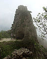 “Corkscrew” in the rock: tunnel no. 20 of the Strada delle Gallerie
 Cosmagnon basin from the Cima Palon
 Strada degli Scarubbi
 Pasubio ossuary at the Pian delle Fugazze pass
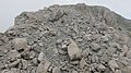 Italian plate (Dente Italiano) with the debris field caused by the Austrian mine on March 13, 1918
 You can't go any further - Brigade Liguria military cemetery


Literature and maps
- Hans Dieter Hübner : On the way in historical footsteps Volume 1. Hikes and excursions on the focal points of the Austro-Hungarian South Tyrol offensive in 1916. Volume 1: Around the Pasubio. Books on Demand, 1st edition 2013, ISBN 978-3-8391-5723-7 .
- Gianni Pieropan: Guida dei Monti d'Italia. Piccole Dolomiti - Pasubio. CAI - TCI , Milan 1978.
- Viktor Schemfil: Pasubio battles 1916/1918. Exact history of the struggle for one of the most important pillars of the Tyrolean defense front, based on Austrian field files and Italian war history works. Verlag E. Kienesberger, Nuremberg, 1984.
- A. Schwertner, B. Erős: Az 1/6. komáromi árkászszázad története - A Passubio felrobbantása. In: De Sgardelli, C. 1941 (szerk.): A Felvidék és Kárpátalja hadtörténete 1914-1918. Budapest, pp. 117-122.
- Robert Striffler: Le 34 mine fatte brillare sul fronte alpino tirolese 1916 - 1918. In: Società Storica per la Guerra Bianca (ed.): Aquile in Guerra No. 1, Rozzano 1993. pp. 43-46 (ital.) ( PDF 1.6 MB )
- Tobacco No. 56 Piccole Dolomiti - Pasubio (1: 25000)
Web links
- Song: "Monte Pasubio" , on it-au-1915-1918.com , accessed on August 5, 2020
- Christoph Wimmer ("el bávaro"): Report: "The Battle of Monte Pasubio" ( Memento from March 19, 2018 in the Internet Archive )
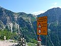
- Pasubio by bike , on bikeab Abenteuer.de , accessed on August 5, 2020
- Peace Path (Italian) , on enrosadira.it , accessed on August 5, 2020
Individual evidence
- ^ Karl Andreas Hofmann : Textbook of the inorganic experimental chemistry. Vieweg Verlag , Braunschweig, 1918. p. 748 ( online in the Google book search)
- ↑ Vincenzo Traniello: Il Pasubio e la guerra di mine . In: Rivista militare italiana Anno II - Febbraio 1928 - N. 2 . Rome, 1928, p. 227 ( PDF 22.2 MB ).
- ^ Robert Striffler (1993), p. 46
- ↑ Robert Striffler: The 34 mine explosions on the Tyrolean mountain front 1916-1918 ( Memento from September 18, 2016 in the Internet Archive )
-
^ Daniela Angetter, Josef-Michael Schramm: About the mining war in high alpine rock and ice regions (1st World War, SW front, Tyrol 1915-1918) from an engineering geological point of view. Geo.Alp, Vol. 11, University of Innsbruck, 2014, 135–160 ( PDF 6.4 MB ).
Here, however, is quoted from a work in which a transcription error made "485" a "485", see discussion: List of the largest artificial, non-nuclear explosions # Pasubio - ↑ Christoph Wimmer
- ↑ Ecomuseum Pasubio , accessed on September 20, 2018.