Monte Cristi
| Monte Cristi | ||
|---|---|---|
| Symbols | ||
|
||
| Basic data | ||
| Country | Dominican Republic | |
| region | Cibao Noroeste | |
| Seat | San Fernando de Monte Cristi | |
| surface | 1,885.8 km² | |
| Residents | 109,607 (2010) | |
| density | 58 inhabitants per km² | |
| ISO 3166-2 | DO-15 | |
Coordinates: 19 ° 43 ′ N , 71 ° 27 ′ W
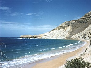
Monte Cristi is a province in the northwest of the Dominican Republic . The coast of the province was first sighted by Christopher Columbus on January 4th, 1493 . He christened the striking mountain he saw "Monte Christy", which is still called El Morro de Montecristi today . After only a brief settlement by the Spaniards, the area sank into insignificance. Only after the capital San Fernando de Monte Cristi was re-established in 1756 did the area experience an upswing again. Finally, in September 1907 , Monte Cristi was made a province.
geography
The province of Monte Cristi is determined by the Cibao Valley and is located at the end of the Carretera Duarte , the main thoroughfare of the Dominican Republic. The province is bounded by the Atlantic Ocean to the north and east .
The surrounding provinces are Puerto Plata , Valverde , Santiago Rodríguez and Dajabón .
economy
The main industries in the province are agriculture and fishing . Mainly are bananas , plantains and rice grown. Since the north-western end of the Cibao Valley is not very rainy, the rice fields are fed by the Rio Yaque del Norte.
The province is the republic's main supplier of table salt, also because of its favorable location.
Major cities and towns
- San Fernando de Monte Cristi , provincial capital
- Castañuela
- Guayubin
- Las Matas de Santa Cruz
- Pepillo Salcedo
- Villa Vázquez


